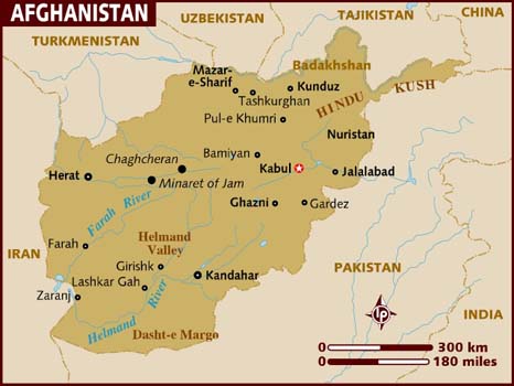
Afghanistan is a mountainous land-locked country located in South-Central Asia.
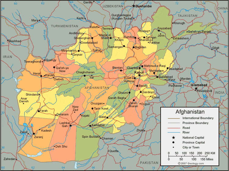
Afghanistan is divided into 34 provinces. The largest city and capital is Kabul.
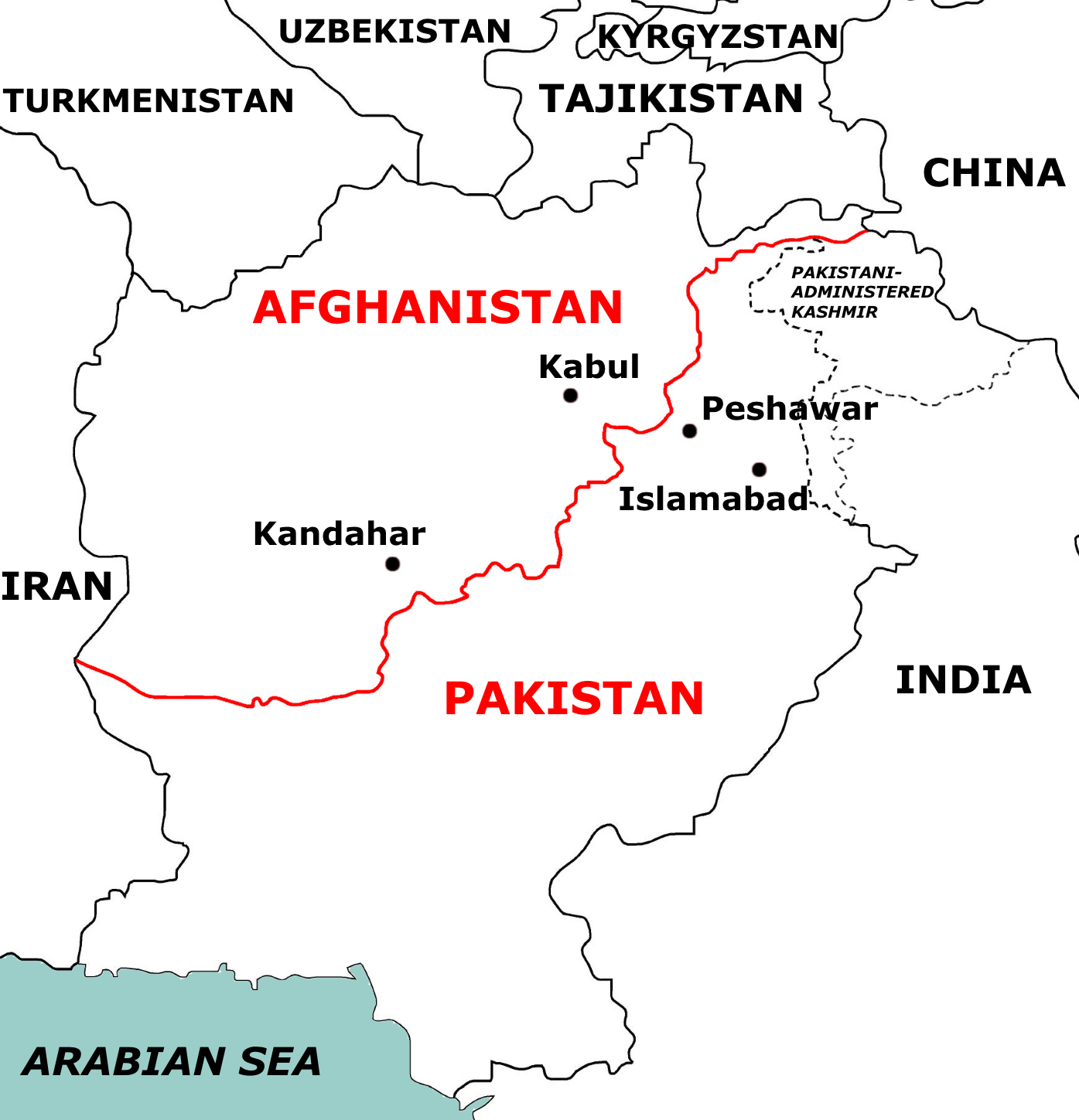
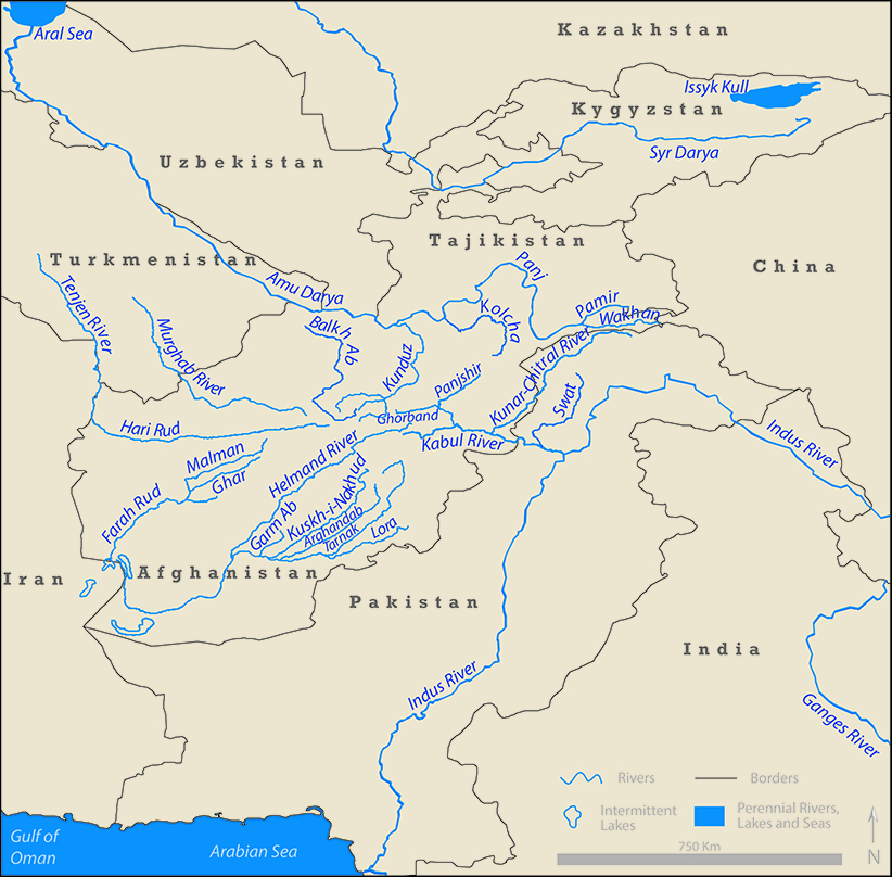
It is bordered by India, Pakistan, Iran, Turkmenistan and Uzbekistan to the north, and Tajikistan and China to the northeast.
It is inhabited by ethnic Pashtuns, Tajiks, Hazaras, and Uzbeks.
The Land
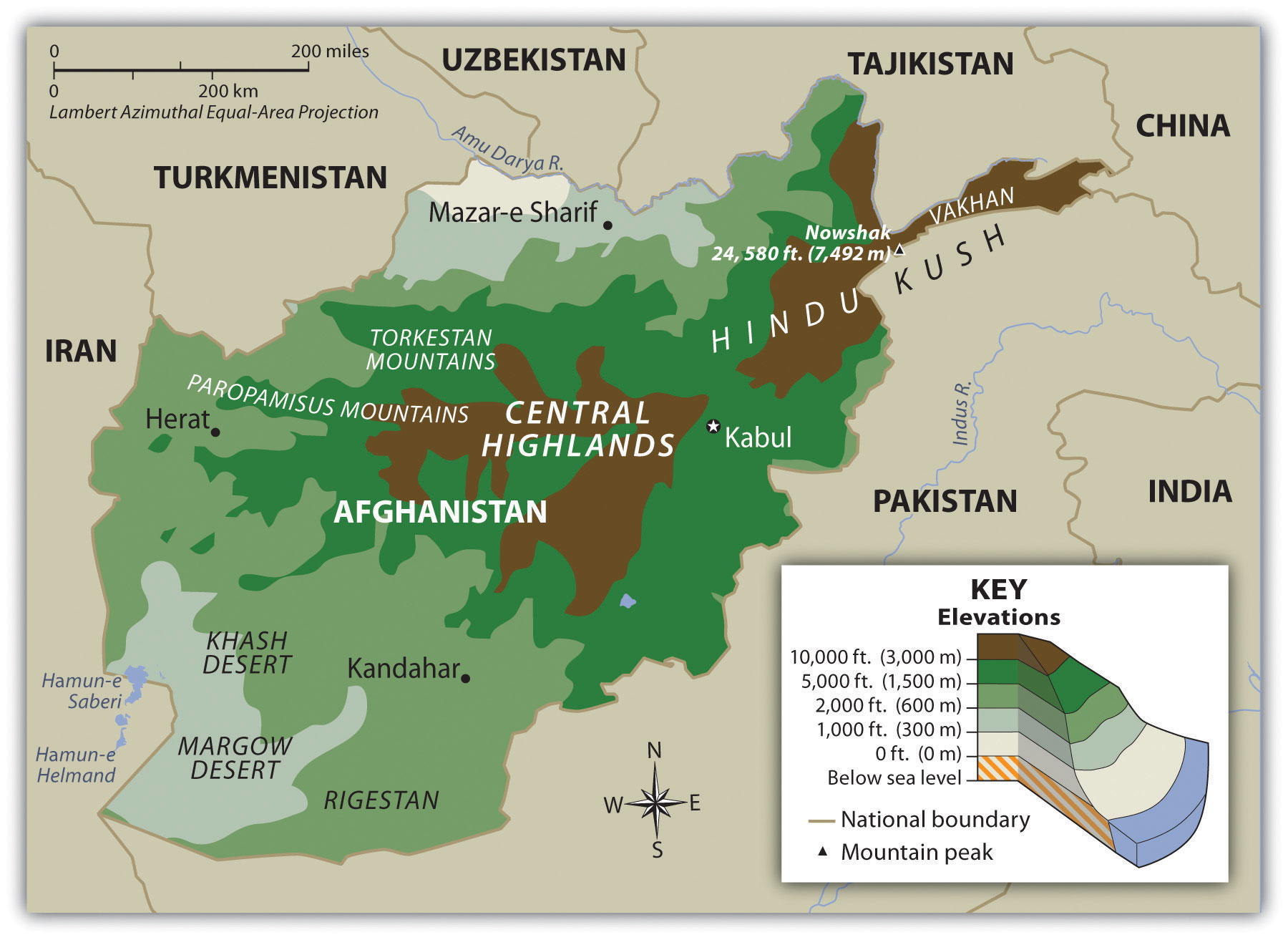
Afghanistan is known for it’s mountainous terrain. The huge Hindu Kush mountains form a barrier between the Northern provinces and the rest of the country. This mountain range has also divided Afghanistan int three very different geographic regions known as: The Central Highlands, The Northern Plains, and the Southwestern Plateau. The altitude, climate, and soil conditions in Afghanistan varies greatly on where in the country you are.
The Central Highlands
One of the most famous routs to the Indian subcontinent, The Khyber Pass, is located in the mountain ranges of the central highlands. The climate in this part of Afghanistan is usually dry. The soil in this region ranges from desert-steppe, to meadow-steppe types.
The Southern Plateau
This region of Afghanistan is made up of high plateaus and sandy deserts. The soil here is very infertile, except along the rivers in the southwest. This region is crossed by several large rivers including the Helmand. Kandahar, which lies at an elevation of about 3,500 feet enjoys a dry, yet mild climate.
The Northern Plains
The Amu river( formerly known as the Oxus) runs through the edge of the foothills. A tremendous amount of the country’s agriculture thrives here. This region also possesses a vast amount of mineral deposits and natural gas.
Afghanistan: Other Details
Geographical High Point: Nowshak 7,485 m
Lowest Point: Amu Darya at 846 feet (258 meters)
Climate: arid to semiarid; cold winters and hot summers
Major Cities: KABUL (capital) 3.573 million (2009), Kandahar, Heart, Mazar-i-Sharif
Major Landforms: Mount Noshaq, Hindu Kush Mountain Range, Pamir Mountains, Southwest Plateau, Northern Plains, Kyber Pass, Wakhan Corridor Major Bodies of Water: Afghanistan is a landlocked and fairly dry country.
Major rivers include Kabul River, Amu Darya, Harirud River, and the Helmand River.
Major Industries: small-scale production of textiles, soap, furniture, shoes, fertilizer, cement; handwoven carpets; natural gas, coal, copper
Natural Resources: natural gas, petroleum, coal, copper, chromite, talc, barites, sulfur, lead, zinc, iron ore, salt, precious and semiprecious stones
Major Exports: opium, fruits and nuts, handwoven carpets, wool, cotton, hides and pelts, precious and semi-precious gems
Major Imports: capital goods, food, textiles, petroleum products
Afghanistan's official languages are Dari and Pashto.
The region centered at Afghanistan is considered the "crossroads of Asia", and the country has had the nickname Heart of Asia.
It is dominated by the Hindu Kush range, the western extension of the Himalayas that stretches to eastern Tibet via the Pamir Mountains and Karakoram Mountains in Afghanistan's far north-east.
The endorheic Sistan Basin is one of the driest regions in the world.
The Amu Darya rises at the north of the Hindu Kush, while the nearby Hari Rud flows west towards Herat, and the Arghandab River from the central region southwards.
To the south and west of the Hindu Kush flow a number of streams that are tributaries of the Indus River, such as the Helmand River.
One exception is the Kabul River which flows in an easternly direction to the Indus ending at the Indian Ocean.
The northeastern Hindu Kush mountain range, in and around the Badakhshan Province of Afghanistan, is in a geologically active area where earthquakes may occur almost every year.
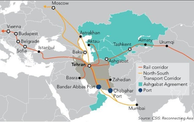
INSTC
The International North–South Transport Corridor (INSTC) is a 7,200-km-long multi-mode network of ship, rail, and road route for moving freight between India, Iran, Afghanistan, Azerbaijan, Russia, Central Asia and Europe.
The route primarily involves moving freight from India, Iran, Azerbaijan and Russia via ship, rail and road.
The objective of the corridor is to increase trade connectivity between major cities such as Mumbai, Moscow, Tehran, Baku, Bandar Abbas, Astrakhan, Bandar Anzali, etc.
Dry runs of two routes were conducted in 2014, the first was Mumbai to Baku via Bandar Abbas and the second was Mumbai to Astrakhan via Bandar Abbas, Tehran and Bandar Anzali.
India proposed the inclusion of Iran's Chabahar port in the International North South Transport Corridor (INSTC)
Chabahar in Iran connects Zahedan and Zaraznj in Iran that can further connect to Delaram, Kandahar and Kabul in Afghanistan.