.jpg)
Disclaimer: Copyright infringement not intended.
Introduction
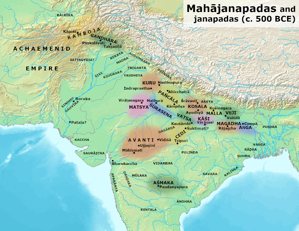
Mahajanapadas is a Sanskrit word (महाजनपद, Mahājanapadas) which means "Great Kingdoms" (from Maha, "great", and Janapada "foothold of a tribe", "country"). Ancient Buddhist texts make frequent reference to sixteen great kingdoms and republics which had evolved and flourished in the northern/north-western parts of the Indian sub-continent prior to the rise of Buddhism in India.
The Mahājanapadas were sixteen kingdoms or oligarchic republics that existed in ancient India from the sixth to fourth centuries BCE during the second-urbanization period.
The 6th–5th centuries BCE is often regarded as a major turning point in early Indian history; during this period India's first large cities arose after the demise of the Indus Valley civilization. It was also the time of the rise of Sramana Movements (including Buddhism and Jainism), which challenged the religious orthodoxy of the Vedic period.
Ancient Buddhist Texts like the Anguttara Nikaya make frequent reference to sixteen great kingdoms and republics which had developed and flourished in a belt stretching from Gandhara in the northwest to Anga in the eastern part of the Indian subcontinent.
Archaeologically, this period has been identified as corresponding in part to the Northern Black Polished Ware culture.
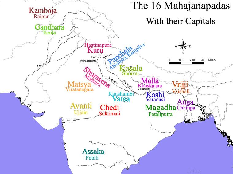
Anguttara Nikaya the ancient Buddhist texts, lists the fallowing as 16 Great Nations (Solasa Mahajanapadas):
Another Buddhist texts written in Pali, Digha Nikaya ("Collection of Long Discourses"), mentions only first 12 Mahajanapadas in this list and omits the last four.
The Jaina Bhagvati Sutra gives a slightly different list of 16 Mahajanapadas: Anga, Banga (Vanga), Magadha, Malaya, Malavaka, Accha, Vaccha, Kochcha (Kachcha?), Padha, Ladha (Lata), Bajji (Vajji), Moli (Malla), Kasi, Kosala, Avaha and Sambhuttara.
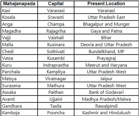
Brief Overview of the Kingdoms
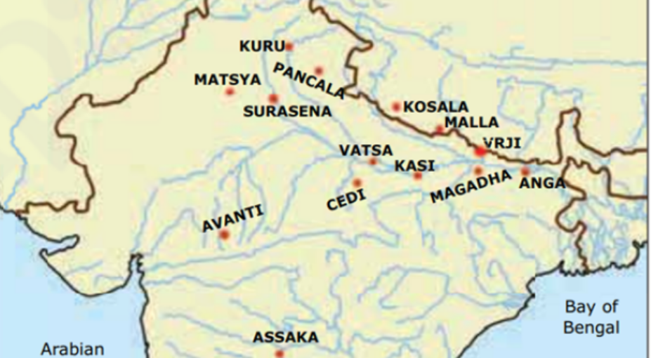
Kasi
This Kingdom was located between the rivers Varuna and Asi. The capital of Kāsī was the city of Vārāṇasī, which was also named Ketumatī, Surundhana, Sudassana, Brahmavaddhana, Pupphavatī, Ramma, and Molinī.
The Kāsikas were first mentioned in the Paippalāda recension of the Atharvaveda.
The Kingdom of Kasi emerged as the most powerful of all Sixteen Mahajanapadas.
The ruling clan of Kāsī appears to have been member of the Bhārata clan. However, the monarchs of Kāsī do not appear to have all belonged to the same dynasty, and the Jātakas frequently mention the extinction of dynasties of the Kāsika kings and their replacement with members from other families regarded as being more competent.
At one point Kāsī was ruled by one Dhṛtarāṣṭra whom the Mahāgovinda Suttanta calls a "Bharata prince."
Some texts reveal that there was a long struggle for supremacy between Kashi and the three kingdoms of Kosala, Anga and Magadha. During this struggle, king Brihadratha conquered Kosala. But later King Kansa incorporated Kashi into Kosala.
Note: Chinese Traveler Huen Tsang referred to the Temple of Kashi.
.jpg)
Kosala
Kosala was located to the north-west of Magadha, with its capital at Savatthi.
Kosala was located between the Nepal hills in the north, the river Sadānīrā in the east, the river Sarpikā or Syandikā in the south, and the river Gomti in the west. The territory of Kosala corresponds to the modern-day Awadh region in present-day Uttar Pradesh to Western Odisha.
The Kosala region gave rise to the Sramana movements, including Jainism and Buddhism.
Kosala belonged to the Northern Black Polished Ware culture (c. 700–300 BCE). It was culturally distinct from the Painted Grey Ware culture of the Vedic period of Kuru-Panchala west of it, following independent development toward urbanisation and the use of iron.
Mahavira, the 24th Tirthankara of Jainism taught in Kosala. A Buddhist text, the Majjhima Nikaya mentions Buddha as a Kosalan, which indicates that Kosala may have subjugated the Shakya clan, which the Buddha belonged to.
According to the Buddhist text Aṅguttara Nikāya and the Jaina text, the Bhagavati Sutra, Kosala was one of the Solasa (sixteen) Mahajanapadas (powerful realms) in 6th to 5th centuries BCE, and its cultural and political strength earned it the status of a great power.
It was ruled by the famous king Prasenajit during the era of Mahavira and Buddha. After the collapse of the Maurya Empire and before the expansion of the Kushan Empire, Kosala was ruled by the Deva dynasty, the Datta dynasty, and the Mitra dynasty. After a series of wars with neighbouring kingdoms, it was finally defeated and absorbed into the Magadha kingdom in the 5th century BCE. King Vidudabha merged Kosala into Magadha.
Anga
The Anga Kingdom was first mentioned in Atharva-Veda along with the Magadhas, Gandharis and Mujavats. The founder of Aṅga was the king Aṅga Vairocana. Anga was famous for its trade and commerce. Mechants used to sail to Suvarnabhumi regularly. In the final days Anga made as an integral part of Magadha Empire. The existence of Anga is attested during the Iron Age.
Counted among the "sixteen great nations" in Buddhist texts like the Anguttara Nikaya, Aṅga also finds mention in the Jain Vyakhyaprajnapti's list of ancient janapadas.
Aṅga proper was located between the Champā river to the west and the Rajmahal hills to the east. However, at times, its territories did extend to the sea in the south, or included Magadha in the west.
The capital of Aṅga, named Campā, was located at the confluence of the Campā and Gaṅgā rivers, and corresponds to the modern-day villages of Campāpurī and Champanagar in the eastern part of the Indian state of Bihār.
The other important cities within the Aṅga kingdom included Assapura and Bhaddiya.
Aṅga's prosperity ended when, in the middle of the 6th century BCE, the Māgadhī crown prince Bimbisāra Śreṇika avenged his father's defeat against Aṅga by defeating and killing the Āṅgeya king Brahmadatta, after which Aṅga became part of the Māgadhī empire, and Campā became the seat of a Māgadhī viceroy.
Magadha
The Magadha was one of the most prominent and prosperous Kingdom of Mahajanapadas.
The territory of the Magadha kingdom proper before its expansion was bounded to the north, west, and east respectively by the Gaṅgā, Son, and Campā rivers, and the eastern spurs of the Vindhya mountains formed its southern border.
Its earliest capital was Rajagaha (modern Rajgir in the Nalanda district of Bihar). Rajagriha was initially known as 'Girivrijja' and later came to be known as so during the reign of Ajatashatru. The other names for the city were Magadhapura, Brihadrathapura, Vasumati, Kushagrapura and Bimbisarapuri. Later on, Pataliputra became the capital of Magadha. The capital city Pataliputra (Patna, Bihar) was situated on the confluence of major rivers like the Ganga, Son, Punpun and Gandak.
Magadha was located in a place (600–200 BCE) in what is now south Bihar (before expansion) at the eastern Ganges Plain.
Magadha was ruled by Brihadratha dynasty, Pradyota dynasty (682–544 BCE), Haryanka dynasty (544–413 BCE), the Shaishunaga dynasty (413–345 BCE) and the Mauryan dynasty by the end of it.
The kingdom of Magadha eventually came to encompass Bihar, Jharkhand, Orissa, West Bengal, eastern Uttar Pradesh, and the areas that are today the nations of Bangladesh and Nepal.
Magadha was succeeded by four of northern India's greatest empires, the Nanda Empire (c. 345–322 BCE), Maurya Empire (c. 322–185 BCE), Shunga Empire (c. 185–78 BCE) and Gupta Empire (c. 319–550 CE). The Pala Empire also ruled over Magadha and maintained a royal camp in Pataliputra.
The Magadhan religions are termed the sramana traditions and include Jainism, Buddhism and Ājīvika. The Śramaṇa Movement gave rise to diverse range of heterodox beliefs, ranging from accepting or denying the concept of soul, atomism, antinomian ethics, materialism, atheism, agnosticism, fatalism to free will, idealization of extreme asceticism to that of family life, strict ahimsa (non-violence) and vegetarianism to the permissibility of violence and meat-eating.
Magadha kingdom was the nerve centre of this revolution.
The Magadhan religions are termed the sramana traditions and include Jainism, Buddhism and Ājīvika.
Vajji or Vriji
Vrijji was a confederacy and one of the Principal Mahajanapadas of Ancient India. The inhabitants appear to have consisted of several confederate clans of whom the the Lichchhavis, the Vedehans, Jnatrikas and the Vajjis were the most important.
In Bihar, they existed from the 6th century BCE to the 4th century CE.
The capital city of Vriji was Vaishali. Most of the area in Mithila region in northern Bihar includes Vriji. It also included Darbhanga, Madhubani and Muzaffarpur districts of present-day Bihar state.
Malla
Malla Kingdom was situated in the Gangatic plain between the Kosala and Videha. Buddhist and Jain texts often mention Mallas. Mallas were powerful people residing in Northern South Asia. The Mallas had two branches. The capital of one was Kushinara which is present Kushinagar and the capital of the other was Pava which is present day Fazilnagar.
Kushinara and Pava are very important in the history of Buddhism and Jainism since the time of Lord Buddha and Lord Mahavira, the 24th Tirthankara took his last meal at Kushinara and Pava (Pavapuri) respectively. Buddha fell ill at Pava and attained Nirvana at Kushinara, while Lord Mahavira took his Nirvana at Pavapuri. Kushinagar is now the center of Buddhist pilgrimage circle.
Chedi or Cheti
Chedi was a kingdom which fell roughly in the Bundelkhand division of Madhya Pradesh regions to the south of river Yamuna along the river Ken. Its capital city was called Suktimati in Sanskrit. Rigveda mentions about Chedis. The Chedis had two distinct settlements of which one was in the mountains of Nepal and the other in Bundelkhand near Kausambi. According to old authorities, Chedis lay near Yamuna midway between the kingdom of Kurus and Vatsas. In the mediaeval period, the southern frontiers of Chedi extended to the banks of the river Narmada.
Vamsa or Vatsa
The Vatsas are stated to be an offshoot of the Kurus. Their kingdom constitutes modern Allahabad/Prayagraj in Uttar Pradesh. It had a monarchical form of government with its capital at Kausambi. The prominent ruler of Vamsa was Udayana. Initially he opposed Buddhism but later on he became a follower of Buddha and encouraged Buddhism in his kingdom. The territory of Vatsa was located to the south of the Gaṅgā river, and its capital was the city of Kauśāmbī or Kosāmbī, on the Yamunā river and corresponding to the modern-day location of Kosam.
The first ruler of the Bhārata dynasty of Vatsa, about whom some definite information available is Śatānīka II, Parantapa.
Śatānīka II married a princess of Videha, who was the mother of Udayana. He also married Mṛgāvatī, a daughter of the Licchavi chieftain Ceṭaka. He attacked Campā, the capital of Aṅga during the rule of Dadhivāhana.
The Buddha visited Kauśāmbī several times during the reign of Udayana on his effort to spread the dharma, the Eightfold Path and the Four Noble Truths. Udayana was an Upasaka (lay follower) of Buddha.
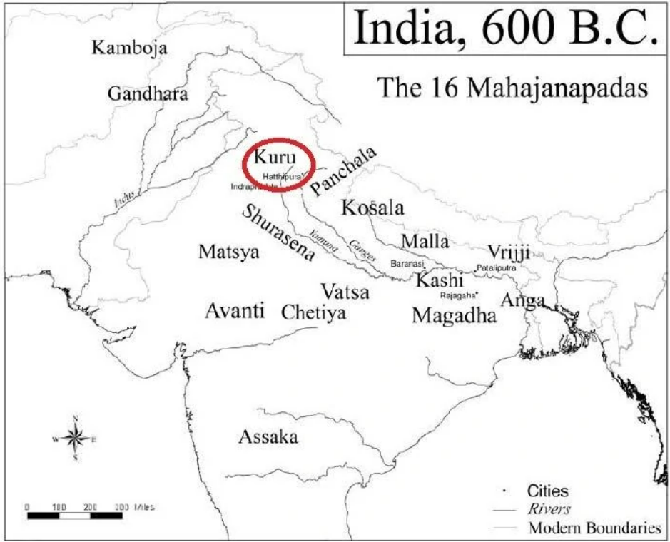
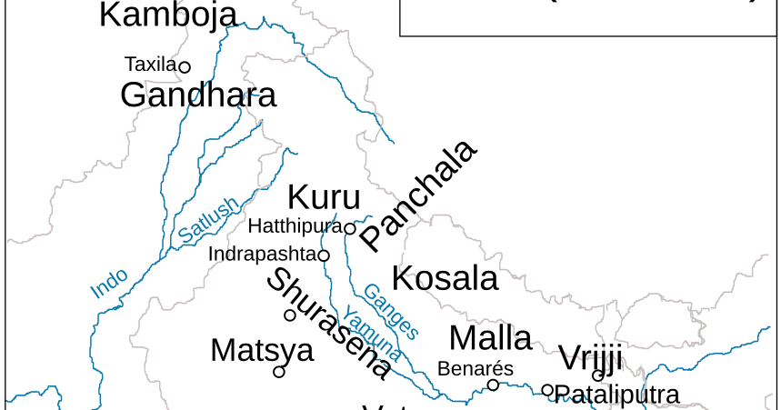
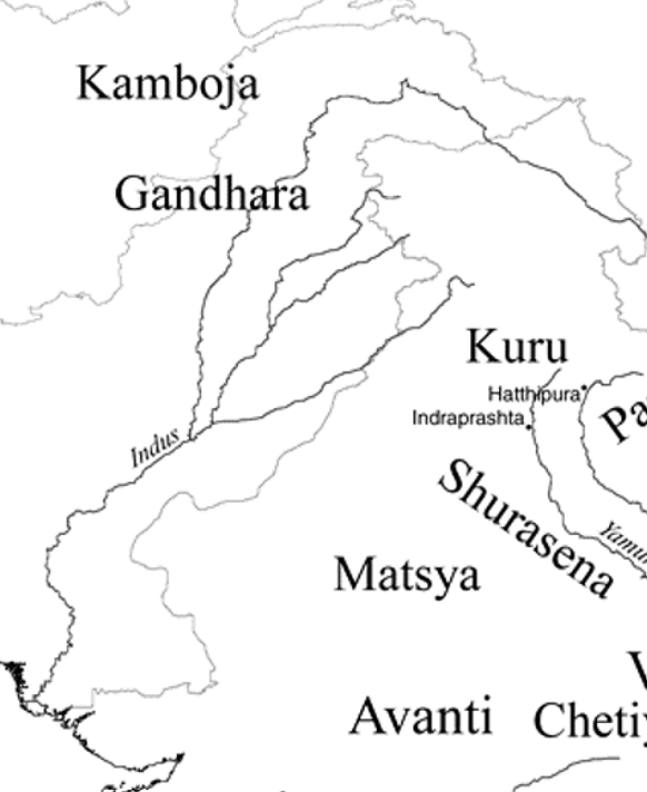
Kuru
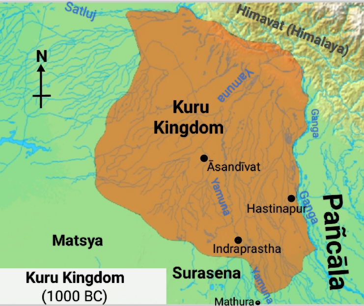
Kuru was a Vedic Indo-Aryan tribal union in northern Iron Age India, encompassing parts of the modern-day states of Haryana, Delhi, and some parts of western Uttar Pradesh, which appeared in the Middle Vedic period (c. 1200 – c. 900 BCE). The Kuru Kingdom was the first recorded state-level society in the Indian subcontinent.
The Kuru state stretched from the Gaṅgā river and the border of the Pañcāla state in the east to the Sarasvatī and the frontier of Rohītaka in the west, and bordered the Kulindas in the north and the Sūrasenas and Matsya in the south.
The country of the Kurus roughly corresponded to the modern Thanesar, state of Delhi, and Meerut district of Uttar Pradesh.
The Kuru clan was formed in the Middle Vedic period (c. 1200 – c. 900 BCE) as a result of the alliance and merger between the Bharata and other Puru clans, in the aftermath of the Battle of the Ten Kings. With their center of power in the Kurukshetra region, the Kurus formed the first political center of the Vedic period, and were dominant roughly from 1200 to 800 BCE. The first Kuru capital was at Āsandīvat, identified with modern Assandh in Haryana. Later, literature refers to Indraprastha (identified with modern Delhi) and Hastinapura as the main Kuru cities.
The Kuru kingdom decisively changed the religious heritage of the early Vedic period, arranging their ritual hymns into collections called the Vedas, and developing new rituals which gained their position over Indian civilization as the Srauta rituals.
It became the dominant political and cultural centre of the middle Vedic Period during the reigns of Parikshit and Janamejaya, but declined in importance during the late Vedic period (c. 900 – c. 500 BCE) and had become "something of a backwater" by the Mahajanapada period in the 5th century BCE.
The main contemporary sources for understanding the Kuru kingdom are the Vedas. This trend corresponds to the increasing number and size of Painted Grey Ware (PGW) settlements in the Haryana and Doab area.
The Atharvaveda praises Parikshit, the "King of the Kurus", as the great ruler of a thriving, prosperous realm. Other late Vedic texts, such as the Shatapatha Brahmana, commemorate Parikshit's son Janamejaya as a great conqueror who performed the ashvamedha (horse-sacrifice). These two Kuru kings played a decisive role in the consolidation of the Kuru state.
According to post-Vedic Sanskrit literature, the capital of the Kurus was later transferred to Kaushambi, in the lower Doab, after Hastinapur was destroyed by floods.
Vedic literature of this time period indicates the growth of surplus production and the emergence of specialized artisans and craftsmen. Iron was first mentioned as śyāma āyasa (श्याम आयस, literally "black metal") in the Atharvaveda, a text of this era. Another important development was the fourfold varna (class) system, which replaced the twofold system of arya and dasa from the Rigvedic times.
Panchala
The Panchalas occupied the country to the east of the Kurus between the upper Himalayas and the river Ganga in the Ganges-Yamuna Doab of the Upper Gangetic plain. Panchala roughly corresponded to modern Budaun, Farrukhabad and the adjoining districts of Uttar Pradesh. The Pañcāla state was located to the west of the Gomti river, and the north of the Chambal River.
During Late Vedic times (c. 1100–500 BCE), it was one of the most powerful states of ancient India, closely allied with the Kuru Kingdom.
Panchala was divided into Uttara-Panchala and Dakshina-Panchala. The northern Panchala had its capital at Adhichhatra or Chhatravati (modern Ramnagar in the Bareilly District), while southern Panchala had it capital at Kampilya or Kampil in Farrukhabad District. The famous city of Kanyakubja or Kanauj was situated in the kingdom of Panchala. Originally a monarchical clan, the Panchals appear to have switched to republican corporation in the sixth and fifth century B.C.E. Fourth century B.C.E. Kautiliya's Arthashastra (4th century B.C.E.) attests to the Panchalas following the Rajashabdopajivin (king consul) constitution.
By the c. 5th century BCE, it had become an oligarchic confederacy, considered one of the solasa (sixteen) mahajanapadas (major states) of the Indian subcontinent. After being absorbed into the Mauryan Empire (322–185 BCE), Panchala regained its independence until it was annexed by the Gupta Empire in the 4th century CE.

Machcha or Matsya
The country of the Matsya or Machcha tribe lay to the south of the Kurus and west of the Yamuna, which separated them from the Panchalas. It roughly corresponded to the former state of Jaipur in Rajasthan, and included the whole of Alwar with portions of Bharatpur. The capital of Matsya was at Viratanagara (modern Bairat) which is said to have been named after its founder king Virata. King Sujata ruled over both the Chedis and Matsyas, thus showing that Matsya once formed a part of the Chedi kingdom.
It had Kuru and Surasena mahajanapadas to its north and east respectively.
Surasena
The country of the Surasenas lay to the east of Matsya and west of Yamuna. This corresponds roughly to the modern day Brij region of Uttar Pradesh, Haryana and Rajasthan and Gwalior region of Madhya Pradesh. It had its capital at Madhura or Mathura. Avantiputra, the king of Surasena, was the first among the chief disciples of Buddha, through whose help Buddhism gained ground in Mathura country.
Archaeological excavations at Mathura show the gradual growth of a village into an important city. The earliest period belonged to the Painted Grey Ware culture (1100-500 BCE), followed by the Northern Black Polished Ware culture (700-200 BCE). Mathura derived its importance as a center of trade due to its location where the northern trade route of the Gangetic Plain met with the routes to Malwa (central India) and the west coast.
The Surasena kingdom had lost its independence on annexation by the Magadhan Empire.
Assaka or Ashmaka
Ashmaka or Assaka was a Mahajanapada in ancient India which existed between 700 BCE and 425 or 345 BCE according to the Buddhist texts Anguttara Nikaya. It was located around and between the Godavari river in present-day Telangana and Maharashtra.
Aśmaka was located on the Godāvarī river, between Mūlaka and Kaliṅga.
The capital of Aśmaka was the city variously named Podana, Potali, and Potana, which corresponds to modern-day Bodhan in Telangana.
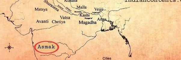
Aśmaka annexed the small kingdom of Mūlaka located to its west during the Mahajanapada period, after which it became the southern neighbour of the kingdom of Avanti.
The Hathigumpha inscription of Kharavela (2nd century BCE) mentions Kharavela's threat to a city variously interpreted as "Masika" (Masikanagara), "Musika" (Musikanagara) or "Asika" (Asikanagara).
Note: In Buddha's time, Assaka was located on the banks of the Godavari river and was the only mahajanapada south of Vindhya mountains. The Ashmakas are also mentioned by Panini. The River Godavari separated the country of Assakas from that of the Mulakas (or Alakas).
Avanti
The country of the Avantis was an important kingdom of western India and was one of the four great monarchies in India in the post era of Mahavira and Buddha, the other three being Kosala, Vatsa and Magadha. Avanti was divided into a northern and a southern part by the Vindhya mountains. Initially, Mahishamati (Mahissati) was the capital of Southern Avanti, and Ujjaini was of northern Avanti. The northern section, which had its capital at Ujjenī, was drained by the Sipra river as well as other streams, while the southern section was drained by the Narmadā and had its capital at Māhissatī or Māhiṣmatī. But at the times of Mahavira and Buddha, Ujjaini was the capital of integrated Avanti.
The kingdom was on the overland trade routes between northern and southern India and to the port of Bharukaccha (modern Bharuch) on the Arabian Sea.
By the lifetime of the Gautama Buddha (flourished c. 6th–4th century BCE), Avanti was one of the four powers of northern India; it was strong enough at that time, under King Pradyota the Fierce, to threaten the empire of Magadha.
In the 4th century BCE Chandragupta of Magadha (founder of the Mauryan dynasty) conquered and annexed Avanti to his dominions.
After 50 BCE, in the Magadha empire’s decline, Avanti was fought over by the Shungas, Andhrabhrtyas, and Shakas; and in the 2nd century CE Ujjayini, under Rudradaman I, was the prosperous capital of the western Shaka satrapy. About 390 CE Chandra Gupta II (who was also called Vikramaditya, patron of the poet Kalidasa) expelled the Shakas and held court at Ujjayini. Avanti gradually began to be referred to as Malwa, after the name of the Malwa (Malava) tribe (which had moved to Avanti).
Gandhara
Gandhāra was an ancient region located in the present-day north-west Pakistan and parts of south-east Afghanistan. The region centered around the Peshawar valley and Swat valley. Gandhara's existence is attested since the time of the Rigveda (c. 1500 – c. 1200 BCE), as well as the Zoroastrian Avesta, which mentions it as Vaēkərəta.
The wool of the Gandharis is referred to in the Rigveda. The river Indus watered the lands of Gandhara. Taksashila and Pushkalavati, the two cities of this Mahajanapada, are named as Taksa and Pushkara.
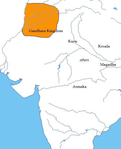
The Iron Age Gandhara kingdom emerged as a major imperial power during the reign of King Pushkarasarin in c.550 BCE. Gandhara was conquered by the Achaemenids in the 6th century BCE, Alexander the Great in 327 BCE, and later became part of the Maurya Empire before being a centre of the Indo-Greek Kingdom. The region was a major centre for Greco-Buddhism under the Indo-Greeks and Gandharan Buddhism under later dynasties, including Indo-Scythians, Indo-Parthians and Kushans. Gandhara was also a central location for the spread of Buddhism to Central Asia and East Asia.
Famed for its unique Gandharan style of art which is influenced by the classical Hellenistic styles, Gandhara attained its height from the 1st century to the 5th century CE under the Kushan Empire, who had their capital at Peshawar (Puruṣapura). Gandhara "flourished at the crossroads of India, Central Asia, and the Middle East," connecting trade routes and absorbing cultural influences from diverse civilizations; Buddhism thrived until the 8th or 9th centuries, when Islam first began to gain sway in the region.
The region steadily declined after the violent invasion by Alchon Huns in 6th century, and the name Gandhara disappeared after Mahmud Ghaznavi's conquest in 1001 CE.
Kamboja
Kamboja was a kingdom of Iron Age India that spanned parts of South and Central Asia, frequently mentioned in Sanskrit and Pali literature. The Kambojas were an Indo-Iranian people of the Kshatriya caste inhabiting the Kamboja Mahajanapada region, forming one of the sixteen nations that made up ancient India from the sixth to fourth centuries BCE during the second-urbanisation period.
While historical boundaries of the Kambojas are varied, scholarly accounts altogether place the northern and western borders in present-day Tajikistan and eastern Uzbekistan, with eastern borders in present-day Jammu and Kashmir, and southern borders in present-day Iran and southern Afghanistan.
The capital of Kamboja was Poonch. It is situated in present-day Kashmir and Hindukush.
The Kamboja Mahajanapada of the Buddhist traditions refers to the 'cis-Hindukush branch' of ancient Kambojas. The Kamboja being one of the sixteen mahajanapadas were a republic since ages. There are many evidence from the Kautiliya's Arthashastra and Ashoka's Edict No. XIII which affirms that the Kambojas were a republic people.

© 2025 iasgyan. All right reserved