Description
Disclaimer: Copyright infringement not intended.
Context
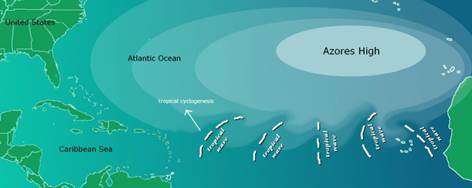
- An extremely large ‘Azores High’ has resulted in abnormally dry conditions across the western Mediterranean, including the Iberian Peninsula, primarily occupied by Spain and Portugal, according to a new study.
What is Azores high?
- The Azores High also known as North Atlantic (Subtropical) High/Anticyclone or the Bermuda-Azores High, is a large subtropical semi-permanent centre of high atmospheric pressure system typically found south of the Azores in the Atlantic Ocean, at the Horse latitudes.
- Azores High extends over the eastern subtropical North Atlantic and western Europe during winter.
- The system influences the weather and climatic patterns of vast areas of North Africa and Southern Europe, and to a lesser extent, eastern North America.
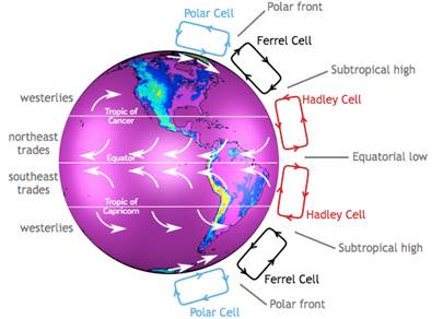
- It is associated with anti-cyclonic winds in the subtropical North Atlantic. It is formed by dry air aloft descending the subtropics and coincides with the downward branch of the Hadley Circulation.
- The aridity of the Sahara Desert and the summer drought of the Mediterranean Basin is due to the large-scale subsidence and sinking motion of air in the system.
- In its summer position (the Bermuda High), the high is centered near Bermuda, and creates a southwest flow of warm tropical air toward the East Coast of the United States. In summer, the Azores-Bermuda High is strongest. The central pressure hovers around 1024 mbar (hPa).
- This high-pressure block exhibits anticyclonic behaviour, circulating the air clockwise. Due to this direction of movement, African eastern waves are impelled along the southern periphery of the Azores High away from coastal West Africa towards the Caribbean, Central America, or the Bahamas, favouring tropical cyclogenesis, especially during the hurricane season.
Expansion of Azores High
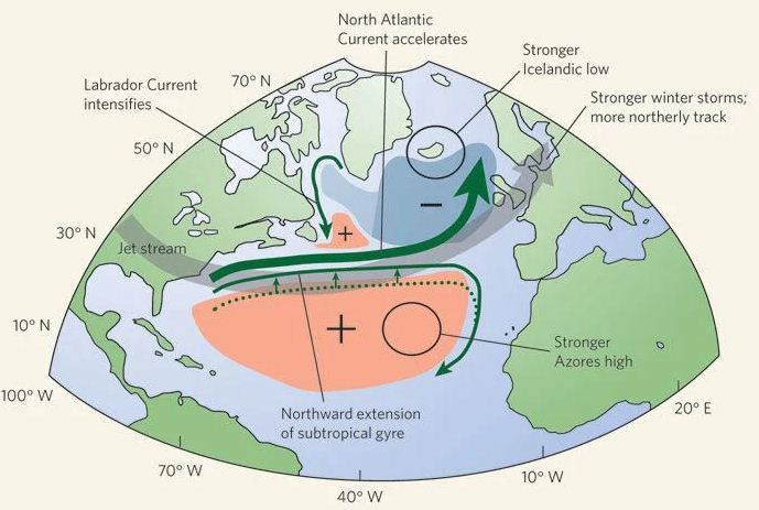
- Reports suggest Global Warming is intensifying the Bermuda High in some years leading to more precipitation extremes across the Southeastern United States.
- The Azores High expansion is driven by external climate forces and that the only external forcing that produces this signal in the industrial era is atmospheric greenhouse gas concentrations.
Study published in Nature Geoscience.:
- Winters with an extremely large Azores High were significantly more common in the industrial era (since 1850) than in pre-industrial times.
- There has been a robust increase in the frequency of extremely large Azores High Area (AHA) events and an overall expansion signal in the winter Azores High over the past 100 years.
- Azores High expansion emerged after 1850 and strengthened in the twentieth century, consistent with anthropogenically driven warming,
Implications of Azores High in the Iberian Peninsula
- An annual drying of 5-10 millimetres per year per decade has been recorded in the Iberian Peninsula throughout the second half of the 20th century. A further 10-20 per cent drop in winter precipitation is expected by the end of the 21st century.
- These projected changes make agriculture of the Iberian region some of the most vulnerable in Europe. The study projected:
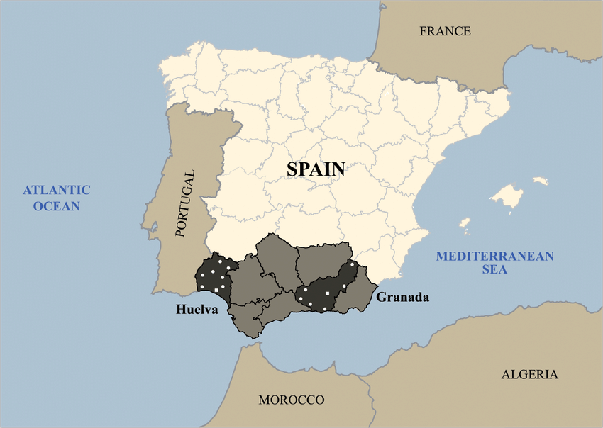
- Olive-growing regions in southern Spain will suffer a 30 per cent decline in production by 2100
- Cultivation area in grape-growing regions across the Iberian Peninsula will shrink 25-99 per cent by 2050 due to severe water deficits that will render land unsuitable for viticulture.
- An expanding Azores High is in concurrent with a pole-ward shift in the North Atlantic storm track and an increase in anticyclone frequency at the Azores High’s poleward edge as well as a positive trend in regional subtropical indicators.
Final Thought
- Expansion of Azores high has important implications for projected changes in the western Mediterranean hydroclimate throughout the twenty-first century.
- And the study is important to understand the future climate risks posed to productive agricultural sectors such as viticulture and olive plantations across the Iberian Peninsula.
|
Iberian Peninsula
The Iberian Peninsula is a peninsula in southwestern Europe, defining the westernmost edge of Eurasia. It is principally divided between Spain and Portugal, comprising most of their territory, as well as a small area of Southern France, Andorra, and Gibraltar.
The Iberian Peninsula is the westernmost of the three major southern European peninsulas—the Iberian, Italian, and Balkan. It is bordered on the southeast and east by the Mediterranean Sea, and on the north, west, and southwest by the Atlantic Ocean. The Pyrenees mountains are situated along the northeast edge of the peninsula, where it adjoins the rest of Europe. Its southern tip, located in Tarifa is the southernmost point of the European continent. Southern tip is very close to the northwest coast of Africa, separated from it by the Strait of Gibraltar and the Mediterranean Sea.
|
https://www.downtoearth.org.in/news/climate-change/extremely-dry-winter-in-western-mediterranean-due-to-expansion-of-azores-high--83656
1.png)


