Description
Disclaimer: Copyright infringement not intended.
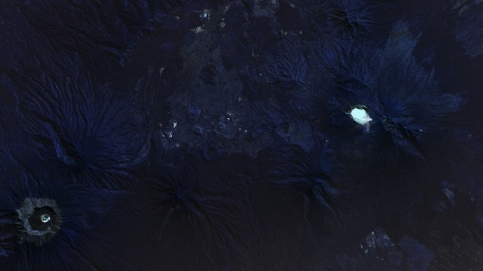
Context
- In the heart of East Java, Indonesia, lies a chilling spectacle known as the Kawah Ijen Crater Lake, often referred to as the 'largest acid cauldron on Earth'.
- The lake's striking turquoise blue waters and otherworldly features make it a unique natural phenomenon and a haunting sight for Halloween.
- The Copernicus Sentinel-2 mission, which provides optical images of Earth's surface, captured the stunning images of this unique natural phenomenon.
Details
Ijen Volcano Complex
- The Ijen volcano complex, situated on the border between Banyuwangi Regency and Bondowoso Regency of East Java, Indonesia, is renowned for its exceptional natural phenomena, including its awe-inspiring blue fire, acidic crater lake, and labor-intensive sulfur mining operations.
Geographic and Geological Significance
- The complex resides within the larger caldera Ijen, spanning approximately 20 kilometers in diameter, with the Gunung Merapi stratovolcano as its highest point, signifying the mountain's fiery nature.
- Ijen Geopark encompasses the entire region, featuring a diverse range of geological, biological, and cultural sites. Notably, it gained recognition as part of the UNESCO Global Geoparks, underscoring its global importance and natural heritage.
Ijen Volcano and Crater Lake
- The Ijen volcano boasts a one-kilometer-wide turquoise-colored acidic crater lake, characterized by its high acidity level and its role as a labor-intensive sulfur mining site, highlighting the stark realities of the local workforce and their challenging daily routines.
- The lake's highly acidic nature has a profound impact on the Banyupahit River, leading to detrimental effects on the downstream river ecosystem due to the discharge of metal-enriched acidic water.
Acidic Properties and Unusual Characteristics
- The lake is renowned for its exceptionally high acidity, primarily owing to the high concentration of sulphuric and hydrochloric acids and dissolved minerals, rendering the water unswimmable.
- With pH levels as low as 0.5, akin to the strength of car battery acid, the lake's unique chemical composition adds to its surreal appearance.
Enigmatic Features
- Beyond its acidic nature, the lake emits hot, flammable sulphurous gases that ignite upon contact with Earth's oxygen-rich atmosphere, creating an enchanting yet eerie blue flame, contributing to the lake's mystical allure.
- The captivating visuals include the presence of the Raung or Gunung Raung Volcano, one of Java's most active volcanoes, towering at an impressive height of 3332 meters, further enhancing the dramatic landscape of the region.
The Blue Fire Crater
- The blue flames, often reaching heights of up to five meters, emerge from cracks at high temperatures, creating an otherworldly spectacle that sets Ijen apart as the largest blue flame area globally.
Sulfur Mining at Ijen
- The active vent at the edge of the lake serves as a significant source of elemental sulfur, supporting a rigorous mining operation.
- Miners endure challenging conditions to extract sulfur, with many facing health risks due to inadequate protection.
- Sulfur extraction is a labor-intensive process, demanding miners to carry loads of sulfur chunks uphill for considerable distances, often making this journey multiple times a day.

Introduction to the Copernicus Program
- The Copernicus Program, formerly known as the Global Monitoring for Environment and Security (GMES), is a flagship initiative by the European Union (EU) in collaboration with the European Space Agency (ESA) and various partner organizations.
- It is dedicated to providing accurate, timely, and easily accessible environmental data and information services to support a wide range of applications, from environmental management to disaster response.
Objectives of the Copernicus Program
Environmental Monitoring
- Copernicus focuses on the systematic monitoring of various environmental factors, encompassing land, atmosphere, and marine domains.
- The program aims to provide comprehensive and sustainable environmental management solutions.
Climate Change Mitigation
- Copernicus plays a pivotal role in the monitoring and analysis of climate change patterns and trends, facilitating the development of strategies for mitigating and adapting to climate change at different levels, from local to global.
Disaster Risk Management
- The program contributes significantly to disaster risk management by providing real-time data and information for early warning systems, preparedness planning, and post-disaster recovery and reconstruction efforts.
Core Components and Services
The Copernicus Program comprises three core components:
Sentinel Satellites
- The program relies on a network of observation satellites, including the Sentinel missions and Contributing Missions.
- These satellites are equipped with advanced sensors and instruments for collecting critical data on land, atmosphere, and oceanographic parameters.
- The Sentinel missions, including Sentinel-1, Sentinel-2, Sentinel-3, and others, form the backbone of the program.
In-situ Measurements
- Ground-based and airborne data-gathering networks play a complementary role in enriching the program's Earth observation capabilities.
- These measurements provide additional information on oceans, continental surfaces, and the atmosphere.
Copernicus Services
- Copernicus offers a diverse range of services, addressing six main themes: atmosphere, marine, land, climate, emergency, and security.
- These services cater to the needs of policymakers, researchers, businesses, and the public, facilitating applications in various domains.
Access to Data and Information
- An essential feature of the Copernicus Program is its commitment to open and free access to data and information.
- This principle fosters transparency, collaboration, and innovation, enabling downstream services and applications to thrive.
History and Evolution
- The Copernicus Program evolved from earlier Earth monitoring initiatives, with substantial research and development efforts in the field of Earth observation.
- The transition from GMES to Copernicus marked a pivotal moment when the EU became directly involved in financing and development.
- The program's shift from research and development (R&D) to operational services was marked by pre-operational services, including Fast Track Services and Pilot Services, phased in between 2008 and 2010.
- Copernicus achieved full operational status in 2014.
Overview of the Sentinel-2 Mission
- With the current constellation comprising Sentinel-2A and Sentinel-2B, and the upcoming Sentinel-2C, the mission focuses on acquiring high-resolution optical imagery over land and coastal waters, facilitating a diverse range of services and applications.
Key Satellites and Launches
Sentinel-2A
- The first satellite, Sentinel-2A, was launched on 23 June 2015, using a Vega launch vehicle.
- It serves as a pivotal component in the acquisition of high-resolution optical imagery over various land and coastal areas, supporting critical applications such as agricultural monitoring and emergency management.
Sentinel-2B
- The launch of Sentinel-2B took place on 7 March 2017, also on a Vega rocket.
- This satellite further bolstered the capabilities of the mission, contributing to the expansion of services related to land cover classification and water quality assessment, among others.
Sentinel-2C
- Scheduled for launch in 2024, Sentinel-2C marks the upcoming addition to the Sentinel-2 constellation.
- Its deployment on a Vega-C launch vehicle is expected to enhance the mission's capabilities in Earth observation and broaden the scope of applications for agricultural monitoring and land cover classification.
Mission Objectives and Services
The Sentinel-2 mission plays a crucial role in providing valuable data for various services and applications, including but not limited to:
- Agricultural monitoring
- Emergency management
- Land cover classification
- Water quality assessment

Conclusion
The Kawah Ijen Crater Lake stands as a captivating reminder of the natural world's diversity and the coexistence of both beauty and danger within our planet's ecosystems.
|
PRACTICE QUESTION
Q. Which of the following statements about the Ijen Crater Lake is true?
- The lake is renowned for its turquoise-colored acidic water, making it one of the largest acidic lakes globally.
- The blue flames observed at the lake's edge are a result of the combustion of sulfuric gas, creating an enchanting yet eerie spectacle.
- The Ijen Crater Lake is located in the central region of Sumatra, Indonesia, and is known for its unique geological formations.
Options:
A. Only Statement 1 and 2 are correct.
B. Only Statement 2 and 3 are correct.
C. Only Statement 1 and 3 are correct.
D. Only Statement 2 is correct.
Answer: A
|


