Description
Copyright infringement not intended
Context
- EOS-02 satellite will be launched in second quarter of 2022- Government.
EOS-01
- About: EOS-02 (formerly known as Microsat-2A) is a planned Indian Earth observation microsatellite being developed by the Indian Space Research Organisation. EOS-02 is based on Microsat-TD.
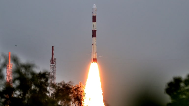
- Launch: EOS-02 will be launched on Small Satellite Launch Vehicle's maiden flight SSLV-D1.
- Mandate: It is intended to be used for cartographic applications at a cadastral level, urban and rural management, coastal land use and regulation, utilities mapping, development and various other GIS applications. The satellite carries two payload: a mid-wavelength and a long-wavelength infared camera with a 6m resolution.
What is an Earth Observation Satellite?
- Earth observation satellite is also known as the Earth remote sensing satellite. As the name suggests, the satellites observe the planet Earth from space.
- The first EOS or remote sensing satellite was Sputnik 1, the first artificial satellite sent to Earth's orbit by the Soviet Union in 1957. It was used to study the topmost layer of Earth's atmosphere, the ionosphere.
- Most EOS operate at about 500 to 600 kilometres from the surface of the earth and due to the substantial air drag they face at such a lower altitude, their orbits have to be rebooted frequently.
Copyright infringement not intended
Types of Earth observation satellites
- EOS can be divided into two types based on how they capture imagery - passive and active.
- Passive satellites detect radiation reflected off the Earth's surface, such as visible light and infrared.
- In general, passive Earth observation satellites (EOS) are not able to work through clouds.
- Active ones transmit energy towards Earth and measures returned signal which gives information about Earth's surface.
- In general, active Earth observation satellites (EO) can see through the clouds.
What are the applications of Earth Observation Satellites?
- These satellites can be used for various purposes, including environmental monitoring, cartography, navigation and more.
- Military of different countries also use the Earth observation satellite for spying and communication. The most common example of applications of EOS are the images of Earth, or the view available in a popular Earth discovery application called Google Earth.
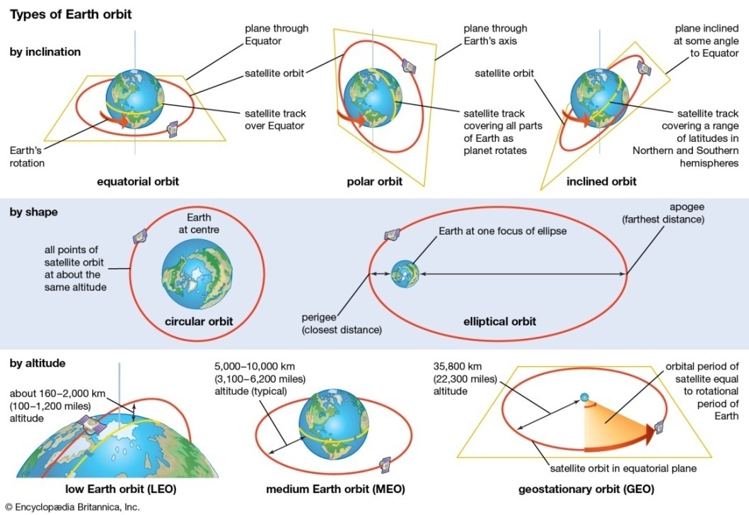
- To get the entire view of the Earth, EOS is placed in a polar orbit.
- The satellites are placed at a point where the relative motion of the satellite and Earth's movement around its polar axis, the satellite is able to get a view of the entire globe.
- To achieve an orbital period of 24 hours, which is also equal to one day on the Earth, EOS has to be placed in a geostationary orbit, which is at 36,000 km from the surface of the Earth.
How earth observational satellites collect data
- Earth Observational Satellites travel on a range of different orbits, offering varying perspectives of the Earth.
- Most satellites do not continuously collect data due to limitations in power and memory. Some offer regular and reliable data acquisition while others collect in small quantities over a period of time.
- Data is stored on-board the satellite until it is in sight of a ground station to downlink the data. The time between an image being taken and being available to download can range between a month to a few minutes and is getting faster as technology progresses.
ISRO's Earth Observational Satellites
- Indian Space Research Organisation (ISRO) has launched many operational remote sensing satellites.
- Many operational satellites are in sun-synchronous orbit and four in Geostationary orbit.
- Operational satellites in Sun-synchronous orbit: RESOURCESAT-1, 2, 2A CARTOSAT-1, 2, 2A, 2B, RISAT-1 and 2, OCEANSAT-2, Megha-Tropiques, SARAL and SCATSAT-1.
- Operational satellites in Sun-synchronous orbit: INSAT-3D, Kalpana & INSAT 3A, INSAT -3DR.
- The data from these satellites are used for several applications covering agriculture, water resources, urban planning.
- It is also used for rural development, mineral prospecting, environment, forestry, ocean resources and disaster management.
ISRO’s EOS Series Satellites
The details of the satellites included in the EOS series are as follows:
- EOS-01: Earth Observation satellite meant for Agriculture, Forestry & disaster management support.
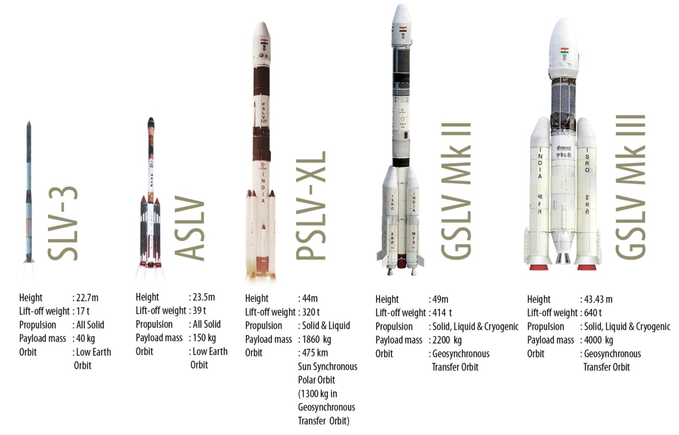
- EOS-02: Technology demonstration satellite for various new technologies with applications that include agriculture, forestry, geology, hydrology etc. and forming the payload for SSLV-1.
- EOS-03 : First Agile Earth Observation satellite in Geostationary orbit and applications which include near real time imaging, quick monitoring of natural disasters, spectral signatures for agriculture, forestry etc.
- EOS-04 : Radar Imaging satellite meant to provide high quality images under all weather conditions for applications such as Agriculture, Forestry & Plantations, Soil Moisture & Hydrology and Flood Mapping.
- EOS-05 : Earth Observation Satellite in the Geostationary Orbit.
- EOS-06 : Earth Observation satellite meant for applications, which include ocean related services and advisories towards potential fishing zone forecast , ocean state forecast
Copyright infringement not intended
List of Earth Observation Satellites
|
Launch Date
|
Launch Mass
|
Launch Vehicle
|
Orbit Type
|
Application
|
|
EOS-04
|
Feb 14, 2022
|
|
PSLV-C52/EOS-04 Mission
|
|
Earth Observation
|
|
EOS-03
|
Aug 12, 2021
|
|
GSLV-F10 / EOS-03
|
GTO
|
Earth Observation
|
|
EOS-01
|
Nov 07, 2020
|
|
PSLV-C49/EOS-01
|
LEO
|
Disaster Management System, Earth Observation
|
|
RISAT-2BR1
|
Dec 11, 2019
|
628 Kg
|
PSLV-C48/RISAT-2BR1
|
LEO
|
Disaster Management System, Earth Observation
|
|
Cartosat-3
|
Nov 27, 2019
|
|
PSLV-C47 / Cartosat-3 Mission
|
SSPO
|
Earth Observation
|
|
RISAT-2B
|
May 22, 2019
|
615 Kg
|
PSLV-C46 Mission
|
LEO
|
Disaster Management System, Earth Observation
|
|
HysIS
|
Nov 29, 2018
|
|
PSLV-C43 / HysIS Mission
|
SSPO
|
Earth Observation
|
|
Cartosat-2 Series Satellite
|
Jan 12, 2018
|
710 Kg
|
PSLV-C40/Cartosat-2 Series Satellite Mission
|
SSPO
|
Earth Observation
|
|
Cartosat-2 Series Satellite
|
Jun 23, 2017
|
712 kg
|
PSLV-C38 / Cartosat-2 Series Satellite
|
SSPO
|
Earth Observation
|
|
Cartosat -2 Series Satellite
|
Feb 15, 2017
|
714 kg
|
PSLV-C37 / Cartosat -2 Series Satellite
|
SSPO
|
Earth Observation
|
|
RESOURCESAT-2A
|
Dec 07, 2016
|
1235 kg
|
PSLV-C36 / RESOURCESAT-2A
|
SSPO
|
Earth Observation
|
|
SCATSAT-1
|
Sep 26, 2016
|
371 kg
|
PSLV-C35 / SCATSAT-1
|
SSPO
|
Climate & Environment
|
|
INSAT-3DR
|
Sep 08, 2016
|
2211 kg
|
GSLV-F05 / INSAT-3DR
|
GSO
|
Climate & Environment, Disaster Management System
|
|
CARTOSAT-2 Series Satellite
|
Jun 22, 2016
|
737.5 kg
|
PSLV-C34 / CARTOSAT-2 Series Satellite
|
SSPO
|
Earth Observation
|
|
INSAT-3D
|
Jul 26, 2013
|
2060 Kg
|
Ariane-5 VA-214
|
GSO
|
Climate & Environment, Disaster Management System
|
|
SARAL
|
Feb 25, 2013
|
407 kg
|
PSLV-C20/SARAL
|
SSPO
|
Climate & Environment, Earth Observation
|
|
RISAT-1
|
Apr 26, 2012
|
1858 kg
|
PSLV-C19/RISAT-1
|
SSPO
|
Earth Observation
|
|
Megha-Tropiques
|
Oct 12, 2011
|
1000 kg
|
PSLV-C18/Megha-Tropiques
|
SSPO
|
Climate & Environment, Earth Observation
|
|
RESOURCESAT-2
|
Apr 20, 2011
|
1206 kg
|
PSLV-C16/RESOURCESAT-2
|
SSPO
|
Earth Observation
|
|
CARTOSAT-2B
|
Jul 12, 2010
|
694 kg
|
PSLV-C15/CARTOSAT-2B
|
SSPO
|
Earth Observation
|
|
Oceansat-2
|
Sep 23, 2009
|
960 kg
|
PSLV-C14 / OCEANSAT-2
|
SSPO
|
Climate & Environment, Earth Observation
|
|
RISAT-2
|
Apr 20, 2009
|
300 kg
|
PSLV-C12 / RISAT-2
|
SSPO
|
Earth Observation
|
|
CARTOSAT – 2A
|
Apr 28, 2008
|
690 Kg
|
PSLV-C9 / CARTOSAT – 2A
|
SSPO
|
Earth Observation
|
|
IMS-1
|
Apr 28, 2008
|
83 kg
|
PSLV-C9 / CARTOSAT – 2A
|
SSPO
|
Earth Observation
|
|
CARTOSAT-2
|
Jan 10, 2007
|
650 kg
|
PSLV-C7 / CARTOSAT-2 / SRE-1
|
SSPO
|
Earth Observation
|
|
CARTOSAT-1
|
May 05, 2005
|
1560 kg
|
PSLV-C6/CARTOSAT-1/HAMSAT
|
SSPO
|
Earth Observation
|
|
IRS-P6 / RESOURCESAT-1
|
Oct 17, 2003
|
1360 kg
|
PSLV-C5 /RESOURCESAT-1
|
SSPO
|
Earth Observation
|
|
The Technology Experiment Satellite (TES)
|
Oct 22, 2001
|
|
PSLV-C3 / TES
|
SSPO
|
Earth Observation
|
|
Oceansat(IRS-P4)
|
May 26, 1999
|
1050 kg
|
PSLV-C2/IRS-P4
|
SSPO
|
Earth Observation
|
|
IRS-1D
|
Sep 29, 1997
|
1250kg
|
PSLV-C1 / IRS-1D
|
SSPO
|
Earth Observation
|
|
IRS-P3
|
Mar 21, 1996
|
920 kg
|
PSLV-D3 / IRS-P3
|
SSPO
|
Earth Observation
|
|
IRS-1C
|
Dec 28, 1995
|
1250 kg
|
Molniya
|
SSPO
|
Earth Observation
|
|
IRS-P2
|
Oct 15, 1994
|
804 kg
|
PSLV-D2
|
SSPO
|
Earth Observation
|
|
IRS-1E
|
Sep 20, 1993
|
846 kg
|
PSLV-D1
|
LEO
|
Earth Observation
|
|
IRS-1B
|
Aug 29, 1991
|
975 kg
|
Vostok
|
SSPO
|
Earth Observation
|
|
SROSS-2
|
Jul 13, 1988
|
150 kg
|
ASLV-D2
|
|
Earth Observation, Experimental
|
|
IRS-1A
|
Mar 17, 1988
|
975 kg
|
Vostok
|
SSPO
|
Earth Observation
|
|
Rohini Satellite RS-D2
|
Apr 17, 1983
|
41.5 kg
|
SLV-3
|
LEO
|
Earth Observation
|
|
Bhaskara-II
|
Nov 20, 1981
|
444 kg
|
C-1 Intercosmos
|
LEO
|
Earth Observation, Experimental
|
|
Rohini Satellite RS-D1
|
May 31, 1981
|
38 kg
|
SLV-3D1
|
LEO
|
Earth Observation
|
|
Bhaskara-I
|
Jun 07, 1979
|
442 kg
|
C-1Intercosmos
|
LEO
|
Earth Observation, Experimental
|
Important Links: https://www.iasgyan.in/blogs/types-of-orbits-explained
https://www.iasgyan.in/daily-current-affairs/eos-03
https://pib.gov.in/PressReleaseIframePage.aspx?PRID=1814390


