Disclaimer: Copyright infringement not intended.
Context
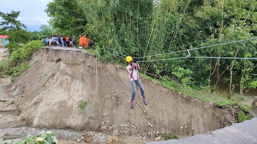
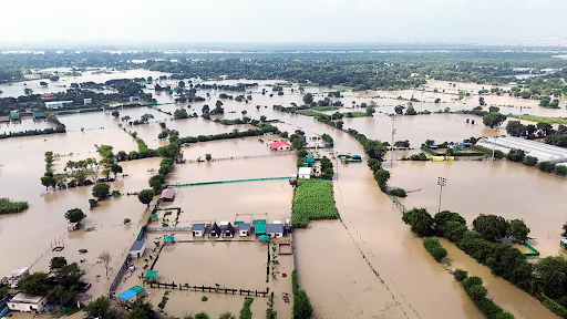
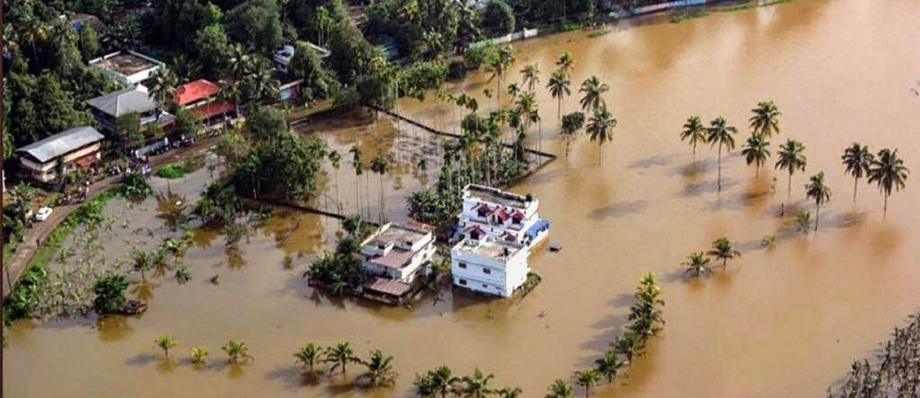
- Floods and landslides have killed three persons and affected more than 56,000 people across eight districts of Assam since May 14.
Flood
- Flood is an overflow of a large amount of water beyond its normal limits, especially over what is normally dry land.
Status of Floods in India
NDRF Report
- 40 million hectares (10% of the land mass) in India is prone to floods.
- On an average every year, 5 million hectares of land is affected, 1600 lives are lost and more than Rs. 1,800 crores is incurred.
Statistics
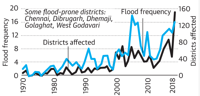
- Between 1970 and 2004, 3 floods occurred per year on an average. However, between 2005 and 2019, the yearly average rose to 11. 19 districts were affected annually on an average until 2005. After 2005, the number jumped to 55.
- 2017 analysis suggests that 4.48 million Indians are exposed to riverine floods, the highest in the world.
Flood Prone Areas in India
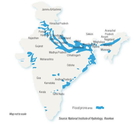
- Punjab
- Haryana
- North Bihar
- West Bengal
- Uttar Pradesh
- Coastal Andhra Pradesh
- Odisha
- Southern Gujarat
- Brahmaputra Valley
Major Causes of Flood in India
Common causes of flood can be divided into the factors triggering it. These factors include -
- Meteorological factors
- Physical factors
- Human factors
Meteorological Factors
The natural causes of flood are discussed below -
- Heavy Rainfall: The season of monsoon enter India in mid-July and stays till the end of September. During this time, rainwater flows and is collected in dams. When this tired or collected water reaches beyond the storage capacity limit, it ends up in flood. Floods caused by rainfall usually occur at the sub-Himalayan plains of West Bengal, Indo-Gangetic, West coast region of West Ghat and Assam.
- Cloud Burst: Cloud Burst occurs due to intense precipitation in a short duration which can sometimes be accompanied by hail and storm and can cause a flood. These natural incidents occur at the mountain slopes, and water runs down towards the plains, causing a flood.
- Cyclone: Cyclones occur in a low-pressure zone where winds rotate inwardly. Cyclones can be accompanied by a massive storm and lead to extreme weather conditions. Four eastern coastal states in India, such as Tamil Nadu, West Bengal, Odisha, Andhra Pradesh, mostly suffer from cyclonic floods.
- Global Warming: Due to the increased rise in global temperature, glaciers of the Himalayan range start to melt. As a result, the seawater level also rises, causing floods in surrounding years.
Physical Factors
Those wondering about what physical factors act as flood causes can get a clear idea from the following section.
- Insufficient Drainage Management: Improper planning of the drainage system of an area can cause excess water due to heavy rainfall to get stuck and lead to a flood.
- Catchment Area: Catchment area is an area from where the rainfall water flows into a river. This can be a lake or reservoir. During monsoon, when excess water exceeds the limit of holding capacity of the catchment area, it leads to floods.
Human Factor
Following is a list of human causes of flood -
- Siltation: Siltation refers to the flow of silt and sediments in the riverbed. As particles remain suspended in the river and accumulated in the riverbed, it disrupts the flow of the river, causing a flood.
- Improper Agricultural Practices: If farmers are not cautious of the effects of farming practices meaning if they leave the waste material into the river or cannot handle water management properly, it can lead to a flood.
- Deforestation: Deforestation is one of the major human causes of floods. Trees act like a sponge that helps to hold soil and water and prevent flooding. As trees are being cut down at a fast pace to make way for urbanisation to grow, more water runs towards a river during heavy rainfall. As a result, a flood occurs.
- Collapse of Dams: Dams are built to store water and provide water to people. As dams are human-made, these can be worn out and subsequently collapse causing floods. Also, if heavy rainfall sustains for a long time, State Governments often declare to open dam gates which can lead to a dangerous flood.
Types of Flood
- Coastal Floods: Coastal floods occur when strong winds or storms move towards the coast during high tide.
- Flash Floods: Flash floods usually occur in hilly areas in limited space. Here the sudden heavy rainfall or snow thaws are the causes of flooding. The fast-moving torrent of Flash floods can sweep large objects such as cars, rocks and everything that comes in their path.
- River Floods: River floods occur due to the inflow of water from heavy rainfall, snowmelt or powerful storms.
- Pluvial Floods: Pluvial floods occur in areas that cannot hold rainwater and end up forming puddles and ponds. These types of floods are the event of rural areas.
- Urban Floods: When the drainage system of urban areas fails to absorb rainwater, it creates urban floods.
Damages Caused by Floods in India
The consequences of flood depend on the location, duration, and vulnerability of the area. The impacts of floods affect both individuals and communities and have social-environmental consequences. Below is a list of damage caused by floods.
- Human Loss and Property Loss: Every year, millions of people become homeless and washed away due to floods.
- Spread of Communicable Diseases: Waterborne diseases like cholera, typhoid fever, hepatitis, and leptospirosis spread in flood-affected areas. Floods also lead to vector-borne diseases, transmitted through parasites and pathogens such as a mosquito. As a result, the health of flood victims deteriorates.
- Destruction of Crops: Every year, floods destroy a large number of crops.
- Loss of Livestock: Like humans, livestock also get displaced during floods and die due to the loss of their habitats.
- Disruption of Communication Link and Transportation: Flood causes damage to transportation links such as bridges, rail, power plants etc., thus causing communication disruption in those areas.
- Economic and Social Disruption: The economy comes to a standstill as people are forced to move to another place, and revival of this situation takes time.
Flood Management
Approaches to dealing with floods may be any one or a combination of the following available options:
- Attempts to modify the flood
- Attempts to modify the susceptibility to flood damage
- Attempts to modify the loss burden
- Bearing the loss.
- The main thrust of the flood protection programme undertaken in India so far has been an attempt to modify the flood in the form of physical (structural) measures to prevent the floodwaters from reaching potential damage centres and modify susceptibility to flood damage through early warning systems.
Structural measures
The following structural measures are generally adopted for flood protection:
- Embankments, flood walls, sea walls
- Dams and reservoirs
- Natural detention basins
- Channel improvement
- Drainage improvement
- Diversion of flood waters.
Non-structural measures
Non-structural measures include:
- Flood forecasting and warning
- Floodplain zoning
- Flood fighting
- Flood proofing
- Flood insurance.
|
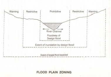
Flood-plain zoning
· Flood-plain zoning measures aim at demarcating zones or areas likely to be affected by floods of different magnitude or frequencies and probability levels. It is hazard mapping to be precise.
· After demarcation it is important to specify the types of permissible developments/constructions in these zones, so that whenever floods actually occur, the damage can be minimized.
· Flood Plain Zoning has been recognized by NDMA as an effective non-structural measure for flood management.
|
Modernization of flood forecasting services
The Central Water Commission is making a constant endeavour to update and modernize forecasting services on a continuous basis to make flood forecasts more accurate, effective and timely. Initiatives being taken for modernizing flood forecasting services are:
- The establishment and modernization of the flood forecasting network, including inflow forecast through automated data collection and transmission; use of satellite-based communication systems through very small aperture terminals; and improvement of forecast formulation techniques using computer-based catchment models;
- Development of a decision-support system for flood forecasting and inundation forecast model for the Mahanadi basin and flash flood forecasting for Sutlej basin;
- Development of a real-time flood-forecasting system for the Brahmaputra and Barak basin, envisaging data collection through automatic sensors and transmission through satellite and forecast formulation using a computer-based mathematical model.
Other
- Planting Mangroves: In order to prevent coastal flooding, State Governments must actively take part in planting more mangroves in coastal areas. Mangroves act as a robust barrier against floods. Hence, governments must focus on mangrove conservation in coastal areas.
- Optimizing Technology: Advancement in technology can help to predict floods. Here, using intelligent flood warning systems like IFFLOWS can prove to be extremely beneficial.
- Channelisation: Channelisation is a deliberate attempt to alter the natural geometry of the river. Channelisation can be achieved in many ways. The river can be deepened and widened to increase the capacity of the channel. This increases its hydraulic efficiency and allows a larger discharge to be contained within the channel. This will help prevent flooding. The channel can be made straighter, through the use of artificial cut-offs.
- Afforestation: During heavy rains, trees reduce the risk of flooding. There are two major ways in which trees provide protection against flooding. Experts say that woodland acts as a barrier to floodwater, while trees also prevent soil erosion, reducing sediment going into rivers and increasing water absorption into the ground. This slows rainwater running off into swollen streams and helps lower peak flood levels.
https://epaper.thehindu.com/Home/ShareArticle?OrgId=GSR9QMV7V.1&imageview=0
https://newsonair.gov.in/News?title=Govt-bans-wheat-export-with-immediate-effect-to-manage-overall-food-security%3b-Assures-no-crisis-of-wheat-and-adequate-food-stock-is-available-in-Country&id=440946
https://pib.gov.in/PressReleasePage.aspx?PRID=1825560