

Disclaimer: Copyright infringement not intended.
Context: INS Shivalik reaches Guam, an island territory of the U.S.
Details
|
Particulars |
Descriptions |
|
Name of the Island |
Guam.
|
|
Country |
An island territory of the United States of America. Became a U.S. territory in 1898. |
|
Capital |
Hagåtña. |
|
Location |
Western Pacific Ocean , North Pacific.
|
|
Formation |
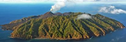
Guam is the largest and southernmost island in the Mariana Islands chain.
Formed by two former volcanoes. |
|
Area |
212 square miles. |
|
Landforms |
Southern Guam is made up of volcanic hills, which rise to a maximum height of 1,334 feet above sea level. The central and northern sections of the island consist of a limestone plateau. |
|
Ethnicity |
Nearly half the people are indigenous Chamorro, 25% are Filipino, 15% migrated from the US mainland, and the rest are Korean, Chinese, Japanese, Micronesian, and Indian. |
|
Culture |
About 85 percent of the population is Roman Catholic. |
|
Ports |
Apra Harbor is the region's finest commercial port. |
|
Coastline |
Sandy beaches, rocky, cliff lines, and mangroves. |
|
Climate |
Tropical Climate. Easterly Trade wind. |
|
Wild life |
A coral reef surrounds most of the island with over 300 types of coral. Guam has five marine protected areas (Pati Point, Piti Bomb Holes, Sasa Bay, Achang Reef Flat, and Tumon Bay), created to help preserve the coral. The Guam kingfisher, Rota white-eye, and the Guam rail are the island’s endemic bird species. Known to Chamorros as the ko'ko', the Guam rail is the territory’s national bird. |
Source
https://19january2017snapshot.epa.gov/www3/region9/islands/guam.html
https://kids.nationalgeographic.com/geography/u-s-states-and-territories/article/guam
https://www.visitguam.com/planning/traveler-essentials/guam-weather/
|
PRACTICE QUESTION Q. consider the following Islands.
Arrange the above Islands in North to South direction. (A) 1,2,3,4 (B) 2,3,4,1 (C) 1,4,3,2 (D) 2,1,3,4 Answer D |


.jpg)

© 2025 iasgyan. All right reserved