Description
Disclaimer: Copyright infringement not intended.
Context
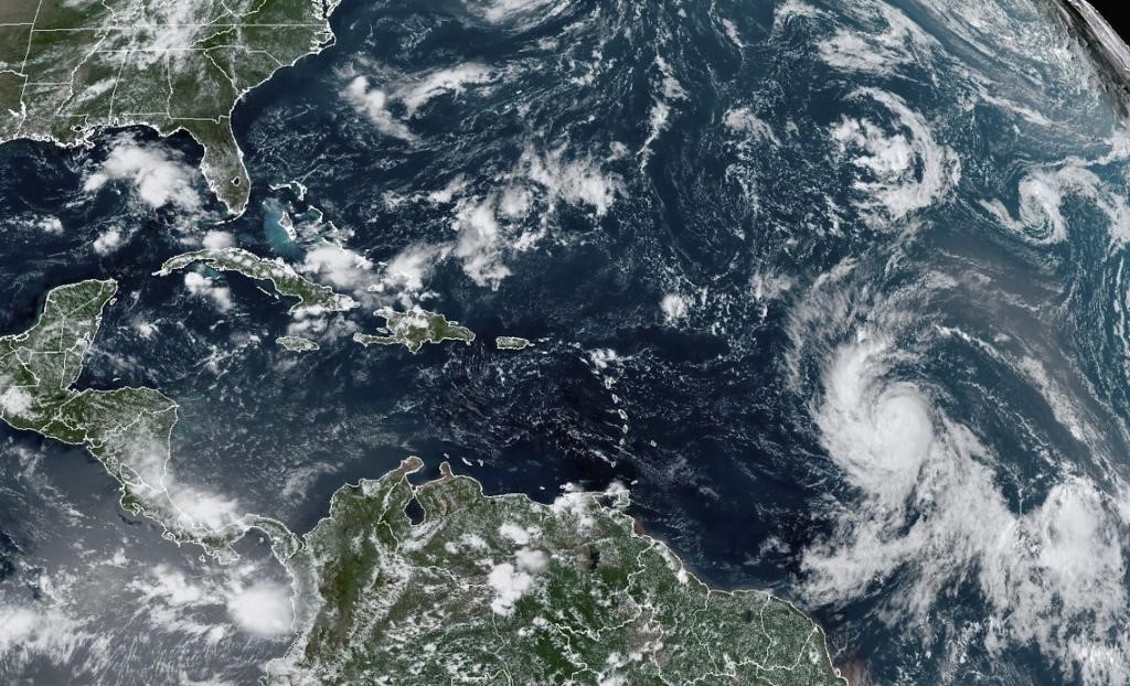
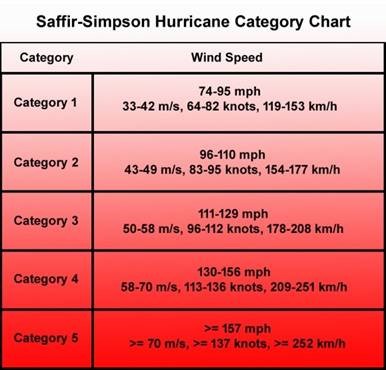
- Hurricane Lee became the busy 2023 hurricane season’s first Category 5 storm and one of the most intense hurricanes on record in the Atlantic Ocean.
- As Hurricane Lee's uncertain storm track could potentially take it toward the Canadian Maritimes, it provides a timely opportunity to reflect on Hurricane Fiona, one year later.
Details
- The aftermath of Hurricane Fiona in Atlantic Canada not only points to the importance of studying how storms affect our communities and their patterns but also underscores Canada's need to better prepare.
- It also raises an interesting question: Can Hurricane Fiona give us a hint about what future climate change might bring to Eastern Canada?
An unprecedented hurricane
- Usually, hurricanes that reach Eastern Canada’s shores weaken into post-tropical cyclones as they enter Canada’s colder waters.
- Nevertheless, Fiona reached Nova Scotia with winds as strong as a Category 2 hurricane, thanks to an extraordinarily low atmospheric pressure of 931.2 mb.
- This led to widespread destruction and made Fiona the most expensive extreme weather event in Atlantic Canada’s history.
- Eastern Canada's coastline is no stranger to destructive hurricane-force winds.
- Situated at the northern edge of the Atlantic hurricane track, the Maritimes region has faced several tropical storms and hurricanes like Hurricane Juan in 2003, Hurricane Igor in 2010, and hurricane Dorian in 2019.
- Between 1900 and 2019, the Canadian Disaster Database recorded 35 similar events that totaled damages exceeding $300 million.
- Adding Fiona, with its $800 million in insured damages, will almost quadruple that number.
- In most aspects, Hurricane Fiona proved to be a record-breaking event in Canada's history, showing us how important it is for communities to think about long-term resilience.
- The issue is that we do not have a very good idea of how much hurricanes might affect us in the future, making it harder for communities to prepare for such events.

Challenges in predicting hurricane risks
- Estimating whether a hurricane will hit a specific location remains complex. Forecasts are mostly limited to short-term outlooks.
- For instance, Environment and Climate Change Canada predicted a near-normal hurricane season for 2023, but they cannot offer forecasts for the next decade.
- While it cannot predict exact hits, it's possible to estimate the chances of a hurricane affecting a certain coastal area each year.
- A crucial part of this involves calculating return periods for severe storms — how often a hurricane of a certain strength is expected to happen. For example, if a major hurricane has a return of 50 years, we might expect about two of these storms in the next 100 years.
- However, this strategy presupposes that storm frequency remains constant over time, which is not always the case and will become increasingly incorrect as global warming continues unabated. Because the climate is not stationary, what is excessive now may be typical tomorrow, and vice versa.
Tropical Storms
- Hurricanes, cyclones, and typhoons are all types of tropical storms. But are given different names depending on where they appear.
- Hurricanes are tropical storms that form over the North Atlantic Ocean and Northeast Pacific.
- Cyclones are formed over the South Pacific and Indian Ocean.
- Typhoons are formed over the Northwest Pacific Ocean.
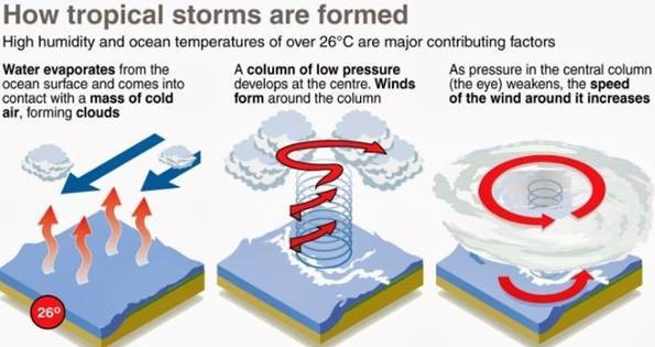
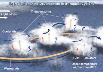
Condition for Cyclone
- Large sea surface with a temperature higher than 27° C,
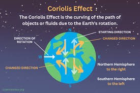
- Presence of the Coriolis force enough to create a cyclonic vortex,
- Small variations in the vertical wind speed,
- A pre-existing weak low-pressure area or low-level-cyclonic circulation,
- Upper divergence above the sea level system
Key Concepts
Coriolis Effect
- The Coriolis Effect is the apparent acceleration of a moving body as a result of the Earth's rotation. It makes things (like planes or currents of air) traveling long distances around the Earth appear to move at a curve as opposed to a straight line.
The Coriolis Effect is an important determinant of wind direction on a global scale
Wind Shear
- Wind shear, also known as wind gradient, occurs when the direction or speed of the wind changes over a short distance.
- Vertical or horizontal wind shear is commonly used to describe atmospheric wind shear.
- Vertical wind shear is a shift in wind speed or direction as one ascends in the atmosphere.
- Horizontal wind shear is defined as a variation in wind speed with lateral position for a given altitude. Low vertical wind shear is required for cyclone formation.
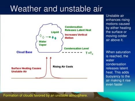
Atmospheric Instability
- Atmospheric stability determines whether or not air will rise and cause storms; sink and cause clear skies; or essentially do nothing.
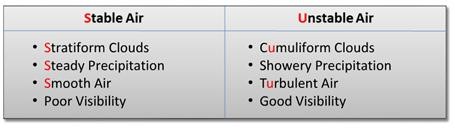
- If an air parcel is warmer than the surrounding environment, it will be less dense and will ascend like a hot air balloon. This is Unstable Air, and it can produce thunder storms if there is enough water vapor present.
- If an air parcel is cooler than its surroundings, it will be denser than the surroundings and sink. Consider this situation to be a pebble sinking in water. This is Stable Air, which usually results in a clear sky.
- If an air parcel is at the same temperature as its surroundings, the packet will not move on its own. This is called Neutral Air.
PRACTICE QUESTION
- Cyclones are natural disasters that pose serious risks to coastal areas. Discuss cyclone creation, features, and impact.
https://www.downtoearth.org.in/blog/natural-disasters/hurricane-fiona-s-legacy-how-studying-storm-impacts-can-help-us-better-prepare-for-future-events-91717
https://www.livemint.com/news/world/watch-pakistani-locals-laud-indias-g20-summit-question-islamabad-s-foreign-policy-the-world-has-sidelined-us-11694671507760.html
https://theconversation.com/hurricane-fionas-legacy-how-studying-storm-impacts-can-help-us-better-prepare-for-future-events-206483