Description
Disclaimer: Copyright infringement not intended.
Context
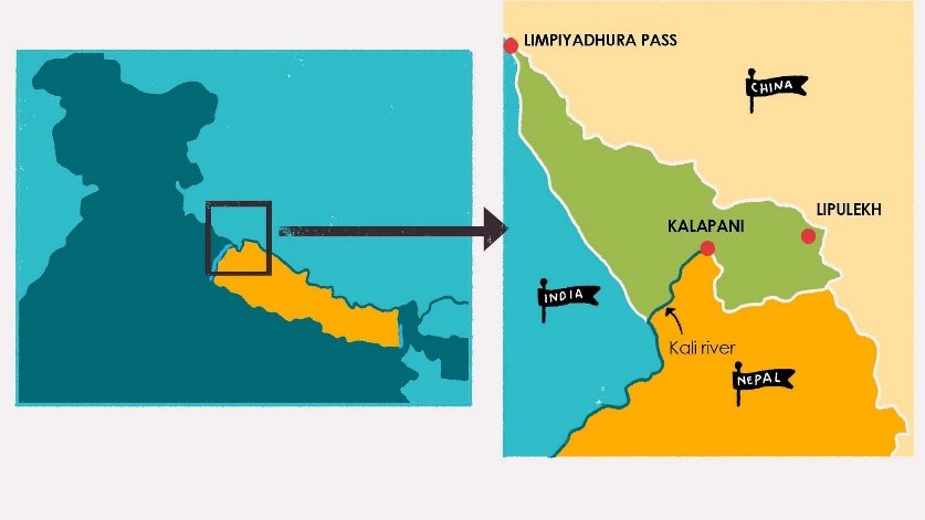
- Recently, Prime Minister Narendra Modi visited Gunji near Kalapani, Uttarakhand.
- This has triggered an uproar in Nepal.
Issue
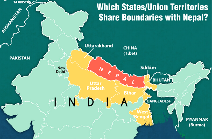
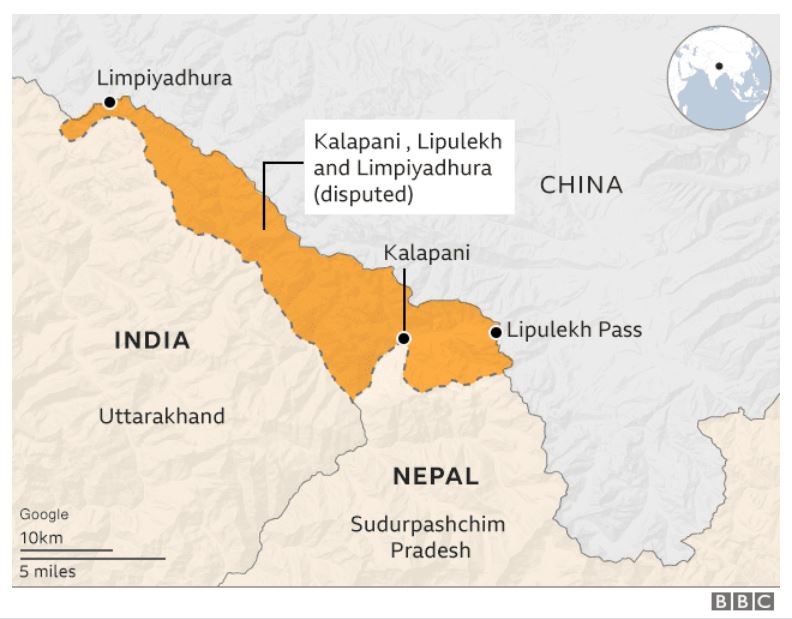
- Kalapani, Limpiadhura, and Lipulekh on the India-Nepal border are included in the official maps of both countries.
- These areas are under India’s administration.
Border Disputes between India and Nepal
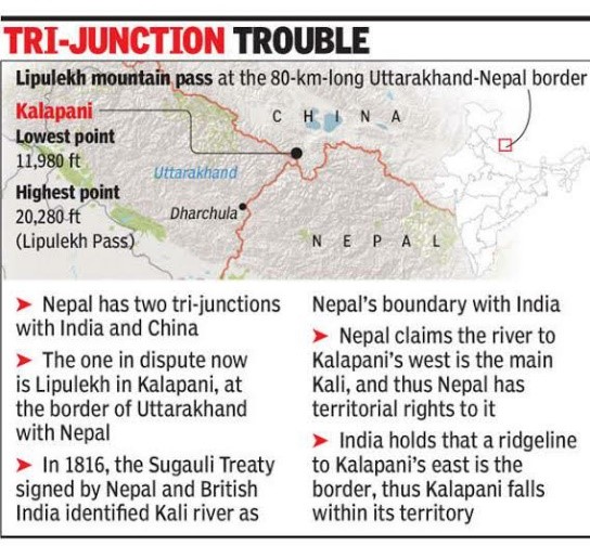
Kalapani-Limpiyadhura-Lipulekh Tri-Junction
- The border between Nepal and India is over 1,700 kilometers long.
- The border is primarily based on the 1816 Sugauli Treaty signed between the British East India Company and the Kingdom of Nepal. The treaty ended the Anglo-Nepal War.
Treaty of Sugauli
- The Treaty of Sugauli established the boundary line of Nepal.
- It was signed on 4th March 1816 between the East India Company and Guru Gajraj Mishra. This was right after the Anglo-Nepalese War of 1814–16.
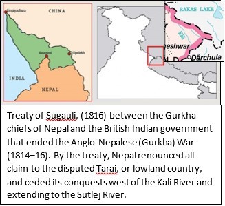
- Thus, the Treaty was the result of a war between the Gorkha Kingdom of Nepal and the British East India Company.
- Under this treaty, when the borders were marked, it was decided that on the western side, the Kali River would mark the border, while on the eastern side, the River Mechi would be the border.
Terms of the Treaty
- Article 5 of the Sugauli Treaty mentions the Mahakali River (or River Kalee as mentioned in the Treaty) as the western boundary of Nepal.
- The Treaty does not indicate the origin of the Mahakali River.
When a River becomes a country’s border, the origin of the river becomes crucial.
In the Sugauli Treaty, the Nepali side and the British East India Company did not sign on any maps.
The maps of the British East Indian Company, in the years following the treaty, show that the origin of the Kali River was near the Limpiyadhura pass, on the western side.
However, realizing the trade importance of this pass, over the next few years, the British East India Company shifted the boundaries to the east of Kalapani.
The monarch who ruled Nepal didn’t raise an objection.
Over a period of time, this became the border between India and Nepal.

Genesis of the Dispute
Nepal's claim
- Nepal says Limpiyadhura or the nearby Lipulekh pass is the origin of the Mahakali River (or River Kalee).
- Thus, Nepal justifies Limpiyadhura at the trilateral junction between India, Nepal, and China as its inherent part.
India's stand
- India argues that the River Kali originated from a smaller rivulet named
- Pankhagad lies on the southern portion of Kalapani and the subsequent ridge on the eastern part of this area is the true border. Thus, the territory is part of India.
Different names and confusion
- The river is known as ‘Kali’ at the upper reaches, the middle portion is called ‘Mahakali’, and the lower, ‘Sarjoo’ or ‘Gogra’. This aggravates the confusion about where it belongs.
Maps between 1846-1880
Map Published by East India Company 1st Feb.1827
- It shows the River Kali originating about 16 kilometers northwest of Kalapani at Limpiyadhura in the Zanskar range of the Himalayas.
Map 1830 and updated in 1846
- Demarcated the river from
Maps created during the periods 1846-1860 and 1860 -1880
- Most maps created during the periods 1846-1860 and 1860 -1880 have maintained the original geographical position of River Kali and Kalapani.
- But most of these maps have been created by Nepal and therefore viewed by India with skepticism.
- Kali was later on being called ‘Kuti’, and later, ‘Kuti Yangti’.
Maps after 1880
- These started mentioning a separate River Kali originating from the Lipulekh Pass.
Consequence
- Apart from the Kuti; Nepal lost some 310 square kilometers of land in the process.
Signs of Trouble
- For more than a hundred years there was no dispute between India and Nepal over this trijunction.
- In fact, during the 1962 war with China, India had deployed troops at the trijunction to check Chinese aggression.
- Even now, Indian troop deployment continues in many parts there. Similarly, pilgrims going to the Manasarovar shrine take the road via the Lipulekh pass.
- But the situation changed in the 1990s when Nepal shifted from a monarchy to a democratic government.
- The newly elected government raised objections regarding this trijunction with India.
- Since then, the border dispute has been a serious issue between India and Nepal.
- In an attempt to solve this, in 2000, the then-Indian prime minister Atal Bihari Vajpayee had agreed to conduct field surveys at the border.
- However, this process did not go further as India refused to remove troops from the trijunction until the process was over.
- Similarly, in 2015, India and China agreed to use Lipulekh to further trade between the two countries.
- The then Nepalese Prime Minister Sushil Koirala raised strong objections to the deal.
|
The Strategic importance of Lipulekh and Kalapani
Lipulekh and Kalapani are a Trijuncture of India and China. They are of geostrategic and geopolitical importance.
This is because India can keep an eye on any attempt of encroachment by China or the movement of the People’s Liberation Army (PLA) towards India.
Similarly, Kalapani has not been free from the Chinese politics. In 2018, during the Doklam standoff, China remarked that “the Indian side has also many trijunctions. What if we use the same excuse and enter the Kalapani region between China, India, and Nepal or even into the Kashmir region between India and Pakistan.”
Further, it is Geo-Economic as well, as it is the shortest and direct route from North India to Kailash Mansarovar.
At present, the Indian pilgrimage has to go to Kailash Mansarovar via Nepalgunj-Humla or Kathmandu-Kerung.
|
Present status
- Successive governments of India and Nepal have had repeated discussions on Kalapani.
- Today, both Nepal and India continue to contest this Kalapani-Limpiyadhura-Lipulekh tri-junction.
Susta Territory
- Susta is another territory that is disputed between Nepal and India.
- It is currently controlled by India as a part of Bihar state.
- Nepal claims that Susta belongs to Nepal and they are Nepali citizens.
- The 1816 Treaty of Sugauli defined Gandaki River as the international boundary between India and Nepal.
- The right bank of the river was under Nepal's control while the left bank was under India's control.
- Susta village was initially on the right bank when the treaty was signed and it was a part of Nepal.
- However, over the years, the Gandaki river changed its course and Susta moved to the left bank and is now currently under India's control.
- The Government of Nepal has repeatedly stated that Susta belongs to Nepal and that the Indian government should return the area.

Recommendations
- India and Nepal should continue working towards finding a mutually acceptable solution to their border disputes- A solution that respects each other’s sovereignty and territorial integrity.
- Resolving these differences would not only benefit Nepal and India themselves but also contribute to regional stability and cooperation.
- India and Nepal should be informed by historical evidence, maps, and other relevant documents.
- In the long term, India and Nepal can resolve their border disputes by implementing a comprehensive border management system.
- This includes joint boundary surveys, border demarcation, and border monitoring.
- Additionally, countries need to work towards enhancing people-to-people contacts, cultural exchanges, and economic cooperation to build mutual trust and understanding. This can in turn contribute to border dispute resolution.
- Diplomatic settlement of disputes through dialogue and negotiations is necessary.
- Both countries need to engage in constructive discussions to find mutually acceptable solutions.
- Collaboration to solve cross-border crime, is also essential to prevent future disputes and promote sustainable peace.
- Practical solutions, can ensure effective border management and prevent tensions from escalating.
Trivia