Description
Context: The Indian Regional Navigation Satellite System (IRNSS) has been accepted as a component of the World Wide Radio Navigation System (WWRNS) for operation in the Indian Ocean Region by the International Maritime Organization (IMO).
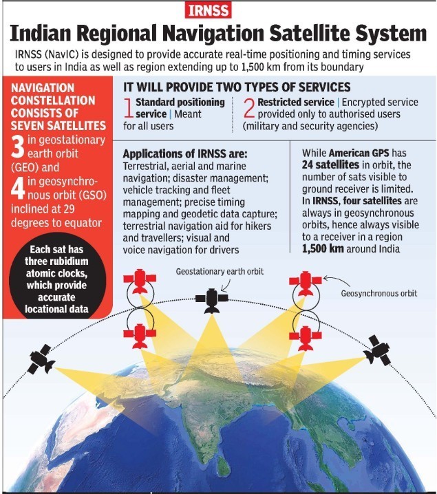
- This will position information similar to GPS and GLONASS to assist in the navigation of ships in ocean waters within the area covered by 50°N latitude, 55°E longitude, 5°S latitude and 110°E longitude (approximately up to 1500 km from Indian boundary).
- It is a significant achievement of Ministry of Ports, Shipping and Waterways (MoPSW) and Indian Space Research Organisation (ISRO) towards “Atmanirbhar Bharat”.
IRNSS
- IRNSS is an independent regional navigation satellite system developed by India.
- It is designed to provide accurate position information service to assist in the navigation of ships in Indian Ocean waters.
https://www.pib.gov.in/PressReleasePage.aspx?PRID=1674483
Array
(
[0] => daily-current-affairs/indias-irnss-is-now-part-of-world-wide-radio-navigation-system
[1] => daily-current-affairs
[2] => indias-irnss-is-now-part-of-world-wide-radio-navigation-system
)