Description
Disclaimer: Copyright infringement not intended.
Context: India announced that it wants to modify the 62-year-old Indus Waters Treaty (IWT) with Pakistan, citing what it called Pakistan’s “intransigence” in resolving disputes over the Kishenganga and Ratle hydropower projects, both in Jammu and Kashmir.
Details:
- India also protested Pakistan’s “unilateral” decision to approach a court of arbitration at The Hague.
- The decision to issue notice to Pakistan, with a request for a response within 90 days, is a major step and could lead to the unravelling and renegotiation of the water-sharing treaty.
- The treaty is often seen as a rare example of India-Pakistan consensus, at a time when the two nations have snapped trade and cultural exchanges, and most bilateral talks.
- Pakistan’s move to push the World Bank for a Court of Arbitration ran counter to the pre-existing channel of dispute resolution through a “neutral expert” appointed by the World Bank.
- Indian officials said the “parallel processes” instead of a “graded mechanism” had led to a stalemate, adding that India was left with no choice but to demand that Pakistan come to the table to negotiate amendments to the treaty.
Copyright infringement is not intended
About the treaty:
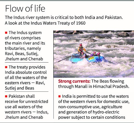
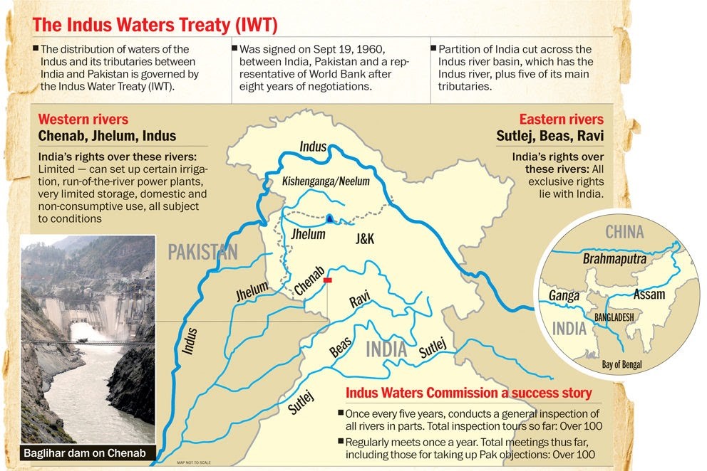
- The Indus Water Treaty (IWT) is a water-distribution treaty between India and Pakistan, arranged and negotiated by the World Bank, to use the water available in the Indus River and its tributaries. It was signed in Karachi on 19 September 1960 by Indian Prime Minister Jawaharlal Nehru and Pakistani President Ayub Khan.
- Under the Indus Water Treaty (IWT) signed between India and Pakistan in 1960, all the waters of the eastern rivers -- Sutlej, Beas, and Ravi -- amounting to around 33 million acre feet (MAF) annually is allocated to India for unrestricted use.
- The waters of western rivers – Indus, Jhelum, and Chenab – amounting to around 135 MAF annually have been assigned largely to Pakistan.
- India is permitted to construct the run of the river plants on western rivers with limited storage as per criteria specified in the treaty.
- Under the provisions of Article VIII(5) of the Indus Waters Treaty, the Permanent Indus Commission is required to meet at least once a year, alternately in India and Pakistan
Copyright infringement is not intended
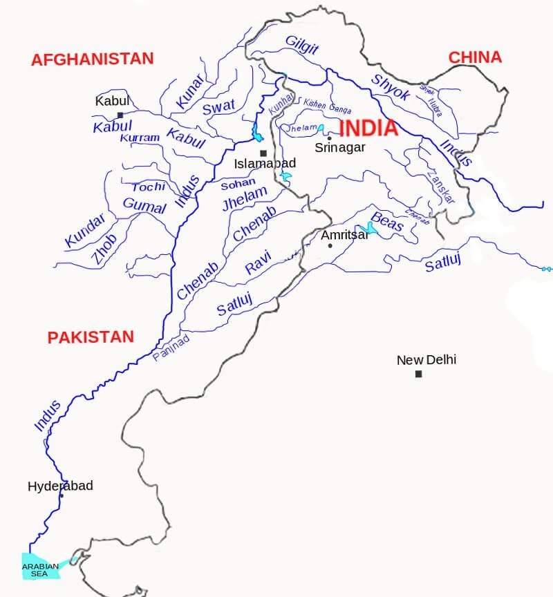
The Indus is one of the most important drainage systems of the subcontinent of India. It has a length of 2880 Km, of which 709Km lies in India. The State-wise distribution of the drainage area is given below:
Sr.No State Drainage area (sq.km)
- Jammu and Kashmir 193,762
- Himachal Pradesh 51,356
- Punjab 50,304
- Rajasthan 15,814
- Haryana 9,939
- Chandigarh 114
Total 321,289
- The Indus is the western most River system in the subcontinent. Jhelum, Chenab, Ravi, Beas and Satluj are its main tributaries.
- The Indus originates from the Bokhar Chu (glacier) in northern slopes of Mt. Kailash (6714m). It drains the largest number of glaciers and mountain slopes of the Karakorum, Ladakh, Zaskar and Himalayan Ranges.
- Originating from the Kailash Mountain, it flows in a constricted valley north-westward through Tibet, where it is called as Singi Khamban or Lion’s mouth.
- In Ladakh it follows a long nearly straight course between the Ladakh range and the Zaskar range.
- In the first 480 km, it flows along the northern flank of the Zaskar range over a flat country at heights over 3200 m where it receives River Zaskar below Leh.
- Suru and Dras are the other left bank tributaries which join the Indus near Kargil. Moving north-westward, the Indus is joined by the Shyok-Nubra tributaries.
- These tributaries arise from the Siachin Glacier (Karakoram Range). At Skardu, at a little distance below the Shyok, the Shigar River meets River Indus.
- Gilgit is another important tributary which comes from the west to join Indus. Downward; the Indus crosses the central Himalayan range through a huge synclinal gorge.
- The River passes by the Nanga-Parvat and turns south-west to enter Pakistan.
.jpeg)
Jhelum River Basin:
- The River Jhelum formed by the water of a spring viz. Cheshma Verinag situated at the foot hills accommodating Banihal pass in the south eastern corner of the Kashmir Valley and flows towards west through the Kashmir Valley.
- In the course up to Anantnag town three major tributaries viz. Sandran River, Bringi River and Arapath joins on its right flank.
- Lidder a biggest River of all the effluents that forms the head waters of River Jhelum.
- Jhelum River receives two small streams viz. Watlara and Arapal on the right flank, and three small streams viz. Rambiara, Sasara, Romuhi on the left flank.
Chenab River Basin:
- The river Chenab (or Chandra Bhaga) is formed after the two streams; the Chandra and the Bhaga merge with each other at Tandi.
- The Chandra and the Bhaga originate from the South-West and North West faces of Barelacha pass respectively in the Himalayan canton of Lahuland Spiti valley in Himachal Pradesh.
- The united stream, known as Chandra Bhaga (Chenab) receives its first major tributary the Miyar Nallah on the right bank
- It is joined on the right bank by its biggest tributary, the Marusudar at Bhandarkot.
- Niru Nallah joins the Chenab River on its left Bank.
- It enters into Sialkot district of Pakistan.
- The total length of the river from confluence of Chandra and Bhaga to Akhnoor is about 410 km.
Ravi River:
- The Ravi River originates in the Himalayas in the Chamba district of Himachal Pradesh.
- The River drains a total catchment area of 14,442 sq.km in India after flowing for a length of 725 km.
- Flowing westward, it is hemmed by the PirPanjal and Dhauladhar ranges, forming a triangular zone.
- It follows a north-westerly course and is a perennial River. It is the smallest of the five Punjab Rivers.
- It flows through Barabhangal, Bara Bansu and Chamba districts.
Satluj River:
- The Satluj River, which is one of the major five rivers of the erstwhile Punjab, is a main source of water for Himachal Pradesh, Punjab, Haryana, Delhi & Rajasthan.
- This river is a tributary of the river Indus & originates near Mansarover Lake in Tibet at an altitude 4572 m.
- Satluj is joined by the river Spiti at flows through 320 kms from border through Shipkilla, Pooh, Powari, Tapri, Karcham, Nathpa, Rampur, Sunni and Dehar to meet Gobindsagar reservoir (Bhakra) near Bilaspur in Himachal Pradesh.

https://epaper.thehindu.com/Home/ArticleView


