Disclaimer: Copyright infringement not intended.
Context
INDIA CHINA BORDER DISPUTE DECODED: https://www.iasgyan.in/blogs/india-china-border-dispute-decoded
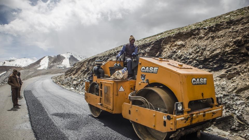
A number of infrastructure developments have been initiated on both sides since the standoff.
READ ALL ABOUT PANGONG TSO LAKE: https://www.iasgyan.in/daily-current-affairs/pangong-tso-41-20
Infrastructural Developments in the Border Region: By India
|
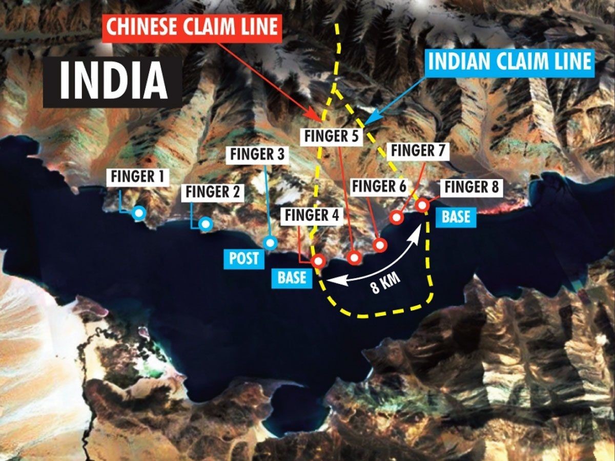
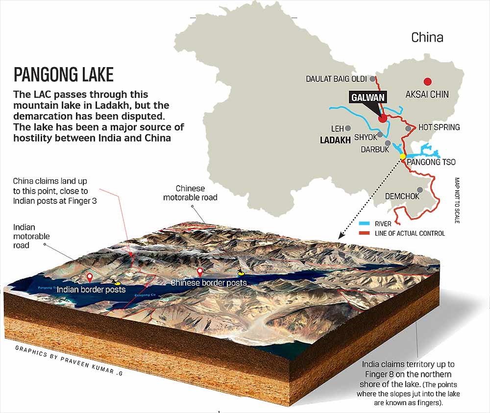
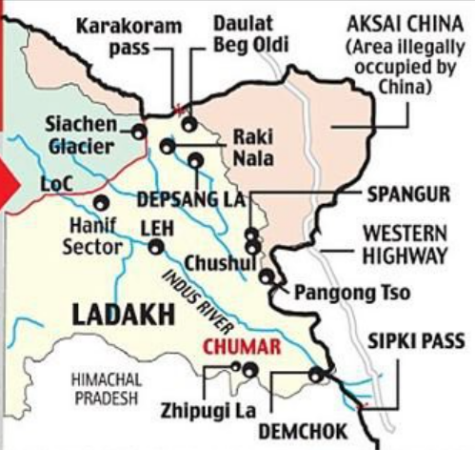
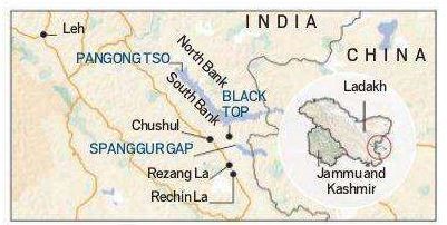
FINGERS OF PANGONG TSO LAKE India holds one-third of the 135 km-long boomerang-shaped Pangong lake. Mountain spurs of the Chang Chenmo range jutting down into the glacial lake are referred to as ‘Fingers’ in military parlance. The north bank of the lake is divided into 8 fingers. India has claimed its territory till Finger 8 and China disputes its claims till Finger 4. There have been regular face-offs between the two armies between Finger 4 and Finger 8, a distance of eight kilometres, on the northern bank of the lake. CLAIMS PERTAINING TO PANGONG TSO LAKE FINGERS India has always held the lake till Finger 4, but its claims run till Finger 8, which is where the Indian perception of the Line of Actual Control (LAC) lies, as reiterated by India on several occasions. The north bank, which has much higher differences in the perception of the LAC than the south bank, was the initial site of the clashes in early May 2020, with tensions flaring up in the Kailash ranges in July and August 2020. The Indian Army has a permanent position near Finger 3, while the Chinese have a base east of Finger 8.
|
|
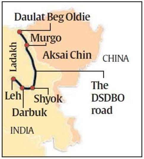
DARBUK–SHYOK–DBO ROAD The Darbuk–Shyok–DBO Road also called the Sub-Sector North Road, is a strategic all-weather road in eastern Ladakh , close to the Line of Actual Control with China. It connects Ladakh's capital city Leh, via the villages of Darbuk and Shyok at southern Shyok River Valley, with the Daulat Beg Oldi (DBO) post near the northern border. The 220-km long section between Shyok and DBO was constructed between 2000 and 2019 by India's Border Roads Organisation (BRO). The DS-DBO Road has reduced the travel time between Leh to DBO from 2 days to 6 hours. In January 2023, BRO announced that it is constructing the DSDBO tunnel on this route.
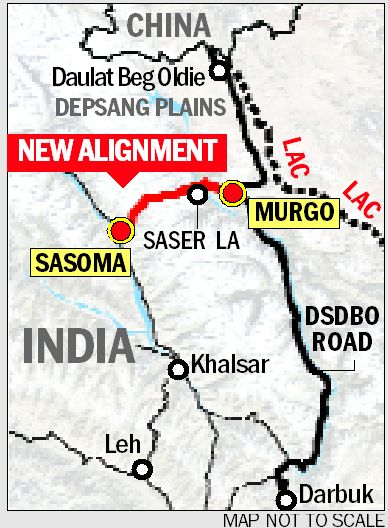
SASER PASS Sasser Pass is high mountain pass located on the route from Leh in Ladakh to Yarkand in the Tarim Basin. This mountain pass with an elevation of 5411 meters leads from the head of the Nubra Valley into the upper Shyok valley to Karakoram Pass. Sasser Pass is also known as Saser Pass or Saser La pass. Saser Pass is located at a distance of 37 km southeast of the Siachen Glacier area that the 1972 Simla Agreement between India and Pakistan failed to define clearly. Earlier this place was too icy for the Bactrian camels, which were the usual pack of animals to the north of the Saser Pass.
|
READ ABOUT SELA TUNNEL: https://www.iasgyan.in/daily-current-affairs/sela-tunnel
|
Nechiphu Tunnel Nechiphu Tunnel is located on the Balipara-Charduar-Tawang (BCT) road in West Kameng district of Arunachal Pradesh. The 450m-long tunnel, bypasses the existing road, and it is D-shaped and comprise two lanes of 3.5m width each. Another 1.8 km-long tunnel is also being constructed on the BCT road and both will reduce distance to the area bordering China by 10km. |
Chinese construction
|
KHURNAK FORT The Khurnak Fort is a ruined fort on the northern shore of Pangong Lake, which spans eastern Ladakh in India and Rutog County in the Tibet region of China. The area of the Khurnak Fort is disputed by India and China, and has been under Chinese administration since 1958. Though the ruined fort itself is not of much significance, it serves as a landmark denoting the middle of Pangong Lake. The fort lies at the western edge of a large plain formed as the alluvial fan of a stream known as Chumesang, which falls into Pangong Lake from the north. The plain itself is called Ote Plain locally, but is now generally called the Khurnak Plain. |
|
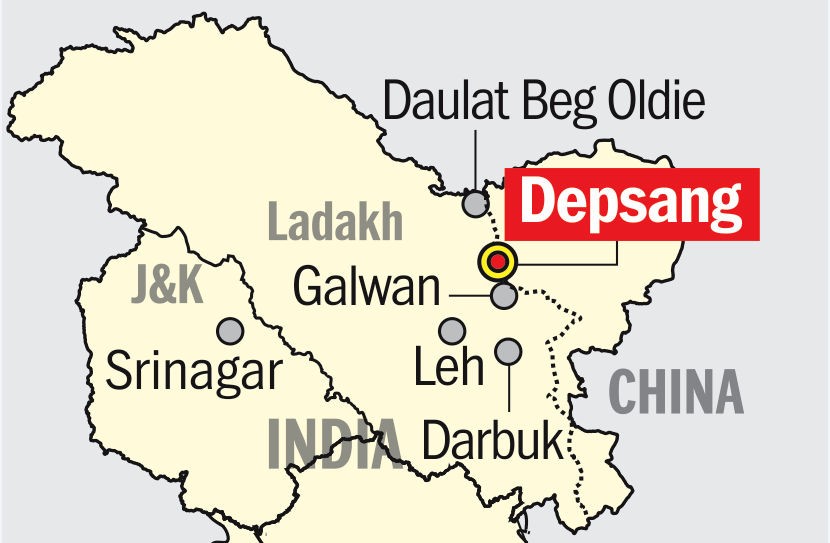
DEPSANG PLAINS The Depsang Plains, a high-altitude gravelly plain in the northwest portion of the disputed Aksai Chin region of Kashmir, divided into Indian and Chinese administered portions by a Line of Actual Control. India controls the western portion of the plains as part of Ladakh, while the eastern portion is controlled by China and claimed by India. The Line of Control with Pakistan-administered Gilgit-Baltistan is 80 kilometers west of the Depsang Plains with the Siachen Glacier in-between. Ladakh's traditional trade route to Central Asia passed through the Depsang Plains, with the Karakoram Pass lying directly to its north. The Depsang plains are located in the north-western Aksai Chin. They are bounded on the north by the valley of the Chip Chap River and on the west by the Shyok River. On the east they are bounded by low hills of the Lak Tsung range, which separate them from the basin of the Karakash River. In the south, the Depsang Plains proper end at the Depsang La pass, but in common parlance, the Depsang region is taken to include the mountainous region to the south of it, including the "Depsang Bulge". The Karakoram Pass is located to the north of the Depsang Plains while the Lingzi Thang plains lie to the southeast. On the west is the southern part of the Rimo glacier, the source of the Shyok River.
DEMCHOK Demchok is a village and military encampment in the Indian-administered Demchok sector that i s disputed between India and China. It is administered as part of the Nyoma tehsil in the Leh district of Ladakh by India, and claimed by China as part of the Tibet Autonomous Region. The Line of Actual Control (LAC) passes along the southeast side of the village, along the Charding Nullah (also called Demchok River and Lhari stream) which joins the Indus River near the village. Across the stream, less than a kilometre away, is a Chinese-administered Demchok village.
|
|
PRACTICE QUESTION Q. Consider the following statements: 1.The Darbuk–Shyok–DBO Road also called the Sub-Sector North Road, is a strategic all-weather road in Kashmir, close to the Line of Actual Control with China. 2.The Khurnak Fort is a ruined fort on the northern shore of Pangong Lake, which spans eastern Ladakh in India and Rutog County in the Tibet region of China. 3.Sasser Pass is high mountain pass located on the Balipara-Charduar-Tawang (BCT) road in West Kameng district of Arunachal Pradesh. 4.The Depsang plains are bounded on the north by the valley of the Chip Chap River and on the west by the Shyok River. Which of the above statements is/are correct? (a) 1 and 3 only (b) 2, 3, and 4 only (c) 2 and 4 only (d) None of the above. Correct Answer: (c) 2 and 4 only |


© 2025 iasgyan. All right reserved