Disclaimer: Copyright infringement not intended.
Context
- The International Seabed Authority's member nations agreed on a two-year roadmap for the adoption of deep-sea mining regulations.
International Seabed Authority
About
- The International Seabed Authority is an international intergovernmental organization.
- The Authority operates as an autonomous international organization with its own Assembly, Council, and Secretariat.
Establishment
- It came into existence on 16 November 1994.
- It was established under the 1982 United Nations Convention on the Law of the Sea and the 1994 Agreement relating to the Implementation of Part XI of the United Nations Convention on the Law of the Sea.
Headquarters
- The Authority, which has its headquarters in Kingston, Jamaica.
Members
- The Authority has 167 members and the European Union, and is composed of all parties to the United Nations Convention on the Law of the Sea.
Mission
The ISA's dual mission is to –
- Authorize and control the development of mineral-related operations in the international seabed considered the "Common Heritage of All Mankind" and also
- Protect the ecosystem of the seabed, ocean floor, and subsoil in "The Area" beyond national jurisdiction.
|
"Common Heritage of All Mankind"
- Under UNCLOS, Part XI, Section 2. "The Area and its resources are the common heritage of mankind."
- As a result, ISA must ensure that activities in the Area are undertaken only for peaceful purposes and for the benefit of all humankind, with economic benefits shared equitably and special consideration given to the needs of developing nations.
Jurisdiction
- UNCLOS defines the international seabed area—the part under ISA jurisdiction—as "the seabed and ocean floor and the subsoil thereof, beyond the limits of national jurisdiction" UNCLOS outlines the areas of national jurisdiction as a "12 nautical-mile territorial sea; an exclusive economic zone of up to 200 nautical miles and a continental shelf", unless a nation can demonstrate that its continental shelf is naturally prolonged beyond that limit, in which case it may claim up to 350 nautical miles (650 km).
- ISA has no role in determining this boundary. Rather, this task is left to another body established by UNCLOS, the Commission on the Limits of the Continental Shelf, which examines scientific data submitted by coastal states that claim a broader reach.
|
Main Objective
- The ISA is to safeguard the international deep sea, the waters below 200 meters or 656 feet, where photosynthesis is hampered by inadequate light.
Mandate
- Governing approximately half of the total area of the world's oceans, the ISA is to exercise oversight of activities that might threaten biological diversity and harm the marine environment.
- The Authority operates by contracting with private and public corporations and other entities authorizing them to explore, and potentially exploit, specified areas on the deep seabed for mineral resources, such as cobalt, nickel and manganese.
Operations
- Since the ISA's inception in 1994, the Authority has approved over two dozen ocean floor mining exploration contracts in the Atlantic, Pacific and Indian Oceans, with the majority of contracts for exploration in the Clarion-Clipperton Zone between Hawaii and Mexico. This is where polymetallic nodules contain copper, cobalt and other minerals used to power electric batteries.
Note: To date, the Authority has not authorized any commercial mining contracts as it deliberates over regulations amid global calls for a moratorium on deep sea mining.
Governance
- Along with a Secretary-General, two principal organs establish the policies and govern the work of the Authority: The Assembly, in which all UNCLOS parties are represented, and a 36-member Council elected by the Assembly.
Funding
- The ISA is funded by UNCLOS members.

United Nations Convention on the Law of the Sea (UNCLOS)
About
- The United Nations Convention on the Law of the Sea (UNCLOS), also called the Law of the Sea Convention or the Law of the Sea Treaty, is an international agreement that establishes a legal framework for all marine and maritime activities.
Members
- 167 countries and the European Union are parties to it.
Origin
- The convention resulted from the third United Nations Conference on the Law of the Sea (UNCLOS III), which took place between 1973 and 1982. UNCLOS replaced the four treaties of the 1958 Convention on the High Seas.
Establishment
- UNCLOS came into force in 1994, a year after Guyana became the 60th nation to ratify the treaty.
High Seas Treaty
- In 2023, an agreement was reached on a High Seas Treaty to be added as an instrument of the convention, to protect ocean life in international waters.
- This would provide measures including Marine Protected Areas and environmental impact assessments.
READ ABOUT THE HIGH SEAS TREATY:
https://www.iasgyan.in/ias-gazette-magazine/perspectivehigh-seas-treaty
https://www.iasgyan.in/daily-current-affairs/un-high-seas-treaty-20
UNCLOS on Territorial Disputes
- UNCLOS does not deal with matters of territorial disputes or to resolve issues of sovereignty, as that field is governed by rules of customary international law on the acquisition and loss of territory.
UNCLOS Legal Framework
- The United Nations Sustainable Development Goal 14 has a target regarding the conservative and sustainable use of oceans and their resources in line with the UNCLOS legal framework.
Maritime Zones
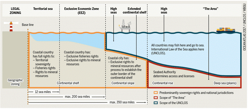
The convention set the limit of various areas, measured from a carefully defined baseline. (Normally, a sea baseline follows the low-water line, but when the coastline is deeply indented, has fringing islands or is highly unstable, straight baselines may be used.) The areas are as follows:
Internal waters:
- Covers all water and waterways on the landward side of the baseline.
- The coastal state is free to set laws, regulate use, and use any resource.
- Foreign vessels have no right of passage within internal waters.
- A vessel in the high seas assumes jurisdiction under the internal laws of its flag state.
Territorial Sea:
- Up to 12 nautical miles (22 kilometres; 14 miles) from the baseline, the coastal state is free to set laws, regulate the use, and use any resource. The coastal State enjoys Sovereign rights and sovereign jurisdiction within its territorial sea.
- Vessels were given the right of innocent passage through any territorial sea, with strategic straits allowing the passage of military craft as transit passage, in that naval vessels are allowed to maintain postures that would be illegal in the territorial sea.
"Innocent passage" is defined by the convention as passing through waters in an expeditious and continuous manner, which is not "prejudicial to the peace, good order or the security" of the coastal state.
- Fishing, polluting, weapons practice, and spying are not "innocent", and submarines and other underwater vehicles are required to navigate on the surface and to show their flag.
- Nations can also temporarily suspend innocent passage in specific areas of their territorial sea if doing so is essential for the protection of their security.
Archipelagic waters:
- The convention set the definition of "Archipelagic States" in Part IV, which also defines how the state can draw its territorial borders.
- A baseline is drawn between the outermost points of the outermost islands, subject to these points being sufficiently close to one another. All waters inside this baseline are designated "Archipelagic Waters".
- The state has sovereignty over these waters mostly to the extent it has over internal waters, but subject to existing rights including traditional fishing rights of immediately adjacent states.
- Foreign vessels have the right to innocent passage through archipelagic waters, but archipelagic states may limit innocent passage to designated sea lanes.
Contiguous zone:
- Beyond the 12-nautical-mile (22 km) limit, there is a further 12 nautical miles (22 km) from the territorial sea baseline limit, the contiguous zone.
- Here a state can continue to enforce laws in four specific areas (customs, taxation, immigration, and pollution) if the infringement started or is about to occur within the state's territory or territorial waters. This makes the contiguous zone a hot pursuit area.
.jpg)
Exclusive economic zones (EEZs):
- These extend 200 nmi (370 km; 230 mi) from the baseline. Within this area, the coastal nation has sole exploitation rights over all natural resources.
- In casual use, the term may include the territorial sea and even the continental shelf.
- The EEZs were introduced to halt the increasingly heated clashes over fishing rights, although oil was also becoming important. The success of an offshore oil platform in the Gulf of Mexico in 1947 was soon repeated elsewhere in the world, and by 1970 it was technically feasible to operate in waters 4,000 meters (13,000 ft) deep.
- Foreign nations have the freedom of navigation and overflight, subject to the regulation of the coastal states.
- Foreign states may also lay submarine pipes and cables.
Continental shelf:
- The continental shelf is defined as the natural prolongation of the land territory to the continental margin's outer edge, or 200 nautical miles (370 km) from the coastal state's baseline, whichever is greater.
- A state's continental shelf may exceed 200 nautical miles (370 km) until the natural prolongation ends. However, it may never exceed 350 nmi (650 km; 400 mi) from the baseline; nor may it exceed 100 nmi (190 km; 120 mi) beyond the 2,500 metres (8,200 ft) isobath (the line connecting the depth of 2 500 m).
- Coastal states have the right to harvest mineral and non-living material in the subsoil of its continental shelf, to the exclusion of others.
- Coastal states also have exclusive control over living resources "attached" to the continental shelf, but not to creatures living in the water column beyond the exclusive economic zone.
The area outside these areas is referred to as the "high seas" or simply "the Area”.
- Aside from its provisions defining ocean boundaries, the convention establishes general obligations for safeguarding the marine environment and protecting freedom of scientific research on the high seas and also creates an innovative legal regime for controlling mineral resource exploitation in deep seabed areas beyond national jurisdiction, through an International Seabed Authority and the common heritage of mankind principle.
- Landlocked states are given a right of access to and from the sea, without taxation of traffic through transit states.
READ ALL ABOUT DEEP SEA MINING:
https://www.iasgyan.in/daily-current-affairs/deep-sea-mining
https://www.iasgyan.in/daily-current-affairs/deep-sea-mining-31
|
PRACTICE QUESTION
Q. Consider the following statements.
1. A state's continental shelf may exceed 200 nautical miles until the natural prolongation ends.
2. The United Nations Convention on the Law of the Sea (UNCLOS) is an international agreement that establishes a legal framework for all marine and maritime activities.
3. The main objective of the International Seabed Authority is to safeguard the international deep sea, the waters below 200 meters or 656 feet, where photosynthesis is hampered by inadequate light.
4. Vessels are given the right of innocent passage through any territorial sea and fishing is considered as "innocent".
Which of the above statements is/are incorrect?
(a) 1 only
(b) 2 and 3 only
(c) 4 only
(d) None of the above.
Correct Answer: (c) 4 only
|
https://www.thehindu.com/news/international/nations-aim-to-ink-deep-sea-mining-rules-by-2025/article67110597.ece


