Description
Disclaimer: Copyright infringement not intended.
Context
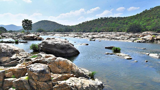
- The water level of Jhelum and its tributaries have fallen drastically owing to dry weather conditions prevalent since the last month in Kashmir Valley.
- As of September 12 at 9 p.m., the water level of Jhelum River at Sangam measured minus 0.01 feet, at Ram Munshi Bagh it was flowing at 2.20 feet, and at Asham 1.55 feet.
Details
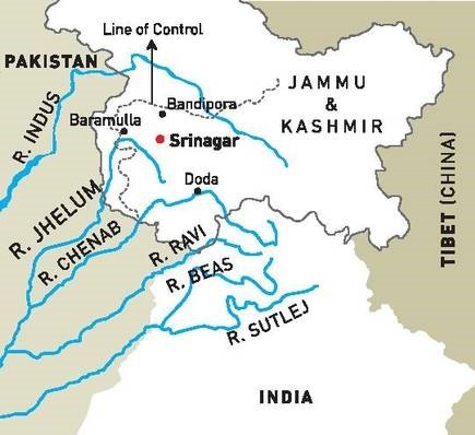
The Jhelum River:
- It is a river that runs between India and Pakistan.
- It is an Indus River tributary.
- The Jhelum (Vyeth in Kashmiri, Vetesta in Sanskrit, and Hydaspes in Greek) is the valley's principal stream.
- It is the largest and westernmost of Punjab's five rivers, flowing through the Jhelum District in Pakistan's Punjab province.
Some other facts
- It begins in the Verinag Spring in Anantnag, at the foot of the Pir Panjal range in the Kashmir Valley.
- It then passes through Srinagar and Wular Lake before entering Pakistan.
- On its way to Pakistan, the river carves a steep, tight valley.
- It merges with the Chenab River at Trimmu in Pakistan.
- It is approximately 725 kilometers (450 mi) long in total.
Tributaries of Jhelum River
- The major tributary of the Jhelum is the Kishenganga (Neelum) River, which joins near Muzaffarabad and flows into Pakistan's Punjab province.
- The Kunhar River is the river's second major tributary, connecting Pakistan-occupied Kashmir (PoK) and Pakistan via the Kohala Bridge of Kanghan Valley.
- Sandran River, Bringi River, Arapath River, Watlara River, Lidder River, and Veshaw River are also tributaries.
Understanding Jhelum River's Seasonal Fluctuations
- During the spring season, the Jhelum and its tributaries experience the highest flows as the snow in the upper regions begins to melt due to rising temperatures.
- This rapid snowmelt typically continues until summer.
- While occasional monsoon showers may help sustain water levels until September, even excess rainfall during this southwest monsoon season cannot guarantee a stable water supply in the autumn.
- Autumn is the season when Kashmir witnesses reduced monsoon activity and the impact of Western Disturbances is minimal.
- Moreover, as temperatures in higher altitudes drop below freezing point, the melt-off from glaciers slows down, further contributing to lower water levels in the Jhelum and its tributaries.

Other Indus River System
The Chenab River
- Another important tributary of the Indus River System is the Chenab River, also known as Asskini Chandrabhaga.
- It forms where the Chandra and Bhaga rivers meet in Himachal Pradesh's Western Himalayas.
- The Baralacha La Pass is the principal source of water for these streams.
- The Chenab River flows through Himachal Pradesh and Jammu & Kashmir before joining the Indus.
- It is the Indus River System's greatest tributary.
The River Ravi
- Following that is the Ravi River, commonly known as Iravati or "The River of Lahore."
- The Ravi River rises near the Rohtang Pass in the Himachal Pradesh district of Chamba.
- It meets the Chenab River in Pakistan after traveling approximately 720 kilometers.
- Between the Pir Panjal and Dhauladhar Ranges, the Ravi passes through Shahdara Bagh, which includes the tombs of Jahangir and Noor Jahan.
The Beas River
- The Beas River is an important contributor to the Indus River System.
- It begins its trip in the Beas Kund in Himachal Pradesh's Rohtang La pass.
- The Beas River flows for around 470 kilometers before joining the Satluj River in Punjab.
- As a result, the Beas River flows through Punjab and Himachal Pradesh in India.
The Satluj River
- The Satluj River is an important tributary of the Indus River.
- It has the longest course of any tributary in the Indus River System.
- The Rakkas Lake, sometimes known as Lake Rakshastal, is located in
- The Satluj River then runs through India's Himachal Pradesh and Punjab states before entering India via the Shipki La Pass and joining the Chenab River.
- This River is 1,450 kilometers long in total, with 1,050 kilometers located within Indian territory.
The Historical Importance of the Indus River System
- The Indus River System has a rich historical history, as it was the origin of the Indus Valley Civilization, one of the world's earliest urban civilizations.
- This ancient civilization existed along the banks of the Indus and its tributaries approximately 3300 BCE.
- Archaeological findings have revealed precise town design, advanced drainage systems, and a complex trading network that stretched to Mesopotamia.
The Economic Value of the Indus River System
- For millennia, the fertile alluvial plains watered by the Indus River System have facilitated cultivation.
- The river and its tributaries' waters are used for irrigation via a vast network of canals and dams.
- The region is a key producer of products like rice, wheat, cotton, and sugarcane, which contribute significantly to the economies of the system's member countries.
Hydropower Potential of the Indus River System
- Aside from its agricultural importance, the Indus River System has significant hydropower potential.
- Along its path, dams and hydroelectric projects have been built to generate electricity and give energy to industry and households.
- In Pakistan, projects like the Tarbela Dam and the Mangla Dam are colossal examples of harnessing the river's power for economic growth.
Environmental Issues in the Indus River System
- Over-extraction, pollution, and habitat deterioration pose severe difficulties to the Indus River System.
- Rapid population increase, industrialization, and poor waste management techniques all contribute to the contamination of these essential water sources.
- Balancing economic growth goals with environmental conservation is still a major challenge.
Conflict and International Cooperation on the Indus River System
- Several tributaries of the Indus River flow through multiple countries, resulting in complex water-sharing arrangements and sometimes disputes.
- The World Bank-mediated Indus Waters Treaty of 1960 defines the distribution of river waters between India and Pakistan.
- The achievement of the pact in preserving relative stability in water-sharing illustrates the importance of international cooperation in managing shared resources.
.jpg)
The Impact of Climate Change on the Indus River System
- Climate change threatens the Indus River System by influencing water supply, glacial melt, and monsoon patterns.
- Changes in precipitation patterns and retreating glaciers in the Himalayas could upset the delicate balance of water supply, providing problems for water resource management and agricultural sustainability.
- The Indus River System, which spans millennia and civilizations, is a tribute to the complex interaction that humans have with their environment.
- It has seen civilizations rise and fall, economies evolve, and the problems of industrialization.
- As nations deal with development and conservation imperatives, the Indus River System stands as a symbol of resilience, adaptation, and the interconnectivity of all species along its banks.
|
PRACTICE QUESTION
Dry weather conditions in Kashmir valley have wide-ranging impacts on Socio-Economic life in the valley. Substantiate
|