Description
Disclaimer: Copyright infringement not intended.
Context
Communities worldwide now have access to a powerful tool to increase their awareness of landslide hazards, thanks to NASA and the Pacific Disaster Center.
Details
What is Landslide?
- Landslides are more widespread than any other geological event and can occur anywhere in the world.
- They occur when large masses of soil, rocks, or debris move down a slope due to a natural phenomenon or human activity.
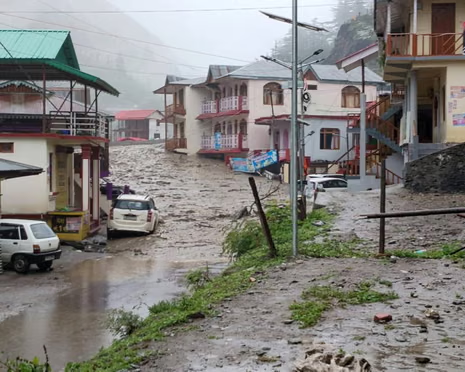
- Mudslides or debris flows are also a common type of fast-moving landslide.
Landslides can accompany heavy rains or follow droughts, earthquakes or volcanic eruptions. Areas most vulnerable to landslides include:
- steep terrain, including areas at the bottom of canyons;
- land previously burned by wildfires;
- land that has been modified due to human activity, such as deforestation or construction;
- channels along a stream or river;
- any area where surface runoff is directed or land is heavily saturated.
Types of Landslides
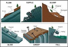
Landslides are classified into several types based on their movement characteristics:
- Slides: Slides are soil or rock motions that occur along a rupture surface or a zone of weakness. They are further subdivided into rotational slides, which have a curved rupture surface, and translational slides, which have a planar rupture surface.
- Flows: Flows are motions of soil or rock containing a considerable amount of water, causing the bulk to flow like a fluid. Depending on the material and the velocity of movement, they are further classified as earth flows, debris flows, mudflows, and creep.
- Spreads: Spreads are soil or rock movements that involve lateral extension and fracture of the bulk. They are typically induced by material liquefaction or plastic deformation.
- Topples: Topples are soil or rock movements that involve forward rotation and free-fall of the mass from a vertical or nearly vertical cliff or slope.
- Falls: Falls are soil or rock movements that detach from a steep slope or cliff and descend via free-fall, bouncing, or rolling.
Natural Causes of Landslides
- Climate: Long-term climate changes may have a substantial impact on soil stability.
- Earthquakes: Seismic activity has historically led to landslides around the world. When tectonic plates shift, the soil beneath them does as well.
- Weathering: Weathering is the natural process of rock deterioration that results in weak, landslide-prone materials.
- Erosion: Erosion caused by periodic running water, such as streams, rivers, wind, currents, ice, and waves, destroys slope support, making landslides more likely.
- Volcanoes: Volcanic eruptions can trigger landslides. The stratovolcano is a typical example of a volcano responsible for most landslides across the globe.

Human causes of landslides
- Mining: Mining activities that involve blasting techniques dramatically amplify landslides. The vibrations from the explosives have the potential to damage the soil in other landslide-prone areas.
- Timber Harvesting: Clearcutting is a process of collecting timber that entails removing all old trees from the region. This procedure is dangerous since it eliminates the local mechanical root system totally.
Landslide Zones in India
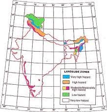
- Himalayan Mountain ranges and Hilly tracts of the North-eastern region:
-
- High seismicity due to proximity to plate boundaries,
- Young and rugged topography,
- unstable rock conditions
- heavy downpours
- As part of developing activities, there is a lot of anthropogenic influence.
- Western Ghats:
-
- Overburdening of steep hill slopes
- Rainfall at a high intensity.
- Nilgiris Hills:
-
- Rainfall with a high intensity and a long duration
Consequences of Landslides
- Infrastructure disruption: While landslides have a very small and localized area of direct influence, roadblocks, railway line destruction, and channel clogging caused by rock falls have far-reaching consequences.
- River Channel Diversion: River channel diversion caused by landslides can result in flooding and loss of lives and property.
- Difficult Spatial Interaction: It also makes spatial interaction difficult, unsafe, and expensive, which has a negative impact on development operations in these locations.
Mitigation of Landslides
Structural Measures:
- Retaining Walls: By preventing soil movement, retaining walls can offer support and stabilize slopes.
- Slope Reinforcement: To reinforce the slope and increase its resistance to sliding, techniques such as soil nailing, ground anchors, and geosynthetics (e.g., geotextiles, geogrids) can be utilized.
- Drainage Systems: Effective drainage systems are essential for regulating water flow and lowering excess pore water pressure on slopes.
- Terracing: Terracing is the process of establishing a succession of level platforms or steps on slopes in hilly or mountainous areas.
- This approach breaks the slope into smaller portions, decreasing the possibility of large-scale landslides and encouraging soil conservation.
The Initiatives taken by the Government to mitigate the risk of landslides
- National Landslide Risk Management Strategy (2019) : This is a comprehensive paper that covers all aspects of landslide disaster risk reduction and management, including hazard mapping, monitoring, early warning systems, awareness programs, capacity building, training, regulations, policies, landslide stabilization and mitigation, and so on.
- Landslide Risk Mitigation Scheme (LRMS): This is a scheme in the works that will provide financial support for site-specific landslide mitigation projects recommended by landslide-prone states, covering disaster prevention strategy, disaster mitigation, and R&D in monitoring critical landslides, resulting in the development of an early warning system and capacity-building initiatives.
- Flood Risk Mitigation Scheme (FRMS): This is another scheme in the works that includes activities such as pilot projects for the development of model multi-purpose flood shelters, the development of river basin-specific flood early warning systems, and the preparation of digital elevation maps for the preparation of inundation models in order to provide early warning to villagers for evacuation in the event of a flood.
- National Landslide and Snow Avalanche Guidelines: These are guidelines developed by the National Disaster Management Authority (NDMA) to guide operations aimed at decreasing the risk posed by landslides at all levels. Hazard assessment, vulnerability analysis, risk management, structural and non-structural measures, institutional processes, financial arrangements, community participation, and so on are all covered in the guidelines.
- India's Landslide Atlas: The Landslide Atlas of India is a publication that contains information about landslides throughout India's landslide provinces, as well as damage assessments for specific landslide areas. It was created by the National Remote Sensing Centre (NRSC), an ISRO institution.

What measures can be taken?
- First, states in high-risk zones, like as Himachal Pradesh and Uttarakhand, should exercise caution when pursuing disruptive projects.
- Before initiating mining or dam construction, proper environmental impact assessment standards must be met.
- Second, landslide micro-zoning approaches should be applied in hilly and other particularly vulnerable locations.
- Third, greater financing should be provided to landslide planning and mitigation authorities in order to increase disaster management capacity.
- Fourth, locally available trained persons should be mobilized to boost hazard reduction and public awareness activities.
- Fifth, mitigation strategies such as limiting agriculture to valleys and areas with moderate slopes, encouraging large-scale afforestation programs, and constructing water bunds should be supported.
|
PRACTICE QUESTION
Discuss the impact of landslides on the environment and human settlements. Suggest strategies for landslide risk reduction in hilly areas of India.
|


