Description
Copyright infringement is not intended
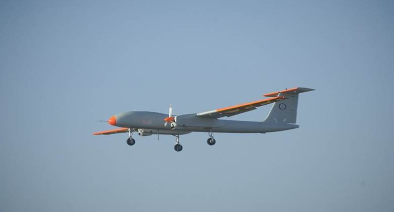
Context: China continues to expand its unmanned aerial vehicles (UAV) network and usage in areas close to the Line of Actual Control (LAC).
More about news:
- There is a significant increase in their use for a variety of tasks from intelligence, surveillance and target acquisition and reconnaissance (ISTAR) capabilities and logistics support.
- China is also increasingly deploying its advanced UAVs in Tibet close to the LAC.
- China is using drones for supplying vaccines in the border areas for effective last mile coverage at several locations and for supplying rations and other essential items to personnel deployed close on the border.
- Indigenous satellite communications: China is promoting the use of an indigenously built Tiantong satellite communication system to reduce its dependence on foreign origin sat phone communications.
India-China border issue:
- India-China-relations date back to more than 2,000 years ago. There have been cultural and economic ties between the two countries since ancient times.
- Relations between contemporary China and India have been characterized by border disputes, resulting in military conflicts like — the Sino-Indian War of 1962, the Chola incident in 1967, the 1987 Sino-Indian and the 2020 India-China skirmish.
- Relations between India and China have come under “severe stress” time and again in the last decade due to multiple border stand-offs along the Line of Actual Control.
Root cause of border dispute between India & China:
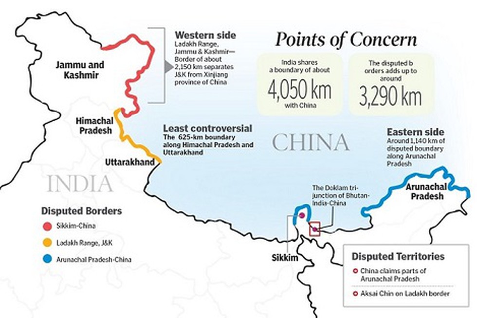
- The root cause lies in an ill-defined, 3,440km (2,100-mile)-long borderthat both countries dispute.Four states - Himachal Pradesh, Uttarakhand (erstwhile part of UP), Sikkim and Arunachal Pradesh and Union Territories of Ladakh (erstwhile state of Jammu & Kashmir) share a border with China.
- The Sino-Indian border is generally divided into three sectors namely: Western sector, Middle sector, and Eastern sector.
Western Sector
- In the western sector, India shares about a 2152 km border with China.
- It is between the union territory of Ladakh (erstwhile state of Jammu and Kashmir) and the Xinjiang province of China.
- The territorial dispute in the western sector is over Aksai Chin. India claims it as part of erstwhile Kashmir, while China claims it is part of Xinjiang.
- The dispute is said to be due to the failure of the British empire as it failed to demarcate a legal border between both countries. During the British rule in India two borderlines were proposed – Johnson’s line and McDonald line in 1865 and 1893 respectively.
- The Johnson’s line shows Aksai Chin in Ladakh i.e. under India’s control whereas McDonald Line places it under China’s control. India considers Johnson Line as a rightful national border with China, while on the other hand, China considers the McDonald Line as the correct border with India.
- The different claims and perceptions of LAC have led to an overlapping area, within that area lies a small zone which both the sides patrol causing clashes of the Indian and the Chinese army.
- At present, Line of Actual Control (LAC) is the line separating Indian areas of Ladakh from Aksai Chin. It is concurrent with the Chinese Aksai Chin claim line.
Middle Sector
- In the middle sector, India shares about 625km of the border with China. This is the only sector where the both countries have less disagreement. The border runs from Ladakh to Nepal.
- The states of Himachal Pradesh and Uttarakhand touch the border with Tibet in this sector.
Eastern Sector
- In the eastern sector, India shares a 1140km boundary with China. The boundary line is called McMahon Line runs from the eastern limit of Bhutan to a point near the Talu Pass at the trijunction of Tibet, India, and Myanmar.
- The majority of the territory of Arunachal Pradesh is claimed by China as a part of Southern Tibet.
- China considers the McMahon line illegal. McMahon proposed the line in the Simla Accord in 1914to settle the boundary between Tibet and India, and Tibet and China. Though the Chinese representatives at the meeting initialed the agreement, they subsequently refused to accept it.
Disputed areas along the LAC
- China claims about 90,000 sq km of India’s territory in the northeast, including Arunachal, while India says 38,000 sq km of land in China-occupied Aksai Chin should be a part of Ladakh.
- There are several disputed areas along the Line of Actual Control (LAC), including in Himachal, Uttarakhand and Sikkim.
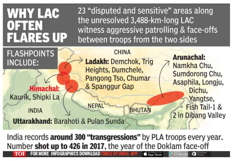
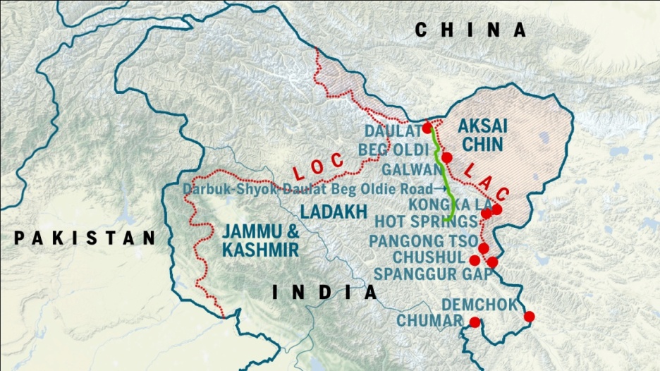
In Ladakh, the disputed areas include:
- Pangong Tso lake
- Galwan Valley, where Shyok and Galwan rivers meet
- Daulat Beg Oldi (DBO), a key northern region close to the Karakoram Pass.
- The Hot Springs-Gogra area of the LAC
- Demchok which is close to the southernmost part of the LAC in Ladakh.
- Chushul , located on the southern bank of Pangong Tso Lake, has an airstrip and is near Rezang La pass on the LAC.
- Spanggur Gap along the LAC has roads leading to it from either side. India’s Chushul-Demchok road in the area is a critical communication link.
- Samar Lungpa
- Trig Heights
- Chumar
- Dumchele
- Kongka La
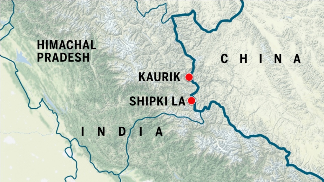
In Himachal Pradesh the disputed areas are-
- Kaurik
- Shipki La, an ancient trade route.
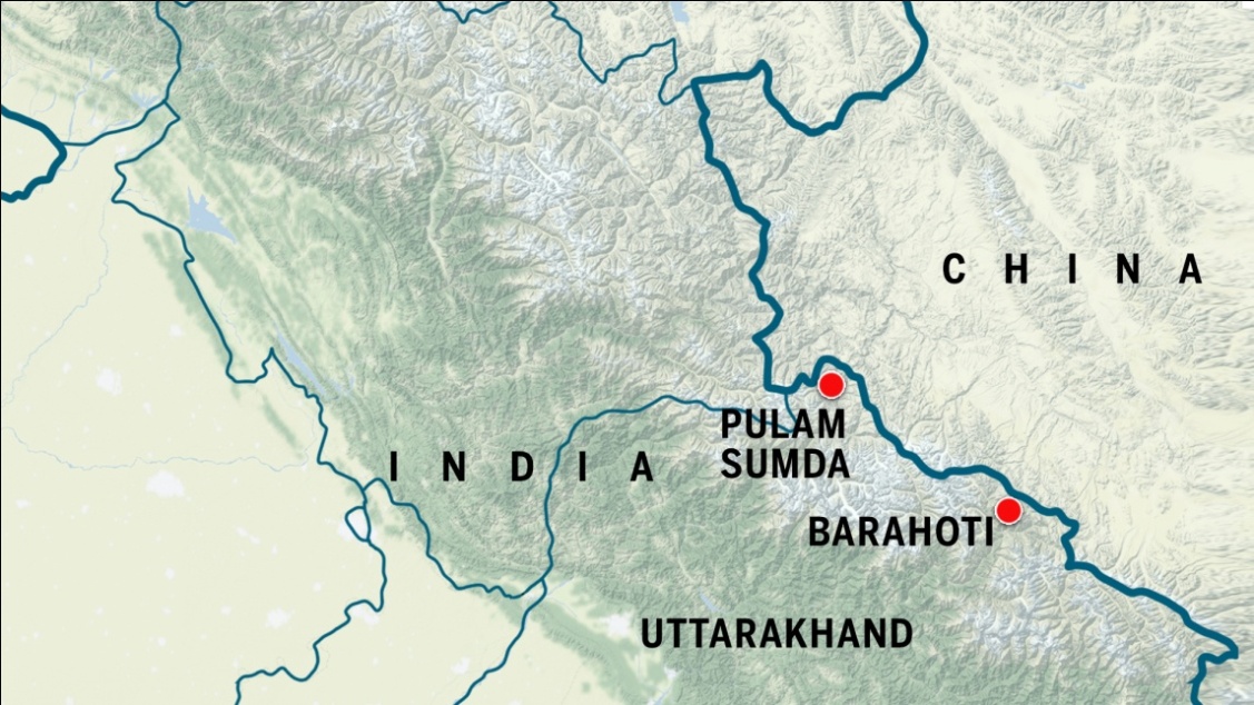
In Uttarakhand the disputed areas are-
- Pulam Sumda
- Barahoti Plains
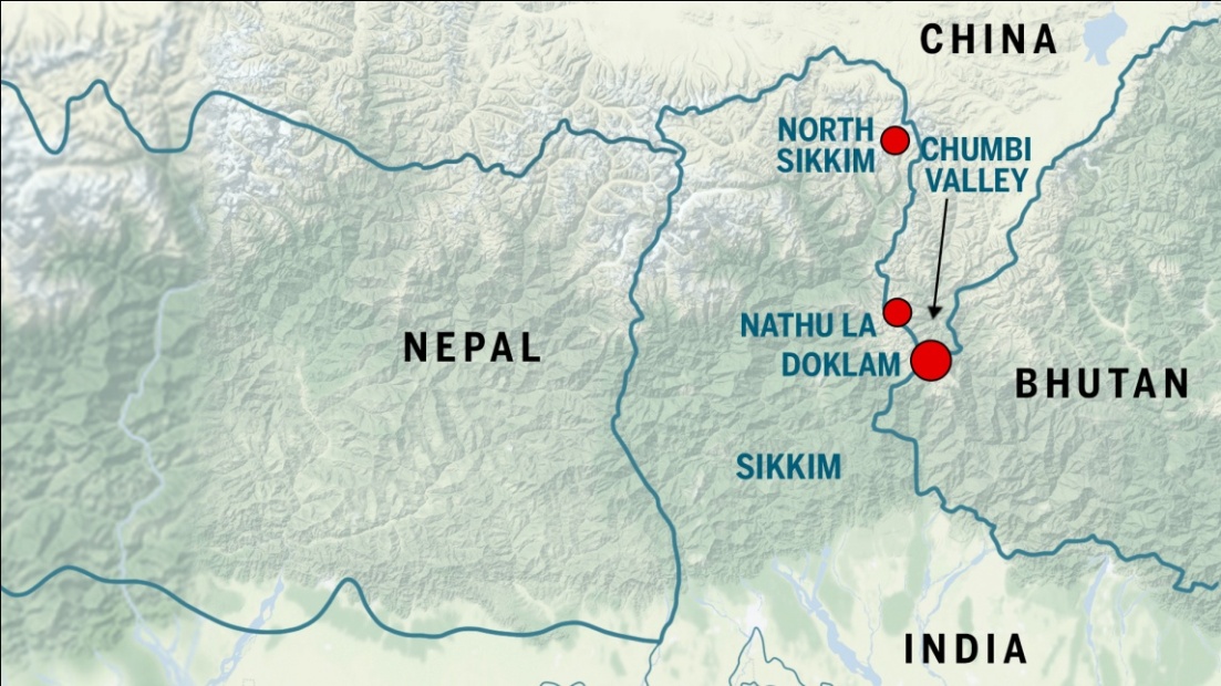
In Sikkim, the disputed areas include:
- North Sikkim, a high-altitude plain area that is snowbound.
- Chumbi Valley – It is a Tri-junction between India, China and Bhutan. Doklam is located in this region.
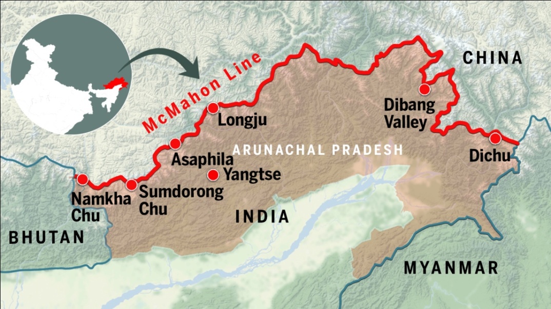
Disputed areas in Arunachal Pradesh include:
- Namkha Chu
- Sumdorong Chu
- Asaphila
- Longju
- Dichu
- Yangtse
- Fish Tail-1 & 2 in Dibang Valley
- Lamang
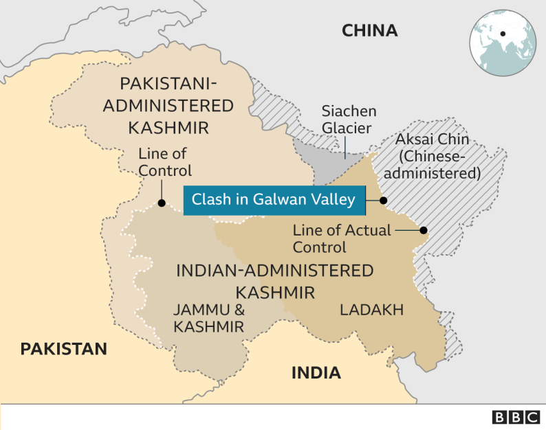
- The 2020 China–India skirmishes are part of an ongoing military standoff between China and India.
- Since 5 May 2020, Chinese and Indian troops have engaged in aggressive face-offs and skirmishes at locations along the Sino-Indian border.
- This includes Pangong Tso Lake in Ladakhand the Tibet Autonomous Region; near the border between Sikkim. Additional clashes also took place at locations in eastern Ladakh along the Line of Actual Control (LAC).
- The 2020 Galwan incidentwas the first military casualty after 1975 at the LAC between India and China. The incident represents a watershed in India’s relations with China and marks the end of a 45-year chapter which saw no armed confrontation involving loss of lives on the Line of Actual Control (LAC).
https://www.thehindu.com/news/national/china-expanding-uav-usage-network-along-border-say-officials/article65329175.ece


