Description
Disclaimer: Copyright infringement not intended.
Context
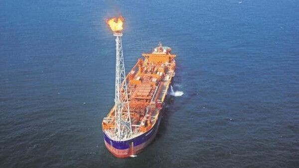
- The state-owned Oil and Natural Gas Corporation (ONGC) has discovered two significant natural gas reserves in the Mahanadi basin block in the Bay of Bengal.
Context Details
- The Maharatna company made the discoveries in the block MN-DWHP-2018/1, which it had won in 2019 in the third round of auction under the open acreage licensing policy
- The development has been made in an area that was earlier classified as a ‘no-go’ area because of national security interests. The first discovery, named Utkal, is in 714 metres of water depth and flowed more than 3 lakh cubic metres per day of gas during initial testing.
Natural gas, a major contributor to India's net zero emission target:
- Significance: Natural gas has been seen as a major tool for India to transition from carbon dioxide-emitting fuels to achieve a net zero carbon emission by 2070. Natural gas has a lower carbon footprint compared to polluting fossil fuels.
- Natural gas is extracted from below ground or sea surface. It is mainly used to generate electricity, make fertilisers, or turn into CNG to use as fuel in automobiles and piped to household kitchens for cooking purposes. Greater use of natural gas will replace coal in power generation and liquid fuels in industries.
- The recent discovery is likely to give an impetus to India's energy security as the country imports nearly half of its gas needs. India is aiming to raise the share of natural gas in its energy basket to 15 percent by 2030 from the current 6.3 percent and more domestic production will aid that.
- Exploration Challenges: The recent development was possible only after the government freed almost one lakh square kilometres of the area from restrictions for exploring and producing oil and gas.
- Earlier, the area was classified as a ‘no-gas’ area because it came in the path of missile testing or on a satellite launch route. However, in 2022 the restrictions on more than 98 percent of the ‘no-go’ areas were removed 2022, allowing for energy companies to send vessels and drillships to find oil and gas.

Mahanadi basin
- The Mahanadi basin is the 8th largest basin in the country having total catchment area of 139681.51 sq. km which is nearly 4.28% of the total geographical area of the country.
- The catchment area of the basin extends over major parts of Chhattisgarh and Odisha and comparatively smaller portions of Jharkhand, Maharashtra and Madhya Pradesh.
- The Mahanadi basin is divided into 3 sub basins, namely upper, middle and lower Mahanadi.
- The upper basin is a saucer shaped and mostly lies in Chhattisgarh state.
- The basin is circular in shape with a diameter of about 400 km and an exit passage of about 160 km length and 60 km breadth.
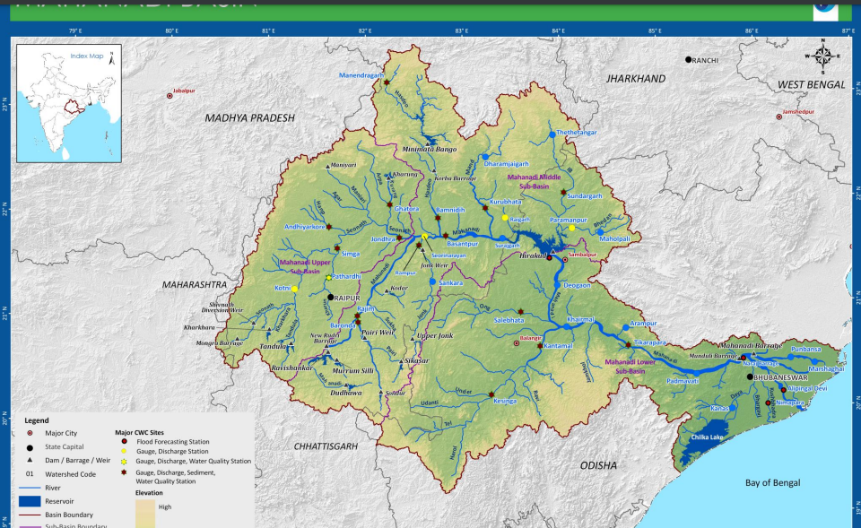
- Physiographical Division: the basin can be divided into four regions, namely, the northern plateau, the Eastern Ghats, the coastal plain and the erosional plains of central table land. The first two are hilly regions. The coastal plain is the delta area which is highly fertile. The central table land is the central interior region of the basin, traversed by the river and its tributaries.
- Climate: The Mahanadi basin experiences four distinct seasons, namely the cold weather, the hot weather, the south-west monsoon and the post monsoon. Koppens classification - Aw
- Rain fall: The basin receives about 90% of its rainfall during the monsoon season. Generally, the southwest monsoon sets by the middle of June over the entire basin and remains active till the end of September. The spatial variation in rainfall is moderate in the basin. The formation of depressions in the Bay of Bengal cause cyclones, which bring about wide spread heavy rains resulting in floods and destructions.
- Natural calamity associated with: The average annual runoff of Mahanadi is 66.9 Billion Cubic Meter. The basin receives uneven rainfall thus drought is prevalent in some districts. Total fourteen districts in the basin are covered under Drought Prone Area programme.
- Districts Jagatsinghpur, Puri and Kendrapara which are situated near coastal parts of Mahanadi face water logging problem.
- Soil :The main soil types found in the basin are red and yellow soils. Mixed red and black soils occur in parts of the Bolangir, Sambalpur, and Sundargarh districts of Orissa. Laterite soil is found in the lower parts of Orissa. The deltaic soil is found in the coastal plains of the Mahanadi. Black soil and sandy soil with "Kankar" are the main soils found in the part of basin lying in Chhattisgarh.
- Agriculture: Except in the Chhatisgarh and coastal plains, the basin has an extensive area under forests. Forest and agriculture are the main stay of the people in the interior parts of the basin. The Chhatisgarh and coastal plains, with a high incidence of rainfall, are predominantly rice growing areas.
- Demography: The coastal plains are the most densely populated while the hilly areas have a relatively low density. The most densely populated districts are Khordha and Jagatsinghpur having population density. Koriya, Kandhamahal and Kanker are few districts with lowest population density in the basin
Mahanadi river
- The Mahanadi river ranks second to the Godavari river among the peninsular rivers in respect of water potential.
- The Mahanadi rises in a pool, 6 km from Pharsiya village near Nagri Town in Raipur district of Chhattisgarh state at an elevation of 457 m. The total length of the river form origin to its outfall into Bay of Bengal is 851 km of which 357 km lies in Chhattisgarh and 494 km in Odisha.
- The river is bounded in the north by Central India hills, in the south and east by the Eastern Ghats and in the west by Maikal hill range.
- The three major tributaries namely Seonath, Ib on the Le Bank and Tel on the Right Bank together constitute nearly 46.63% of the total catchment area of the river Mahanadi.
Tributaries of Mahanadi
- Seonath River: The Seonath River is the longest tributary of Mahanadi. It rises in an undulating region with numerous small groups of hills at Kotgal and flows 383 kilometers to join Mahanadi at its left bank at Khargand.
- Tributaries of Seonath are Kharahara, Tandula, Kharun, Surhi, Agar, Arpa rivers. The total drainage area of Seonath is 22% of the total drainage area of Mahanadi Basin.
- Jonk River: Jonk River originates from the Khariar Hills of Kalahandi district of Odisha at an elevation of 762 meters. It flows 196 kilometers to join the Mahanadi on ints right at Sheorinarayan.
- Hasdo River: It rises in the Sarguja district of Chhattisgarh and traverses 333 kilometers to meet Mahanadi at Mahuadih.
- Gej River is a principle tributary of Hasdo River
- Mand River: Mand River originates at an elevation of 686 meters in Sarguja district of Odisha and flows 241 kilometers to meet Mahanadi at Chandarpur.
- Ib River : Ib originates in Pandrapat of the Raigarh distriuct of Chhattishgarh and flows 251 kilometers to fall into Hirakud Dam. Its a rainfed river.
- Ong River: It rises at an elevation of 457 meters on a hill in the northern outskirts of hills located on the course of Jonk River and flows 204 kilometers to meet Mahandi at Sonepur.
- Tel River: Tel river originates in plain in the Koraput of Odisha. It traverses 296 kilometers to meet Mahanadi at Sonepur.

Conclusion
The literal meaning of Mahanadi River is large size river. The Mahanadi basin drains 141589 Sq. km of area thus ranking 7th in terms of catchment area. It has 4th highest Utilizable surface water potential in India. Blessed with mighty river the Mahanadi, it has given ample opportunity to construct water resources structures across its width.
|
PRACTICE QUESTIONS
Q. Distinguish the nature of Himalayan and peninsular river systems. (150)
|


