Disclaimer: Copyright infringement not intended.
Context
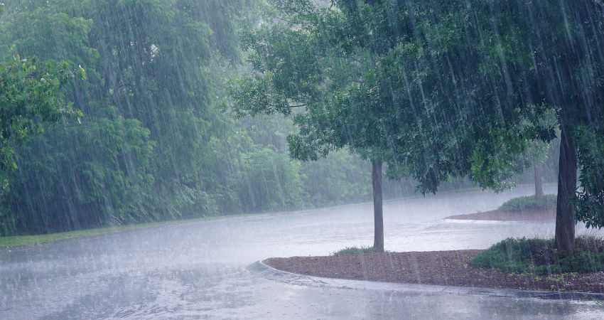
- The southwest monsoon is likely to set in over Kerala on May 27, well ahead of its normal date of June 1, the India Meteorological Department (IMD) announced. The monsoon is slated to make its earliest arrival in 13 years over Kerala.
About Monsoon
- A monsoon (from the Arabic mawsim, which means "season") is a seasonal change in the direction of the prevailing, or strongest, winds of a region.
- Monsoons cause wet and dry seasons throughout much of the tropics.
- Monsoons are most often associated with the Indian Ocean.
- Generally, across the world, the monsoons are experienced in the tropical area roughly between 20° N and 20° S. The climate of India is described as the ‘monsoon’ type. In Asia, this type of climate is found mainly in the south and the southeast.
- Out of a total of 4 seasonal divisions of India, monsoon occupies 2 divisions, namely.
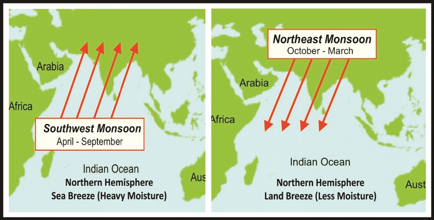
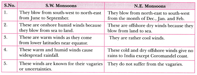
- The southwest monsoon season -Rainfall received from the southwest monsoons is seasonal in character, which occurs between June and September. This is the summer monsoon period where the southwest monsoon holds away over the country. The whole country receives nearly 75% of its rainfall during this period.The Southwest Monsoon winds are called 'Nairutya Maarut' in India.
- The retreating northeast monsoon season -The months of October and November are known for retreating monsoons. In this South West Monsoon starts retrieving from the extreme northwest by the beginning of September, progressively receding southwards.
SOUTHWEST MONSOON SEASON
- Southwest monsoon season is also known as the rainy season in India.
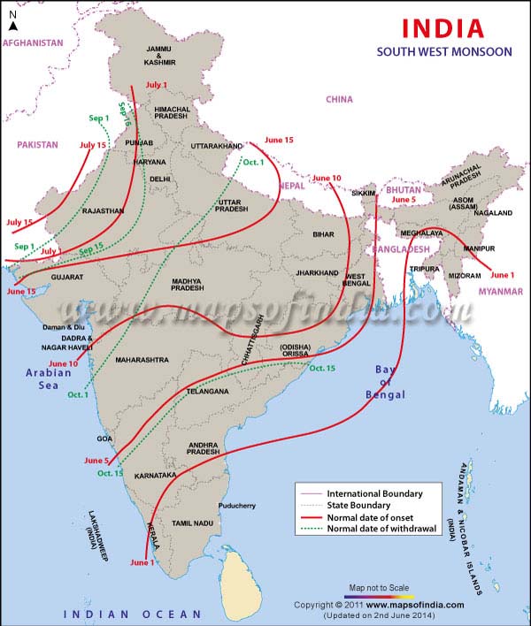
- The onset of Southwest monsoon season takes place over the southern tip of the country’ by the first week of June, advances along the Konkon coast in early June and covers the whole country by 15th July.
- The onset of the monsoon over Kerala marks the beginning of the four-month, June-September southwest monsoon season over India, which brings more than 70 per cent of the country’s annual rainfall.
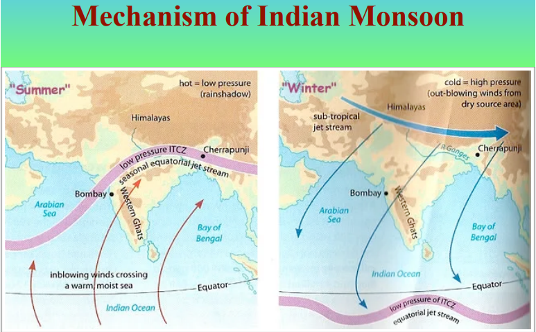
Mechanism : Classical Theory or Thermal Concept of Indian Monsoons:
- According to this theory, the differential heating of land and sea at the time when the sun makes an apparent northward movement is the main cause of the Indian monsoonal regime.
- Two factors are mainly responsible for this very strong development of monsoons:
- Vast size of the Indian subcontinent and adjacent seas;
- Very high and extensive mountain systems of the Himalayas in the north, extending in an east-west direction, thus posing a formidable physical barrier between tropical and polar air masses.
- The second factor is of great meteorological significance. The high mountain chains of the Himalayas which border the subcontinent on three sides work as both a break and motor at the same time. During the winter season, they prevent the penetration of the cold polar air masses from Siberia into the subcontinent, while in summer, the Himalayas do not allow the equatorial maritime air masses to cross the Himalayas and force them to curve round the north-west. The mighty Himalayas produce hydro-dynamic effects that determine the type of precipitation in India.
- According to the thermal concept, during the period following the Spring Equinox (March 23), the sun starts its apparent northward shift. As a result, the areas lying north of the equator (tropics and sub-tropics) - get a progressive high incidence of solar radiation.
- The effect of this phenomenon on the Indian subcontinent is seen in the form of intense heating of the vast northern plains and the adjoining highlands. As a result, a massive low pressure trough is formed extending from the Punjab plains in the north-west to the Bengal delta in the east.
- This low pressure zone attracts wind regimes from the adjoining areas, from short distances in the beginning.
- But as the level of solar incidence reaches its peak during May-June, the pressure gradient between this low pressure trough and the adjoining seas is so great that it attracts winds from as far as the south of the equator.
- Accompanying this process and helping this pull of wind regimes is the development of some high pressure centers—in the Indian Ocean, Arabian Sea and over Australia (it being the winter season in Australia).
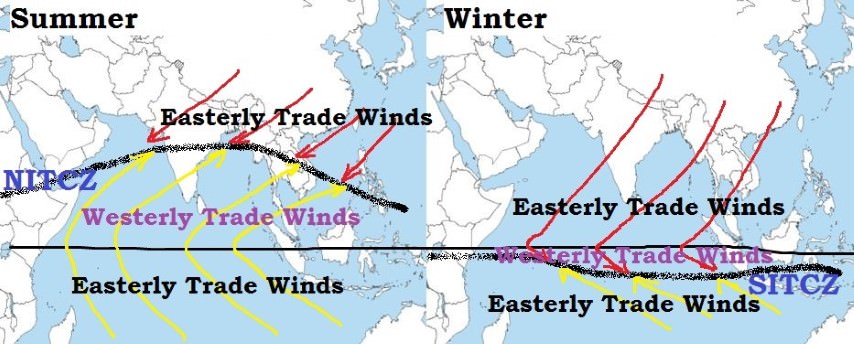
- The wind patterns which are prevalent south of the equator are actually the south-east trade winds which blow from the south-east towards the north-west. These winds, attracted by the low pressure trough over the Indian subcontinent, while moving north of the equator, turn in a clockwise direction (or towards the right), following Farrel’s law. This shift in direction is brought about by the earth’s rotation. Now, the originally south-east trade winds become south-west monsoons blowing towards the north-east.
- At this juncture, the Inter- Tropical Convergence Zone (ITCZ) also shifts northwards. The ITCZ is the hypothetical line where the north-east trade winds from the northern hemisphere and the south-east trades from the southern hemisphere meet. The south-west wands now approaching the Indian peninsula have to travel a long distance over the Indian Ocean.
- During their long journey, these winds pick up large amounts of moisture and by the time they reach India they are oversaturated. Here, they are known as the south-west monsoons which get divided into the Arabian Sea branch and the Bay of Bengal branch because of the shape of peninsular India. There moisture-laden winds cause heavy rainfall on the windward sides.
In a nutshell,
- The reversal of winds start taking place over the Indian sub-continent during the summer season, when cold and dry continental northwesterly winds are replaced by warm and moist southwesterly winds.
- These winds originate in the Southern Hemisphere, cross the Equator (trade winds) and get deflected to the right by the Coriolis force in the Northern Hemisphere. Due to the high temperature over north India creates a low-pressure trough which draws the moisture-laden winds from the Indian Ocean towards the Indian landmass.
- The trade winds then approach the India sub-continent in two separate branches – the Bay of Bengal and the Arabian Sea.
- The sudden approach of monsoon wind over south India with ‘ lightning and the thunder indicates the onset of south-west monsoon. This is also known as “break or burst of monsoon”.
As mentioned earlier the monsoon winds strike against the southern tip of the Indian landmass and get divided into two branches.
(a) Arabian sea branch (of Southwest monsoon)
(b) The Bay of Bengal branch (of Southwest monsoon)
(a) Arabian sea branch of South west monsoon:
- The Arabian sea branch of south west monsoon gives heavy rainfall to the west coast of India as it is located in the wind wards side of the Western Ghats.
- The other part which advances towards north strikes against the Himalayan Mountains results in heavy rainfall in north.
- As Aravalli mountains lie parallel to the wind direction. Rajasthan and the western parts do not get much rainfall.
(b) Bay of Bengal branch of south west monsoon:
- The Wind from Bay of Bengal moves towards north east India and Myanmar.
- This wind is trapped by Garo, Khasi and Jaintia hills and gives the heaviest rainfall to Meghalaya (at Mawsynram).
- This wind gets deflected towards west.
- When the wind moves from east to west rainfall decreases as it loses its moisture.
- Tamil Nadu receives only a meager rainfall as the state is located on the leeward side.
The four-month long Monsoon season, which runs from June to September, brings 70% of the country's annual rainfall. It holds a Long Period Average (LPA) of 89 cm of rain but never behaves in a normal manner. In fact, rainfall distribution mostly remains uneven both in space and time.
Factors Influencing Southwest Monsoon
- The differential heating and cooling of land and water creates a low pressure on the landmass of India while the seas around experience comparatively high pressure.
- The shift of the position of Inter Tropical Convergence Zone (ITCZ) in summer, over the Ganga plain (this is the equatorial trough normally positioned about 5°N of the equator. It is also known as the monsoon-trough during the monsoon season).
- The presence of the high-pressure area, east of Madagascar, approximately at 20°S over the Indian Ocean. The intensity and position of this high-pressure area affect the Indian Monsoon.
- The Tibetan plateau gets intensely heated during summer, which results in strong vertical air currents and the formation of low pressure over the plateau at about 9 km above sea level.
- The movement of the westerly jet stream to the north of the Himalayas and the presence of the tropical easterly jet stream over the Indian peninsula during summer.
- Southern Oscillation (SO): Normally when the tropical eastern south Pacific Ocean experiences high pressure, the tropical eastern Indian Ocean experiences low pressure.
- Jet stream and ELNino are the two factors that determine the occurrence of Southwest monsoon.
Monsoon rely heavily on the role of:
(1) Himalayas and Tibetan plateau as a physical barrier and a source of high-level heat.
(2) Circulation of upper air jet streams in the troposphere.
(3) Existence of upper air circum-polar whirl over north and south poles in the troposphere.
(4) The occurrence of ENSO (El-Nino and Southern Oscillation) in the South Pacific ocean.
(5) Walker cell in Indian Ocean.
(6) Indian Ocean Dipole.
|
Parameters for Monsoon to be declared
IMD announces Monsoon only after certain newly defined and measurable parameters, adopted in 2016, are met.
Rainfall
The IMD declares the onset of the monsoon if at least 60% of 14 designated meteorological stations in Kerala and Lakshadweep record at least 2.5 mm of rain for two consecutive days at any time after May 10. In such a situation, the onset over Kerala is declared on the second day, provided specific wind and temperature criteria are also fulfilled.
The 14 enlisted stations are: Minicoy, Amini, Thiruvananthapuram, Punalur, Kollam, Alappuzha, Kottayam, Kochi, Thrissur, Kozhikode, Thalassery, Kannur, Kasaragod, and Mangaluru.
Wind field
The depth of westerlies should be upto 600 hectopascal (1 hPa is equal to 1 millibar of pressure) in the area bound by the equator to 10ºN latitude, and from longitude 55ºE to 80ºE. The zonal wind speed over the area bound by 5-10ºN latitude and 70-80ºE longitude should be of the order of 15-20 knots (28-37 kph) at 925 hPa.
Heat
According to IMD, the INSAT-derived Outgoing Longwave Radiation (OLR) value (a measure of the energy emitted to space by the Earth’s surface, oceans, and atmosphere) should be below 200 watt per sq m (wm2) in the box confined by 5-10ºN latitude and 70-75ºE latitude.
In general, the Andaman and Nicobar Islands start receiving monsoon rainfall between May 15 and May 20 every year, and it usually starts raining along the Kerala coast in the last week of May. However, the onset is not officially declared until the prescribed conditions (above) are met.
|
Other Features Controlling Monsoon
- The four-month long Monsoon season, which runs from June to September, brings 70% of the country's annual rainfall.
- It holds a Long Period Average (LPA) of 89 cm of rain but never behaves in a normal manner. In fact, rainfall distribution mostly remains uneven both in space and time. It always leaves one guessing and brings anxious moments, anticipatory worries and jitters.
- Monsoon in India is controlled by two important features namely, the Monsoon trough and Monsoon systems.
What are Monsoon Troughs?
- Monsoon trough is basically the meeting place of the Arabian Sea current and the deflected Bay of Bengal current. Wherever these two currents meet, a trough is created and oscillation of this trough brings rain.
- The Monsoon trough is an imaginary line, spread across more than 2000 km, from Sri Ganganagar in Rajasthan to West Bengal. Width-wise the trough is just 100-150 km broad.
RETREATING OR NORTHEAST MONSOON
Classical Thermal Concept
- Towards the end of September, the low pressure centre in the north-west begins to disintegrate and eventually shifts to the equatorial region. The cyclonic conditions are replaced by anti-cyclonic ones. As a result, winds start blowing away from the northern region. Similar anti-cyclonic winds blow from the Tibetan highlands and beyond.
- This is also the time when the sun makes an apparent movement south of the equator. The ITCZ also moves equator wards. Now the winds that dominate the sub-continental landscape are the ones which move from the north-east to the south-west.
- These conditions continue from October till mid-December and are known as the retreating monsoons or the north-east monsoons. By December end, the monsoons have completely withdrawn from India. The retreat of the monsoons is markedly gradual in contrast to the ‘sudden burst’ of the south-west monsoons.
- The retreating monsoons over the Bay of Bengal pick up moisture on their way which is dropped over eastern or coastal Orissa, Tamil Nadu and parts of Karnataka during October-November. This is the main season of rains over these areas as they almost lie in the rain-shadow area of the south-west monsoons.
- The period October to December is referred to as Northeast Monsoon season over peninsular India.
- Northeast Monsoon pertains to five divisions of Southern Peninsula including Coastal Andhra Pradesh, Rayalaseema, South Interior Karnataka, Tamil Nadu as well as Kerala.
- The maximum rainfall is observed in the state of Kerala throughout the season while most amounts of rains are seen in the month of October. Not only this, October happens to be the rainiest month for all the five regions of Peninsular India. November sees slightly lesser rainfall while the least amount of showers are witnessed in the month of December.
- Tamil Nadu, is the biggest beneficiary in terms of rains during this season, as rainfall activity is quite less in the Southwest Monsoon season due to it lying in the rain shadow area. Northeast Monsoon is the first to set in over the state of Tamil Nadu while the last to withdraw from this region.
- Northeast Monsoon sees very high variability both intra and inter-seasonal. The co-efficiency of variation in the season is about 27 percent which means that +/-27 percent of rains during each season is considered to be as normal.
- In fact, the normal range is +/-11 percent which means normal rainfall is between 89 and 111 percent. Huge surplus as well as deficits is also seen during this season.
- In the last few years, there have been varied rain amounts in the Northeast Monsoon season with 2017 witnessing 86 percent of rains, 2016 seeing very little rains at a mere 35 percent, 2015 recorded a whopping 132 percent of rainfall, rains were at 88 percent in 2014, 86 percent in 2013, 93 percent in 2012, 96 percent in 2011 and a massive 154 percent in 2010.
- In contrary to the Southwest Monsoon which sees more rains in La Nina and lesser in El Nino, rainfall activity during the Northeast Monsoon season is higher during the El Nino and very less in La Nina.
Winter Monsoons
- The stable, dry anti-cyclonic winds prevailing over the subcontinent after the retreat of the south-west monsoons are not capable of causing precipitation because they are free of moisture.
- Instead, these winds produce dry and fine weather. However, certain areas in the north get winter precipitation: from sources far away.
- The north-western parts of India—Punjab and Ganga plains—are invaded by shallow cyclonic disturbances moving from west to east and having their origin in the Mediterranean Sea. These are called “Westerly Disturbances’ which travel across West Asia and Afghanistan before they reach India. These disturbances come with cloudiness and rising temperature in the front and cold wind in the rear.
- These disturbances cause upto 5 cm rainfall in Punjab and Kashmir and up to 2.5 cm over the Uttar Pradesh plains. These showers are very good for the rabi crop, especially wheat and gram, and are very effective because of less runoff, less evaporation (because of low winter temperatures) and the fact that moisture from these showers is confined to the root area of the crops.
https://epaper.thehindu.com/Home/ShareArticle?OrgId=GIO9QFTRM.1&imageview=0