Disclaimer: Copyright infringement not intended.
Context
Geospatial Technology
.jpg)
What is Geo-Spatial Data?
Applications of Geospatial Technology
Here are some typical examples of how geospatial technology is applied:
|
Use of Geo-enabled Technology amid Covid-19 The recent Covid-19 pandemic management is a remarkable example where geo-enabled technology was used to develop a health service app, which helped in identifying containment zones, aided in monitoring citizen movement, administrating vaccines and ensuring social distancing. Other geo-enabled technologies helped in managing activities like sanitizing hotspots, establishing telemedicine facilities for remote health care and diagnosis, and analysing infrastructure availability to address the health crisis. |
National Geospatial Policy, 2022
About:
Aim and Objectives:
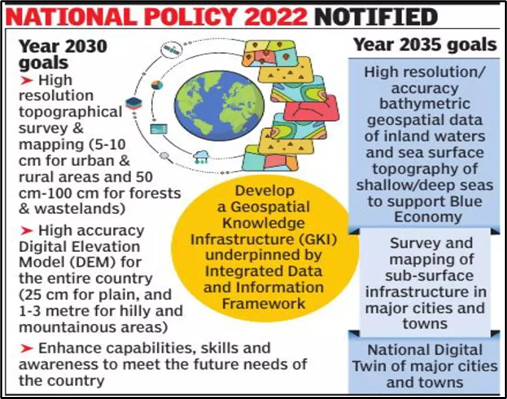
Mandate:
|
GDPDC The GDPDC is a 17-member body to be headed by a person of repute from industry, government or academia, that will drive the overall development of the geospatial ecosystem. It will replace and subsume the functions and powers of National Spatial Data Committee (NSDC) constituted in 2006 and Geospatial Data Promotion and Development Committee constituted in 2021. |
Significance:
Future of Geospatial technologies

Closing Thought
|
DEREGULATION OF THE GEOSPATIAL SECTOR What was the previous policy on Geospatial Data? · There were strict restrictions on the collection, storage, use, sale, and dissemination of Geo-Spatial Data and mapping earlier. · The policy had not been renewed in decades and had been driven by internal as well as external security concerns. · The sector was dominated by the Indian government as well as government-run agencies such as the Survey of India and private companies need to navigate a system of permissions from different departments of the government (depending on the kind of data to be created) as well as the defence and Home Ministries, to be able to collect, create or disseminate geo-spatial data. · GIS mapping was also rudimentary, with the government investing heavily in it after the Kargil war highlighted the dependence on foreign data and the need for indigenous sources of data. · This system of acquiring licenses or permission, and the red tape involved, can take months, delaying projects, especially those that are in mission mode – for both Indian companies as well as government agencies.
The government has deregulated Geo-Spatial Data · The deregulation eliminates the requirement of permissions as well as scrutiny, even for security concerns. · Indian companies now can self-attest, conforming to government guidelines without actually having to be monitored by a government agency- these guidelines therefore place a great deal of trust in Indian entities. · There is also a huge lack of data in the country which impedes planning for infrastructure, development and businesses which are data-based. The mapping of the entire country, that too with high accuracy, by the Indian government alone could take decades. · The government, therefore, felt an urgent need to incentivize the geospatial sector for Indian companies and increased investment from private players in the sector. · There has also been a global push for open access to geospatial as it affects the lives of ordinary citizens, and the new guidelines has ensured such open access, with the exception of sensitive defence or security-related data. |


© 2025 iasgyan. All right reserved