Description
Disclaimer: Copyright infringement not intended.
Context
- Murmansk port the beginning point of the Northern Sea Route (NSR), is witnessing the rising trend of Indian involvement in cargo traffic.
Details
- In the first seven months of 2023, India got the lion’s share with 35% of eight million tonnes of cargo handled by the Murmansk port, which is about 2,000 km northwest of Moscow.
Northern Sea Route (NSR)
- The Northeast Passage [also known as the Northern Sea Route (NSR)], the shortest shipping route for freight transportation between Europe and countries of the Asia-Pacific region, straddles four seas of the Arctic Ocean.
- Running to 5,600 km, the Route begins at the boundary between the Barents and the Kara seas (Kara Strait) and ends in the Bering Strait (Provideniya Bay).
- The Northern Sea Route (NSR) defined by Russian legislation as running from the entrances to the Novaya Zemlya straits in the west, along the Russian Arctic coast above Siberia through the Kara Sea, Laptev Sea, East Siberian Sea, and Chukchi Sea, to Cape Zhelaniya on the Bering Strait.
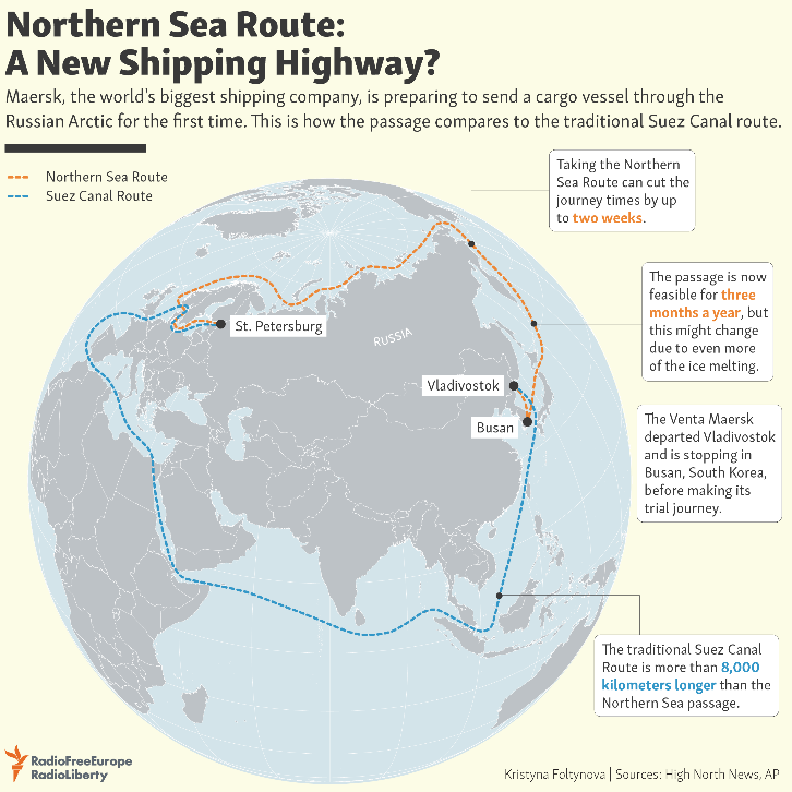
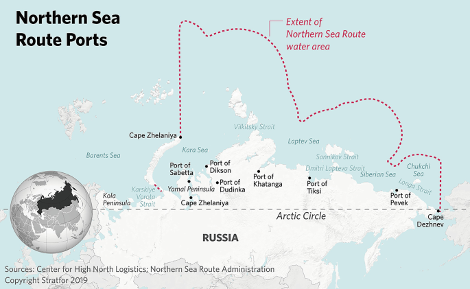
- The entire route lies in Arctic waters and within Russia's exclusive economic zone (EEZ), and is included in what has been called the Northeast Passage, analogous to Canada's Northwest Passage.
- The Northern Sea Route itself does not include the Barents Sea, and it therefore does not reach the Atlantic.
- The Northern Sea Route currently serves the Arctic ports and major rivers of Siberia by importing fuel, equipment, food and exporting timber and minerals.
- Some parts of the route are only free of ice for two months per year, but melting Arctic ice caps are likely to increase traffic and the commercial viability of the Northern Sea Route.
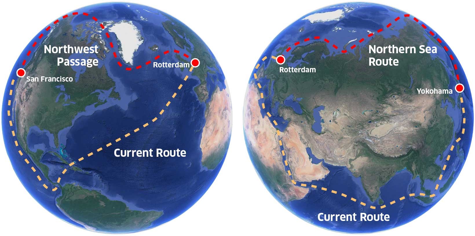
- Distance savings along the NSR can be as high as 50% compared to the currently used shipping lanes via Suez or Panama.
- The 2021 blockage of the Suez Canal, which forms part of the widely-used maritime route involving Europe and Asia, has led to greater attention on the NSR.
Northern Sea Route Vs North west passage
- The Northwest Passage is a series of possible shipping routes connecting the Atlantic and Pacific Oceans through the Canadian Arctic.
- The Northeast Passage (also known as the Northern Sea Route) is any shipping route between Europe and Asia along the northern shores of Russia.
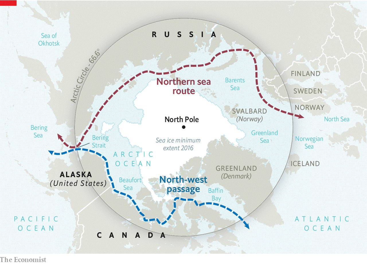
Who owns the Northwest and Northeast Passages?
- International law states that no one owns the North Pole, or the oceans immediately surrounding it. The five ‘Arctic nations’ (US, Russia, Canada, Norway, and Greenland) adjacent to the Arctic Ocean can each claim as an exclusive economic zone (EEZ) the 200 nautical miles of ocean off their coastline. However, there is much dispute over whether other parts of the seas in this region form a country’s national waters or internal waters.
- In 1985, Canada designated the whole area through which the Northwest Passage passes as a Canadian archipelago (group of islands), claiming the route as part of their internal waters.
- If this was deemed to be the case, Canada would be able to regulate fishing and set laws on smuggling, shipping, and the environment, however, it would not be able to close the route to navigation by foreign vessels.
- Canada has until 2013 to submit its case officially to the UN. Until then, the uncertainty over sovereignty of the Northwest Passage continues. For example, the US disputes the Canadian’s claim and considers that the Passage is an international strait.
Why are they so important?
- The main reason that the Northwest and Northeast Passages are so important is for shipping.
- The Northwest Passage route is 7,000 km shorter than the current route through the Panama Canal, and the Northeast Passage route is one-third of the distance of the traditional route through the Suez Canal.
- Shorter distances mean less travel time, lower fuel consumption and costs.
- The Managing Director of one shipping company, Nordic Bulk Carriers, has estimated that using the Northeast Passage instead of the Suez Canal would save up to $180,000 in fuel costs. There is also the much-reduced level of piracy through these northern routes, compared to the risk of piracy for ships in the Indian Ocean that are using the Suez Canal.
Why aren’t they used all the time, then?
- The Arctic shipping routes aren’t used all the time because this region is frozen over for most of the year. However, although in the far north, the sea ice is permanent; at lower latitudes it is seasonal.
- Climate change is gradually increasing the area that is ice-free during the summer, and lengthening the period that it remains so. A representative of the organization Environment Canada notes that the temperature in the Canadian Arctic has risen by 1.2°C in the last century, which is twice the global average. Ice cover in this region has been reduced by 32% since the 1960s. As a result of global warming, the Northwest and Northeast Passages are becoming increasingly viable as shipping routes.

How is Russia making the NSR navigable?
- As the seas of the Arctic Ocean remain icebound during most of the year, icebreaking assistance is organized to ensure safe navigation along the NSR.
- Russia is the only country in the world with a nuclear-powered icebreaker fleet.
- In December 1959, the world’s first nuclear icebreaker, “Lenin,” was put into operation, unveiling a new chapter in the NSR development. It was decommissioned 30 years later.
- Today, FSUE Atomflot, a subsidiary of Rosatom, acts as the fleet operator of nuclear-powered icebreakers. The fleet comprises seven nuclear-powered icebreakers, apart from one nuclear container ship. Three more are expected to be commissioned between 2024 and 2027.
Why is the Arctic region significant to India?
- India has been showing greater interest in the NSR for a variety of reasons.
- The vulnerability of the Arctic region, which is above the Arctic Circle and includes the Arctic Ocean with the North Pole at its center, to unprecedented changes in the climate may have an impact on India in terms of economic security, water security, and sustainability.
- The region also constitutes the largest unexplored prospective area for hydrocarbons remaining on the earth.
- It is estimated that the region may hold over 40 percent of the current global reserves of oil and gas.
- There may also be significant reserves of coal, zinc and silver.” However, the government’s Arctic Policy of 2022 mentions that the country’s approach to economic development of the region is guided by UN Sustainable Development Goals.
|
In 2009, the US Geological Survey carried out a scientific study that found that 25% of the world’s untapped oil and gas reserves are located in the Arctic region. The area is also rich in other natural resources, including nickel, iron ore, phosphate, copper, cobalt, uranium, and gold. In the past it has been difficult to explore the natural resources of the region, and impossible to exploit them, due to the ice cover. However, climate change may be making this more possible.
One of the main global markets for energy and natural resources is China. The extension of the ice-free period in the Arctic has two benefits: the exploitation of natural resources, and the opportunity for companies to transport them to China via the Northwest and Northeast Passages.
It is for this reason that ownership of the shipping routes has become a contentious issue in recent years.
Another industry to benefit from ice-free summers in the Arctic is tourism. More and more Arctic cruises are being offered the chance to see wildlife, watch the Aurora Borealis (northern lights), and sail through icy seas. Tourism is having a positive economic effect on countries such as Greenland, bringing income and jobs.
|
How old is India’s engagement with the Arctic?
- India’s engagement with the Arctic can be traced to the signing of the Svalbard Treaty in February 1920 in Paris.
- India is undertaking several scientific studies and research in the Arctic region. This encompasses atmospheric, biological, marine, hydrological and glaciological studies.
- Apart from setting up a research station, Himadri, at Ny-Ålesund, Svalbard, in 2008, the country launched its inaugural multi-sensor moored observatory and northernmost atmospheric laboratory in 2014 and 2016 respectively.
- Till last year, thirteen expeditions to the Arctic were successfully conducted.
- In May 2013, India became an observer-state of the Arctic Council along with five others including China.
What are the driving factors for India to participate in the NSR development?
- Primarily, the growth in cargo traffic along the NSR is on the constant rise and during 2018-2022, the growth rate was around 73%. Last year, the volume of cargo traffic was 34.117 million tonnes.
- With India increasingly importing crude oil and coal from Russia in recent years, “the record supplies of energy resources for the Indian economy are possible due to such a reliable and safe transport artery as the NSR.”
- Secondly, the NSR, as a transit route, assumes importance, given India’s geographical position and the major share of its trade associated with sea transportation.
- Thirdly, the Chennai-Vladivostok Maritime Corridor (CVMC) project, an outcome of signing of the memorandum of intent between the two countries in September 2019, is being examined as one linking with another organise international container transit through the NSR.
- The 10,500 km-long CVMC, passing through the Sea of Japan, the South China Sea and Malacca Strait, will bring down transport time to 12 days, almost a third of what is taken under the existing St. Petersburg-Mumbai route of 16,000 km.
- Coking coal [used by steel companies], crude oil, Liquified Natural Gas (LNG) and fertilisers are some of the cargo that can be imported from Russia to India through CVMC.
- Fourthly, experts are discussing the possibility of China and Russia gaining collective influence over the NSR.
What lies forward?
- The NSR development plan until 2035, as approved by the Russian government last year, sets the cargo traffic target as 80 million tonnes and 150 million tonnes for 2024 and 2030. The plan approval took place amid economic sanctions imposed by the West against Russia.
- In March 2023, a Russian delegation held meetings with the Indian business community on the NSR development. The delegation had promised to provide the availability of key components for the year-round operation of the route.
- Russia seeks the participation of Indian companies in projects related to the NSR.
- As for the CVMC project, a workshop, featuring stakeholders from the two countries, is expected to be held in the second half of October.
What is the impact of all this on the environment of the Arctic?
- Many environmental groups oppose any future exploitation of the Arctic region. In addition, an increase in the numbers of cargo ships cargo ships using the Arctic Sea routes may have a very specific impact on climate change. These ships use advanced diesel engines which emit black carbon (soot) into the atmosphere.
- Black carbon acts as a greenhouse gas in a similar way to carbon dioxide, and in addition, when it is deposited on snow and ice it alters the albedo (the reflective quality) of these surfaces.
- White surfaces such as snow and ice reflect sunlight, keeping the ground relatively cool. In contrast, black surfaces (such as when the snow is covered by soot) can absorb more energy from the sunlight leading to relatively higher ground temperatures and the potential for the snow and ice to melt.
- An Increased number of ships travelling through the Arctic may also bring new species into this distinct ecosystem. For example, species ‘alien’ to the Arctic may be carried in water used by ships for ballast or on their hulls.
- These ships may also threaten the biodiversity of the Arctic’s ballast. Introducing aggressive new species to the region in this way could have a serious impact on Arctic ecosystems.
- Opening up the Arctic Ocean would also create the potential for more fishing, which may need international action to establish quotas on the levels and species of fish caught.

Closing Remarks
- The Northwest and Northeast Passages have up until now been used relatively infrequently, and as a result, not all of the potential routes have been fully mapped or surveyed.
- Given the potential for sea ice, thick fog region.
- Marine creatures can attach to the bottom of ships and be transported across the globe, or they may be carried in water used and extreme cold this area still presents a significant challenge for shipping.
- And if a ship were to get into trouble there are few search and rescue services available.
- The melting of ice in the Arctic region, as a result of climate change, may also affect the livelihoods of indigenous peoples and their ability to hunt for food such as seals and walruses.
- However, the increased presence of oil companies provides jobs, infrastructure and services for members of these communities.
- In addition, these companies also often provide wider support for the local communities, such as investment in schools, leisure and other community facilities.
|
PRACTICE QUESTION
Q. Shed light on the importance of Northwest and Northeast Passages. What are the driving factors for India to participate in the Northern Sea Route Development and why is the Arctic region significant to India?
|
https://www.thehindu.com/news/international/explained-india-and-the-northern-sea-route/article67230900.ece


