Description
Disclaimer: Copyright infringement not intended.
Context
- India and Sri Lanka on Saturday launched a ferry service across the Palk Strait under a new roadmap for greater connectivity, nearly four decades after the link between Nagapattinam in Tamil Nadu and Kankesanthurai in Jaffna was disrupted by the civil war in the island nation.
- The ferry service is expected to boost travel and trade with Kankesanthurai, the Sri Lankan port located closest to ports on India’s west coast.
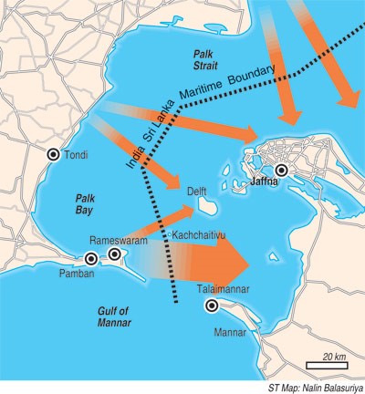
About Palk Strait
- It is a strait that connects India's Tamil Nadu state to the island nation of Sri Lanka.
- The strait is named after Robert Palk, a British Raj administrator of the Madras Presidency (1755-1763).
- Pamban Island (India), Adam's (Rama's) Bridge (a chain of shoals), the Gulf of Mannar, and Mannar Island (Sri Lanka) border it on the south.
- It connects the northeastern Bay of Bengal to the southwesterly Gulf of Mannar.
- Palk Bay is another name for the strait's southwestern section.
- The strait stretches for 40 to 85 miles (64 to 137 kilometers), is 85 miles long, and is less than 330 feet (100 metres) deep.
- Several rivers flow into it, including the Vaigai River of Tamil Nadu.
- The port of Jaffna, the commercial centre for northern Sri Lanka, lies on the strait.

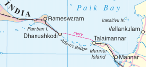
Facts regarding Adam's Bridge
- Adam's Bridge is a line of limestone shoals that connects Pamban Island, also known as Rameswaram Island, off the south-eastern coast of Tamil Nadu, India, and Mannar Island, off the northwestern coast of Sri Lanka.
- According to geological data, this bridge was formerly a land route between India and Sri Lanka.
- The 50-kilometer-long bridge connects the Gulf of Mannar (southwest) to the Palk Strait (northeast).
- Some of the sandbanks are dry, and the sea in the area is very shallow, barely 1 to 10 meters deep in spots, making navigation difficult.
- Scientists believe Ram Setu is a natural structure formed due to tectonic movements and sand getting trapped in corals.
- The structure has significance in both Hindu and Muslim mythology.
- While the Hindus believe this is the bridge built by Lord Ram and his army to cross to Lanka and fight Ravan, as per Islamic legend, Adam used this bridge to reach Adam’s Peak in Sri Lanka, where he stood on one foot for 1,000 years in repentance.
The back story around Palk Strait
- Fishermen of India and Sri Lanka have been unable to agree on how to share the fish in the narrow Palk Strait separating the two countries.
- The strait is known to be a breeding ground for rich marine resources, especially shrimp.
- Although India and Sri Lanka agreed to divide the strait with an imaginary boundary line in the 1970s the International Maritime Boundary Line (IMBL) – Indian fishermen, from the coastal districts of Tamil Nadu, and Puducherry, are frequently arrested by the Sri Lanka Navy for “poaching” or engaging in “illegal” fishing activity in Sri Lanka waters.
- Several rounds of bilateral negotiations between the two governments and talks between fishing community leaders from both sides have been held over the years, but a solution remains elusive.
|
PRACTICE QUESTION
Which one of the following is the correct sequence of the positions in the Bay of Bengal from North to South?
A) Gulf of Mannar-Palk Strait – Palk Bay
B) Palk Strait- Gulf of Mannar- Palk Bay
C) Palk Strait- Palk Bay- Gulf of Mannar
D) Palk Bay- Palk Strait- Gulf of Mannar
Answer: C
|