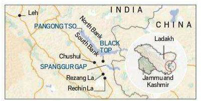
The 15th round of Corps Commander talks between India and China began on the Indian side of Chushul Moldo Meeting Point in eastern Ladakh.
The immediate focus is on working out a disengagement agreement at Patrolling Point 15 in the Gogra-Hot Springs area as part of the overall disengagement and de-escalation process.
Pangong Tso
Pangong Tso is an endorheic saline lakespanning eastern Ladakh and West Tibet.
It has a land-locked basinseparated from the Indus River basin by a small elevated ridge.
It is 134 km long and divided into five sublakes, called Pangong Tso, Tso Nyak, Rum Tso (twin lakes) and Nyak Tso.
The lake, a glacial melt, has mountain spurs of the Chang Chenmo range jutting down, referred to as fingers.
Pangong Tso is in disputed territory. The Line of Actual Control passes through the lake.
Approximately 50% of the length of the overall lake lies within Tibet China,40% in Ladakh India and the rest is disputed and is a de-facto buffer zone between India and China.
An Inner Line Permit is required to visit the lake as it lies on the Sino-Indian Line of Actual Control.
PP15 and 17A
Along the Line of Actual Control (LAC) between India in China, Indian Army has been given certain locations that its troops have to access to patrol the area under its control.
These points are known as patrolling points, or PPs, and are decided by the China Study Group (CSG).
CSG was set-up in 1976, when Indira Gandhi was the prime minister, and is the apex decision-making body on China.
Barring certain areas, like Depsang Plains, these patrolling points are on the LAC, and troops access these points to assert their control over the territory.
It is an important exercise since the boundary between India and China is not yet officially demarcated.
PP15 and PP17A are two of the 65 patrolling points in Ladakh along the LAC.
PP15 is located in an area known as the Hot Springs, while PP17A is near an area called the Gogra post.
Both of these are close to the Chang Chenmo river in the Galwan sub-sector of the LAC in eastern Ladakh.
While Hot Springs is just north of the Chang Chenmo river, Gogra Post is east of the point where the river takes a hairpin bend coming southeast from Galwan Valley and turning southwest.
The area lies close to Kongka Pass, one of the main passes, which, according to China marks the boundary between India and China.
Hot Springs and Gogra Post are close to the boundary between two of the most historically disturbed provinces of China.