Disclaimer: Copyright infringement not intended.
Context
- The tribals in Gujarat will hold a public meeting today to protest against the Centre’s Par Tapi Narmada river-linking project.
Par Tapi Narmada river-linking project
Genesis
- The Par Tapi Narmada link project was envisioned under the 1980 National Perspective Plan under the former Union Ministry of Irrigation and the Central Water Commission (CWC).
Proposal
- The project proposes to transfer river water from the surplus regions of the Western Ghats to the deficit regions of Saurashtra and Kutch.
- It proposes to link three rivers —
- Par, originating from Nashik in Maharashtra and flowing through Valsad,
- Tapi originating from Saputara that flows through Maharashtra and Surat in Gujarat,
- Narmada originating in Madhya Pradesh and flowing through Maharashtra and Bharuch and Narmada districts in Gujarat.
Objective
- The project aims to harness the excess water that flows into the sea by interlinking the rivers.
- This will also help in containing regular flood-like situations in the rivers in Valsad, Navsari, Surat and Bharuch.
Dams to be constructed
- The link mainly includes the construction of seven dams - Jheri, Mohankavchali, Paikhed, Chasmandva, Chikkar, Dabdar and Kelwan.
- Of these, the Jheri dam falls in Nashik, while the remaining dams are in Valsad and Dang districts of South Gujarat.
Water usage and Irrigation benefits
- The surplus water proposed to be diverted through the estimated Rs 10,211 crore Par-Tapi-Narmada link project is expected to irrigate an area of 2,32,175 hectares.
- The excess water in the interlinked Par, Tapi and Narmada rivers which flow into the sea in the monsoon would be diverted to Saurashtra and Kutch for irrigation.
- During the monsoon season, the water which is supplied to Saurashtra through the state government from Sardar Sarovar dam will be saved and used for other purposes.
- Presently the water of Sardar Sarovar is used in urban areas and for irrigation in Saurashtra.
How will the project affect villages?
- According to a report by the NWDA, about 6065 ha of land area will be submerged due to the proposed reservoirs.
- A total of 61 villages will be affected, of which one will be fully submerged and the remaining 60 partly. The total number of affected families would be 2,509 due to the creation of the Jheri reservoir, Kelwan reservoir, Dabdar reservoir, Chikkar reservoir and Paikhed reservoir.
- The affected villages are located in Nashik, Valsad, Vansda and Ahwa in Gujarat.
- The affected families may lose their lands or houses or both in the submergence when the reservoirs are created, says the NWDA report.
- As per the report, the affected families would be compensated for the loss of their lands and houses and those whose houses are submerged, would be resettled.
River-linking project
- The Indian Rivers Inter-link aims to link India’s rivers by a network of reservoirs and canals and so reduce persistent floods in some parts and water shortages in other parts of India.
- The Inter-link project has been split into three parts: a northern Himalayan rivers inter-link component, a southern Penisular Rivers.
- The project is being managed by India’s National Water Development Agency (NWDA), under its Ministry of Water Resources.
- The idea to link rivers emerged with the establishment of the National Water Development Agency in 1982 by then prime minister Indira Gandhi.
Component of National River Planning project
- Himalayan Component
- Peninsular Component
The Basic idea is to connect the Himalayan and peninsular rivers via a network of canals so that excess water from one channel can be diverted to another which has inadequate flow.
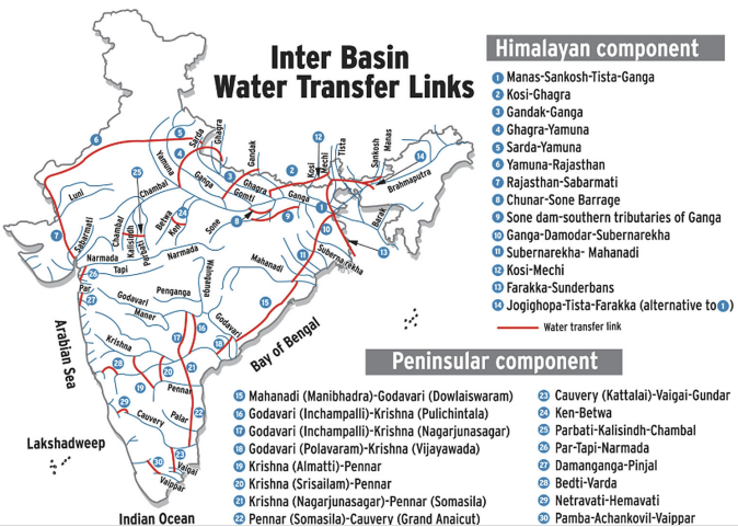
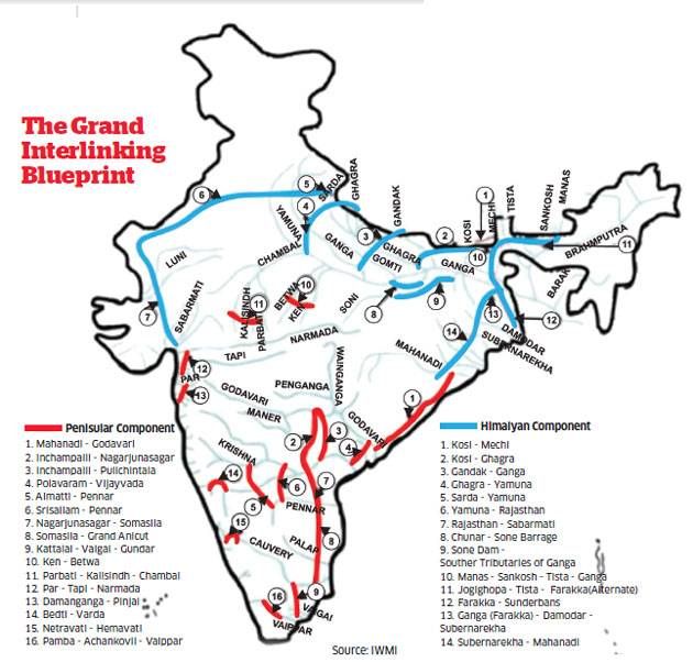
Himalayan River Component
- As shown in the above figure, fourteen link canals are proposed under this component.
- It envisages construction of storages on the main Ganga and the Brahmaputra rivers and their principal tributaries in India and Nepal so as to conserve monsoon flows for flood control, hydropower generation and irrigation.
- Inter-linking canal systems will be provided to transfer surplus flows of the Kosi, Gandak and Ghagra to the west.
- In addition, Brahmaputra-Ganga Link will be constructed for augmenting dry weather flows of the Ganga.
- Surplus flows available on account of inter-linking of Ganga and Yamuna are proposed to be transferred to the drought areas of Haryana, Rajasthan and Gujarat.
- The scheme will benefit not only parts of India but also our neighbours – Nepal and Bangladesh.
- Planning and implementation of this scheme will have to include Nepal, Bhutan and Bangladesh as they also are part of the same hydrological unit.
Peninsular River Component
- Sixteen link canals are proposed under this component as illustrated in the map.
- Amongst the Peninsular rivers, the Mahanadi and Godavari have sizeable surpluses after meeting the existing and projected needs of the state within these basins.
- It is, therefore, proposed to provide terminal storages on Mahanadi and Godavari rivers to divert surplus flows of Mahanadi to the Godavari system and to further transfer surplus from the Godavari Systems to water short rivers namely, Krishna, Pennar and Cauvery.
- The link from Mahanadi to Godavari will be along the east coast and will not involve any lift.
- The link between Godavari and Krishna will be partly by gravity and partly by lift of the order of 120 m maximum.
- The transfer of waters by successive exchange would enable irrigation in drought areas of Maharashtra, Karnataka, Andhra Pradesh and Tamil Nadu.
- It also envisages interlinking of west flowing rivers, benefiting states like Tamil Nadu, Karnataka, Gujarat, M.P. and Rajasthan.
MERITS OF INTERLINKING
Food Security
- The projected population of India is expected to stabilize at about 1600 million by the year 2050 from the present population of about 1100 million.
- The food requirement for this increased population will rise from 260 million tons at present to 460 million tons in 2050.
- The proposed river link is going to increase irrigated area from the present 113 million hectare to 156 million hectare by 2050 ensuring our food security.
Hydropower Development
- At present, the share of hydropower is only about 25% of the total power generation since our hydro-power development is only about 28,000 MW out of the potential of about 84,000 MW.
- Only 2% of the potential of north-east has been developed so far, although 45% of total hydro-power potential of the country lies there.
- The proposed grid, especially the Himalayan component, is going to provide 34,000 MW of additional hydropower for peaking purpose and for increasing the desired share of hydro to about 40%
Water Supply for Drinking and Industry
- The proposed NPP envisages supply of clean drinking water and water for industrial use amounting to 90 and 64.8 billion cum. respectively with a view to meet the demand by 2050.
- This will remove the current hardship, especially for the rural women who have to walk long distances daily to collect water for drinking and other domestic uses. No industrial growth is feasible without guaranteed water supply.
Navigation for inland water transport
- Currently, the national waterways run only for about 120 days or so in a year due to inadequate depth in the rivers, which is less than the required minimum depth of about 2m.
- The proposed grid is going to ease pressure on railways and roads by introducing inland navigation – through National Waterways ( I, II, & III) by guaranteeing a minimum 2 m depth of water on all the 365 days in a year.
Flood and Drought Protection
- While one part of the country is devastated by recurring floods, the other part is suffering from drought due to acute shortage of water. The main challenge is how can the water causing devastation and running waste into the sea (especially from Brahmaputra, Ganga and Mahanadi Basins) can be diverted for productive use in the drought prone areas in the South and the West, so that the country gets rid of the current flood-drought-flood syndrome. The answer lies in river linking.
Increased Employment Opportunities in Rural Areas
- People in the rural areas are now compelled to migrate to cities in search of jobs, causing rapid deterioration of our national economy. Villages are getting poorer and cities are getting congested – resulting in unprecedented pollution of air, water and soil in the cities.
- Only way to reverse this unhealthy trend is to create more job opportunities in rural areas through agricultural and agro-industry based projects.
- As the proposed link canals and the storages are going to be mostly in rural areas, it is going to create large employment opportunities for the rural youths.
Dry Weather Flow Augmentation
- Transfer of surplus water stored in reservoirs during monsoon and releasing it during dry season will ensure a minimum amount of dry weather flow in the rivers which will help in pollution control, navigation, fisheries, growth of forests, protection of wild life etc.
- Any water body either in storage reservoirs or in flowing link canals will be very attractive and offer recreational opportunities for both rural and urban people.
In a nutshell Inter State River Linking will,
- Create the potential to increase agricultural production by an additional 100 per cent over the next five years;
- Avoid the losses of the type that occurred in 2002 to the extent of $550 million by the loss of crops because of extreme draught or flood condition;
- Unify the country by involving every Panchayat as a share holder and implement agency;
- Provide for enhancing the security of the country by an additional waterline of defense;
- Provide employment to the 10 lakh people for the next 10 years;
- Eradicate the flooding problems which recur in the northeast and the north every year;
- Solve the water crisis situation by providing alternative, perennial water resources;
- The large canals linking the rivers are also expected to facilitate inland navigation too;
- Increasing food production from about 200m tones a year to 500m;
- Boost the annual average income of farmers, from the present $40 per acre of land to over $500.
DEMERITS AND CHALLENGES OF INTERLINKING
- Although NPP has several merits as mentioned above, it has several demerits too as pointed out by the opposing group. These are briefly discussed underneath.
Environmental Problems
- A group of people, especially the NGOs, the Socio-Economic and the environmental lobby are strongly against the inter-link.
- They apprehend that such a massive inter- basin transfer of water will eventually result in environmental degradation, climatic changes, evaporation losses , loss of aquatic eco-system, water logging and salinity and submergence of vast areas of land in reservoirs and the huge network of unlined open canals
- For example, the approved Ken — Betwa river link in the Madhya Pradesh — Uttar Pradesh region will submerge 5000 hectares of Penna Tiger reserve.
- Also, in south India, an environmental impact study by the Center for Water Resources and Distribution Management (CWRDM) claims that the proposed Pampa-Achankovil-Vaipar link could potentially create an ecological disaster for both the Vembanad wetland system and the biodiversity of the Western Ghats.
Loss of Livelihood & Displacement of Tribal Poor People
- The project will cause loss of land, forests, fisheries etc. on which most of the poor and tribal people sustain their livelihood.
- There will be massive displacement of people losing their age old property, source of income, their culture and identity.
Massive Investment Required for Implementation
- The estimated cost for the implementation of the project at 2000 price index is Rs.5.6 lakh crores, which is likely to further increase manifold due to cost and time overrun.
- Such a massive investment in water sector is going to deprive important projects in other sectors for our socio-economic development due to inadequacy of funds.
Interstate Dispute
- In almost all the projects executed in the country so far, water of a river basin has been shared only by the riparian states.
- The proposed scheme envisages transfer of water from surplus basins to drought prone basins irrespective of whether they are riparian/cobasin or not.
- Recently, the country has witnessed bitter quarrel and animosity amongst the states of Karnataka and Tamil Nadu over the sharing of water from rivers Cauveri and Krishna, even though both the states are riparian states.
- One can well imagine the degree of complexity and the dispute that will arise over sharing of water from the proposed scheme where a large numbers of states are involved, resulting in tension and rivalry amongst the people of different states. Who is going to control, operate and maintain this mega project remains a questions.
Inter-country relations
- Changing the Himalayan water system in the north east will affect the regions of Bangladesh, Myanmar, Nepal and Bhutan.
- For example, in the year 2000 the state Arunachal Pradesh suffered flash floods due to a breach in the dam constructed on the river Tsangpo (called as Brahmaputra in India)in Tibet.
- Who will bear these costs remains a question. There is a need that other countries be made partners in the construction of such large scale projects.
In a nutshell, major disadvantages of ILR are
- Environmental costs (deforestation, soil- erosion, etc.)
- Rehabilitation: not an easy task
- Social unrest/Psychological damage due to forced resettlement of local people (for example, Sardar Sarovar Project)
- Political effects: strained relationship with neighbors (Pakistan, Bangladesh).
Alternatives of Inter State River Linking
- Water harvesting at a national scale to rejuvenate the depleting water table levels.
- Improving existing irrigation systems.
- One of the alternatives to NRLP that has been discussed is virtual water trade within the country. Proponents of this alternative have argued that instead of physically transferring large quantities of water from the flood-prone east to the water scarce west and south, it would be desirable to transfer virtual water in the form of food grains.
- Setting up desalination plants.
- Control of river pollution.
In many places across India, such initiatives have shown their positive potential while larger scale projects have failed miserably. Best example is Maharashtra, which has the country’s largest concentration of large dams and the least irrigation potential.
Final Thoughts
- The immediate need is to examine the feasibility of the river links and other alternatives to interlinks with more data and sound economic analysis of cost- benefit of different alternatives to achieve the same objectives.
- A master plan should be prepared adopting a strategy of implementing the different components of the master plan (including river-linking) in a phased manner so that the immediate problems of the donor states are given the topmost priority for their economic upliftment.
- The first phase of the execution should be to develop water resources management within the river basin and then to interlink the rivers to facilitate transfer of water from surplus areas to deficit areas.
https://indianexpress.com/article/explained/par-tapi-narmada-river-linking-project-protests-explained-7826710/


