Description

Disclaimer: Copyright infringement not intended.
Context: Scientists from the ISRO have successfully mapped the submerged structure of Adam's Bridge.
Details
|
Other names
|
|
|
Historical naming
|
- Ibn Khordadbeh's Kitāb al-Masālik wa-l-Mamālik referred to it as "Set Bandhai" or "Bridge of the Sea."
- Al-Biruni's Tārīkh al-Hind (c. 1030) introduced the name "Adam's Bridge,".
|
|
Location
|
- Between Pamban Island, off the south-eastern coast of Tamil Nadu and Mannar Island, off the north-western coast of Sri Lanka.
- Separates the Gulf of Mannar (southwest) from the Palk Strait (northeast)
|
|
Length
|
|
|
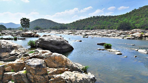
Structure
|
- Some of the sandbanks are dry and the sea in the area is very shallow, being only 1 to 10 metres deep in places.
- According to temple records it was completely above sea level until it broke in a cyclone in 1480.
|
|
Geological evolution
|
- Limestone shoals.
- Series of parallel ledges of sandstone and conglomerates.
- Indian Space Research Organization (ISRO) concludes that Adam's Bridge comprises 103 small patch reefs lying in a linear pattern with reef crest, sand cays and intermittent deep channels.
Cays, also known as keys, refer to low-elevation islands situated on surfaces made of coral reef.
|
|
Transport Corridor
|
- In 2005, the government of India approved Sethusamudram Shipping Canal Project.
- Aims to create a ship channel across the Palk Strait by dredging the shallow ocean floor near Dhanush Kodi.
- Underwater exploration project earlier done through vessel named Sindhu Sadhana.
Sindhu Sadhana is an indigenous exploration vessel which can stay underwater for up to 45 days.
|
|
Biosphere reserves
|
- The coral reef platforms between Thoothukudi and Rameswaram in the Gulf of Mannar were notified as a marine biosphere reserve in 1989.
|
|
Religious significance
|
- Hindu believers hold it as the structure that Lord Rama and his army built to reach Lanka.
- Muslim tradition holds that Adam's Bridge was crossed by Adam following his expulsion from the Garden of Eden.
|
|
Recent Mapping and Findings
|
- Map reveals the bridge's continuity from Dhanushkodi to Talaimannar, with a staggering 99.98 per cent of it submerged in shallow waters.
- Discovered 11 narrow channels that allowed water to flow between the Gulf of Mannar and Palk Strait, playing a crucial role in preserving the structure from sea waves.
Technology Used
- The researchers used NASA's ICESat-2 data from October 2018 to October 2023 to generate a 10-meter resolution map of the full length of the submerged ridge.
|
Sources:
Republic,Wikipedia.
|
PRACTICE QUESTION
Q. The Ram Setu carries the unique geological imprints of an eventful past and needs to be preserved. Justify. 150 words.
|