Description
Disclaimer: Copyright infringement not intended.
Context
- We are “not averse” to demilitarisation of the Siachen glacier but the pre-condition is Pakistan has to accept the Army chief General Manoj Naravane said.
About
Location
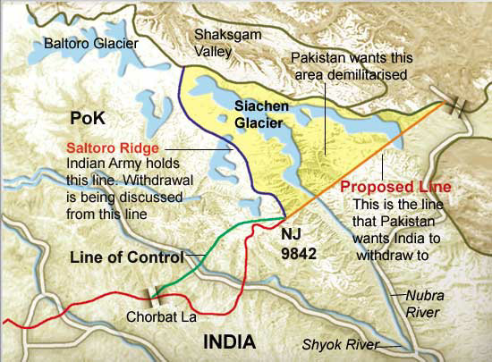
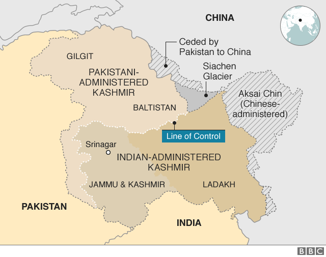
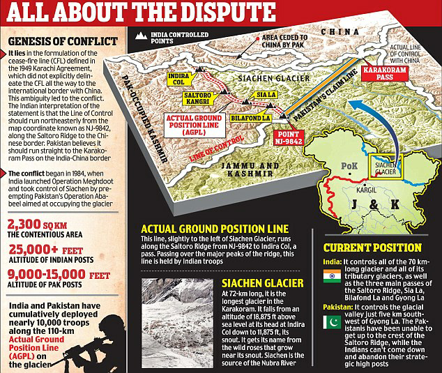
- The Siachen Glacier is a glacier located in the eastern Karakoram range in the Himalayas just northeast of the point NJ9842 where the Line of Control between India and Pakistan ends.
- The Siachen Glacier lies immediately south of the great drainage divide that separates the Eurasian Plate from the Indian subcontinent in the extensively glaciated portion of the Karakoram sometimes called the "Third Pole".
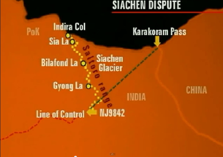
- The glacier lies between the Saltoro Ridge immediately to the west and the main Karakoram range to the east.
- Note: The Saltoro Ridge originates in the north from the Sia Kangri peak on the China border in the Karakoram range.
Length
- At 76 km (47 mi) long, it is the longest glacier in the Karakoram and second-longest in the world's non-polar areas.
Major passes
- The major passes on this ridge are, from north to south, Sia La, Bilafond, and Gyong La.
Drainage
- The glacier's melting waters are the main source of the Nubra River in the Indian region of Ladakh, which drains into the Shyok River.
- The Shyok in turn joins the 3000 kilometre-long Indus River which flows through Pakistan.
- Thus, the glacier is a major source of the Indus and feeds the largest irrigation system in the world.
Administration
- The entire Siachen Glacier, with all major passes, has been under the administration of India (currently as part of the union territory of Ladakh, located in the Kashmir region) since 1984.
- Pakistan maintains a territorial claim over the Siachen Glacier and controls the region west of Saltoro Ridge, lying west of the glacier, with Pakistani posts located 3,000 ft below more than 100 Indian posts on the ridge.
Border Conflict
- Both India and Pakistan claim sovereignty over the entire Siachen region.
- S. and Pakistani maps in the 1970s and 1980s consistently showed a dotted line from NJ9842 (the northernmost demarcated point of the India-Pakistan cease-fire line, also known as the Line of Control) to the Karakoram Pass, which India believed to be a cartographic error and in violation of the Shimla Agreement.
- In 1984, India launched Operation Meghdoot, a military operation that gave India control over all of the Siachen Glacier, including its tributaries.
- Indian troops under Operation Meghdoot pre-empted Pakistan's Operation Ababeel by just one day to occupy most of the dominating heights on Saltoro Ridge to the west of Siachen Glacier.
- The glacier's region is the highest battleground on Earth, where Pakistan and India have fought intermittently since 1984.
- Both countries maintain a permanent military presence in the region at a height of over 6,000 m (20,000 ft).
- India and Pakistan have wished to disengage from the costly military outposts.
- However, after the Pakistani incursions during the Kargil War in 1999, India abandoned plans to withdraw from Siachen without official recognition of the current line of control by Pakistan, wary of further Pakistani incursions if they vacate the Siachen Glacier posts without such recognition.
- Prime Minister Manmohan Singh became the first Indian Prime Minister to visit the arew. After that present Prime Minister Narendra Modi also visited this place.
Actual Ground Position Line (AGPL)
- The Actual Ground Position Line (AGPL) divides current positions of Indian and Pakistani military posts and troops across the entire 110 kilometres long front line in the disputed region of Siachen Glacier.
- AGPL generally runs along the Saltoro Mountains range, beginning from the northernmost point of the (LOC) at Point NJ 9842 and ending in the north on the Indira Ridge at the India-China-Pakistan LAC tri-point near Sia Kangri about 4 km northwest of Indira Col West.
https://epaper.thehindu.com/Home/ShareArticle?OrgId=GCD9D4J7J.1&imageview=0


