Description
Source : Google.com
Disclaimer: Copyright infringement not intended.
Context:
The article examines the gradual sinking of Iraqi land, driven by natural and human-induced factors, and its far-reaching consequences.
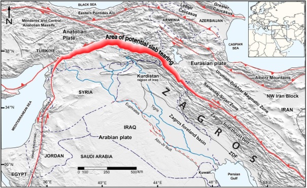
Why is Iraqi territory sinking?
A research team has observed a sinking oceanic slab beneath the Earth’s surface that is responsible for gradually pulling this area downwards. This phenomenon is a result of complex tectonic processes occurring over millions of years.
About Plate tectonics and the Neotethys oceanic slab
- The outer most part of Earth's structure is known as the The lithosphere consists of the crust and a small portion of the upper mantle.
- The lithosphere is divided into a number of tectonic plates. Tectonic plates are gigantic pieces of the Earth's crust and uppermost mantle.
- They are made up of the oceanic crust and continental crust. These plates move and interact with one another, driven by conventional forces within the Earth.
- Plate tectonics is the scientific theory that explains the movement of the Earth’s lithosphere.
- The lithosphere is divided into several plates that float on the semi-fluid asthenosphere
- The interaction of these plates can lead to various geological phenomena, including
- earthquakes,
- volcanic activity,
- mountain formation.
- This phenomenon is happening mainly due to the dynamics between the Arabian and Eurasian continental plates.
- When the Arabian and Eurasian plates collide, a huge crack is formed, called the "Neotethys oceanic slab".
- This slab originated from the bottom of an ancient ocean that existed 66 million years ago.
- Now this slab is slowly sinking into the Earth's mantle (deep layer).
- This process is pulling Iraq's Zagros region down with it, causing this area of Iraq to slowly sink.
Structure and Types of Tectonic Plates
- The Earth has a total of seven major tectonic plates, some of which cover entire continents, while some only cover oceanic areas
|
1. Antarctica and the surrounding oceanic plate.
|
|
2. North American plate.
|
|
3. South American plate.
|
|
4. Pacific plate.
|
|
5. India-Australia-New Zealand plate
|
|
6. Africa with the eastern Atlantic floor plate.
|
|
7. Eurasia and the adjacent oceanic plate
|
Some important minor plates are
(i) Cocos plate: Between Central America and the Pacific plate.
(ii) Nazca plate: Between South America and the Pacific plate.
(iii) Arabian plate: Mostly the Saudi Arabian landmass.
(iv) Philippine plate: Between the Asiatic and Pacific plates.
(v) Caroline plate: Between the Philippine and Indianplate
(North of New Guinea).
(vi) Fuji plate: North-east of Australia
Movement of Tectonic Plates
Convergent boundaries
- In this kind of interaction, two lithospheric plates collide against each other.
- The zone of collision may undergo crumpling and folding, and fold mountains may emerge ( orogenic collision ). Himalayan Boundary Fault is one such example.
- When one of the plates is an oceanic plate, it gets embedded in the softer asthenosphere of the continental plate, and as a result, trenches are formed at the zone of subduction.
- Near the convergent edge a part of the crust is destroyed, hence the name Destructive Edge.
- The subducted material gets heated up and is thrown out, forming volcanic island arc and continental arc systems, and dynamic equilibrium is achieved
Diverging Boundaries
- In this kind of interaction, the plates diverge (move away from each other).
- Mid-ocean ridges are formed due to this kind of interaction. The Mid-Atlantic Ridge is one such example.
- In the continent, the East African Rift Valley is the most important geomorphological feature formed due to the divergence of African and Somali plates.
- Divergent edges are sites of earth crust formation and hence the name constructive edge.
- Earthquakes (shallow focus) are common along divergent edges. Seafloor spreading occurs at divergent plate boundaries
Side-sliding boundaries
- When two plates slide past each other, this process can cause earthquakes.
Example: The San Andreas Fault
Sources:
INDIAN EXPRESS
PRACTICE QUESTION
Q:What is the primary factor contributing to Iraq's sinking land?
A) Increased rainfall
B) Groundwater extraction
C) Volcanic activity
D) Earthquake frequency
Answer b) Groundwater extraction
Explanation: Both natural processes and human activities such as groundwater extraction are key contributors to the land subsidence observed in Iraq, affecting infrastructure and communities.
|


