Disclaimer: Copyright infringement not intended.
Context
Union Home Minister Amit Shah recently held a meeting with the Chief Ministers of Maharashtra and Karnataka on the border dispute between the two States. Both sides agreed that neither State will press their claims further till the judgment of the Supreme Court on this matter and a panel of three ministers each from both states will meet and discuss this issue in detail.
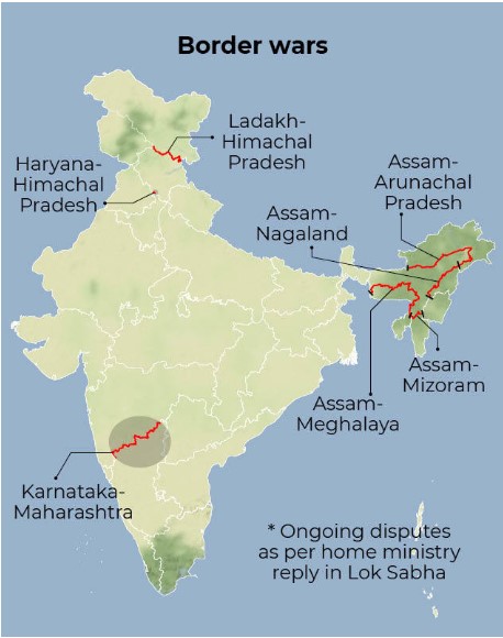
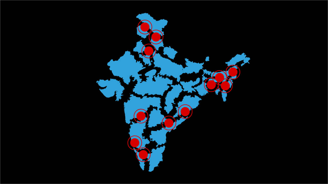
Some Inter-State Border Disputes in India
Assam – Nagaland
These two states share a 434-kilometre boundary, but Nagaland has behaved aggressively towards Assam ever since its inception in 1963 and has in fact encroached on vast tracts of land in upper-Assam districts of Sivasagar, Jorhat and Golaghat.
The first clash between the two states took place at Assam’s Kakodonga Reserve Forest in 1965. Naga militants, allegedly with the support of Nagaland police, killed more than 100 people in the Golaghat district (including Assam Police personnel).
More clashes took place in 1979 and 1985.
The Centre had tried to resolve the turmoil by forming the Sundaram Commission in 1971 and Shastri Commission in 1985, and though both commissions ruled in favour of Assam, no solution was implemented, as Nagaland refused to accept the recommendations. Assam currently has a pending lawsuit with Supreme Court on these border issues: a verdict is still awaited.
Maharashtra-Karnataka
Five decades ago, under the States Reorganisation Act, 1956, some parts of Bombay, Hyderabad, Madras and Coorg were joined with the erstwhile state of Mysore to form Karnataka. In the process, 865 Marathi-speaking villages in Belgaum, Karwar, Gulbarga and Bidar were merged with Karnataka. This is the primary cause of dispute between the two states.
In October 1966, Mehr Chand Mahajan, the third Chief Justice of India was appointed to make recommendations to solve the dispute. This was after a freedom fighter Senapati Bapat and three other leaders went on a fast unto death in Maharashtra, demanding resolution of the dispute.
The Mahajan commission submitted its report in August 1967 and recommended the transfer of 264 villages out of the 865 claimed by Maharashtra (which did not include Belgaum). The commission also recommended the transfer of 247 villages from Maharashtra out of the 516 claimed by Karnataka.
The latest clash between the Marathi people and Karnataka authorities was over the removal of a board saying “Maharashtra Rajya” on July 29, 2014. This clash resulted in the police lathi-charging those involved.
In March 2004, the Congress and NCP-led coalition government of Maharashtra filed a suit in Supreme Court where the matter currently lies. The Shiv Sena has now demanded PM Narendra Modi’s intervention in the matter, though given the BJP’s current relationship with Shiv Sena, they probably shouldn’t be expecting favours from Modi any time soon.
Gujarat – Rajasthan
The dispute between Gujarat and Rajasthan relates to Mangadh Hill, located on the border of the two states. Gujarat claims half of the hill, while Rajasthan claims the entire hill is theirs. The dispute is 40 years old, though the Rajasthan Government presently has control over the hill.
According to folklore, hundreds of tribals were killed in the hills while protesting against British rule in 1911. Their relatives gather there every year in the month of January to pay their respects to the dead. The Panchmahal district administration of Gujarat recently started constructing a road to reach hill, along with forest huts and hand pumps for the pilgrims. The Rajasthan government raised strong objections to this.
Many land owners have filed complaints for illegal encroachment on their land, alleging that Rajasthanis owning the adjacent pieces of land indulge in illegal activities on their lands. So far, no development from both sides has taken place to resolve the issue.
.jpg)
Karnataka- Kerala
In 1956, the Reorganisation Committee decreed that the district of Kasaragod, comprising mainly of Kannada- speaking people, be made part of Kerala. Since then, people in the district have complained of “step-motherly” treatment from Kerala Government.
In 1967, a committee headed by a retired judge of the Supreme Court, Justice M. Mahajan, was constituted to look into the matter. The committee recommended that Kasargod Taluk, north of Chandragiri and Payaswini rivers should be given to erstwhile Mysore – which later became Karnataka.
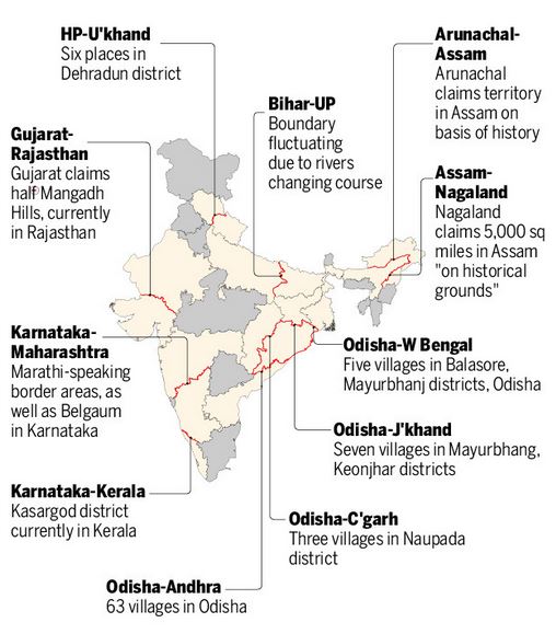
Odisha – West Bengal
The dispute between these states has been going on for more than 30 years. This is a fierce territorial dispute between the states at all levels – points of skirmish are farmers disputing land at the border, land grabbing by both states to build government institutions and people living at the border holding dual voter ID cards to achieve political motives.
More recently, the government of Odisha and the government of West Bengal were at loggerheads over an island called Kanika Sands in the Bay of Bengal, with both governments laying claim to the island.
In 2010, the Kolkata Port Trust (KoPT) published a tender notice in several newspapers that said KoPT had extended the port limits to include Kanika Sands. The Odisha government opposed the notification saying that the island was located off the Odisha coast and they should be allowed to exclusively grant tenders for work on Kanika Sands.
The Shipping Ministry eventually intervened in 2013, ruling in favour of Odisha – they extended the port limit of Paradip Port Trust (PPT) to cover Kanika Sands.
Assam-Mizoram
This is the conflict that has led to renewed discussions on state borders. Mizoram used to be a district of Assam before being carved out as a separate union territory and later, becoming another state. Because of the history, the district's borders did not really matter for locals for a long time. Mizoram shares a border with the districts Cachar, Hailakandi and Karimganj of Assam.
Over time, the two states started having different perceptions about where the demarcation should be. While Mizoram wants it to be along an inner line notified in 1875 to protect tribals from outside influence, which Mizos feel is part of their historical homeland, Assam wants it to be demarcated according to district boundaries drawn up much later.
Haryana-Himachal Pradesh
The two northern states have a border dispute over the Parwanoo region, which lies next to the Panchkula district of Haryana. Haryana has laid a claim to a large part of the land in the area and has accused the hill state of encroaching some of its area.
Ladakh-Himachal Pradesh
The union territory of Ladakh and Himachal both claim Sarchu, a major halt point for those travelling through Leh-Manali highway. The region is located between Himachal Pradesh's Lahaul and Spiti district and Ladakh's Leh district.
Maharashtra-Karnataka
Perhaps the biggest border dispute in the country is between Maharashtra and Karnataka over the Belgaum district. Belgaum has a sizable population of both Marathi and Kannada speaking people and the two states have wrestled over the region in the past. The area used to be part of the Bombay presidency from the time of the Britishers but was included in Karnataka after the states reorganisation exercise in 1956.
Assam-Arunachal Pradesh
Assam shares a 804.10 km inter-state boundary with Arunachal Pradesh. The state of Arunachal Pradesh, created in 1987, claims some land that traditionally belonged to its residents has been given to Assam. A tripartite committee had recommended that certain territories be transferred from Assam to Arunachal. The two states have since been battling it out in the Supreme court over the issue. Some incidents of local violence have been reported from the borders.
Assam-Nagaland
The border dispute between the two states has been going on since the formation of Nagaland in 1963. The two states lay claim to Merapani, a small village next to the plains of Assam's Golaghat district. There have been reports of violent clashes in the region since the 1960s.
Assam-Meghalaya
Meghalaya has identified close to a dozen areas on which it has a dispute with Assam about the state’s borders. The chief ministers of the two states, Himanta Biswa Sarma and Megahalya’s Conrad K Sangma, recently held the first-ever meeting on inter-state border dispute. Both the states have agreed to individually assess the claims for all 12 areas flagged by Meghalaya in the past. A second round of discussion between the two state CMs will be held next month.
Causes of Inter State Disputes in India
British Policies
Shifting of responsibility
No Constitutional Mechanism
Conflict over land resources
Non-Compliance and non-implementation with Committee Recommendations
Vote Bank Politics
Regionalism
Geography
Colonial maps and failure of post-independence demarcation

Resolving Conflicts
Way Ahead
https://sansadtv.nic.in/episode/perspective-inter-state-border-dispute-15-december-2022
© 2025 iasgyan. All right reserved