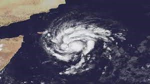
CYCLONE HAMOON
Disclaimer: Copyright infringement not intended.
Context
- Cyclones Tej and Hamoon are considered to be twin cyclones developed over the north Indian Ocean.
- The last such twin cyclones 'Luban' and 'Titli' were recorded in 2018, according to the IMD.
Details
- After 5 years, the Indian Ocean's margin seas are witnessing cyclones simultaneously.
- The last time this occurred was in 2018, when Cyclones Luban and Titli formed over the Arabian Sea and the Bay of Bengal, respectively.
What reasons are causing Cyclone Hamoon to strengthen?
- Tej's shift in the Arabian Sea: In a twin cyclonic system — Tej and Hamoon — one is generally stronger than the other. Since Tej has already made landfall and is gradually diminishing, Hamoon appears to be strengthening.
- Surface temperature: The sea surface temperature in the location where it is now located is higher than in the previous place, adding to the intensification.
Seasonal Patterns in the North Indian Ocean, a Cyclone Breeding Ground
- The North Indian Ocean, which includes the Bay of Bengal and the Arabian Sea, has a history of cyclonic activity.
- The post-monsoon months, particularly from October to December, are marked by an increased risk of cyclonic storm development. November, in particular, is the most auspicious month for the emergence of these strong natural occurrences.

Types of Cyclones
- Cyclones in the North Indian Ocean are typically categorized into various types based on their characteristics.
- Understanding these distinctions is crucial for preparedness and mitigation efforts.
Tropical Cyclones
- Tropical cyclones, often referred to as hurricanes or typhoons in other parts of the world, are one of the most destructive types of cyclones.
- They are characterized by strong winds exceeding 74 miles per hour (119 kilometers per hour) and heavy rainfall.
- The North Indian Ocean witnesses its share of tropical cyclones, which could result in widespread devastation.
Severe Cyclonic Storms
- Severe cyclonic storms are at the next level of intensity.
- These storms have even stronger winds and more significant potential for destruction.
- They often lead to storm surges, which can inundate coastal areas, causing severe flooding.
Very Severe Cyclonic Storms
- As the name suggests, very severe cyclonic storms are even more powerful and can result in extreme wind speeds and torrential rainfall.
- The impact of these storms is often catastrophic, affecting not only coastal regions but also areas further inland.
Super Cyclones
- Supercyclones are the most intense and destructive cyclones in the North Indian Ocean.
- They are characterized by wind speeds exceeding 131 miles per hour (211 kilometers per hour) and are capable of causing widespread devastation, including damage to infrastructure and loss of life.
Tropical Cyclone
- The tropical cyclone, also called a typhoon or hurricane, is an intense circular storm that originates over warm tropical oceans and is characterized by low atmospheric pressure, high winds, and heavy rain.
- In the North Atlantic Ocean and the eastern North Pacific, they are called hurricanes, and in the western North Pacific around the Philippines, Japan, and China the storms are referred to as
- In the western South Pacific and Indian Ocean, they are variously referred to as severe tropical cyclones, tropical cyclones, or simply cyclones.
- Tropical cyclones rotate in a counterclockwise (or cyclonic) direction in the Northern Hemisphere and in a clockwise (or anticyclonic) direction in the Southern Hemisphere.
How do cyclones form?
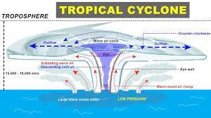
- Tropical cyclones form only over warm ocean waters near the equator.
- To form a cyclone, warm, moist air over the ocean rises upward from near the surface.
- As this air moves up and away from the ocean surface, it leaves less air near the surface. So basically, as the warm air rises, it causes an area of lower air pressure below.
- Air from surrounding areas with higher air pressure pushes into the low-pressure area. Then this new “cool” air becomes warm and moist and rises, too. And the cycle continues.
- As the warmed, moist air rises and cools the water in the air forms clouds.
- The whole system of clouds and wind spins and grows, fed by the ocean’s heat and water evaporating from the ocean surface.
- As the storm system rotates faster and faster, an eye forms in the center.
- It is very calm and clear in the eye, with very low air pressure. Higher-pressure air from above flows down into the eye.
- When the winds in the rotating storm reach 39 mph (63 kph), the storm is called a “tropical storm”.
- And when the wind speeds reach 74 mph (119 kph), the storm is officially a “tropical cyclone” or
- Tropical cyclones usually weaken when they hit land because they are no longer being “fed” by the energy from the warm ocean waters.
- However, they often move far inland, dumping many centimeters of rain and causing lots of wind damage before they die out completely.
|
PRACTICE QUESTION Discuss the key meteorological factors contributing to the formation and intensification of tropical cyclones.(150 words) |
1.png)