Increasing trend of cyclones in Arabian Sea
Context
- An analysis of past data of cyclones by IMD over the North Indian Ocean (Bay of Bengal and Arabian Sea) during the period 1891–2020 indicates that the frequency of extremely severe cyclonic storms has increased in recent few years over the Arabian Sea since 1990, and remained the same over the Bay of Bengal.
- The highest loss of lives occurred during Cyclones Tautkae, 2021, (118 deaths).
The usual trend: India’s east coast is a magnet for cyclones
- Though both are located in the same latitude band and receive the same amount of solar radiation from the Sun, the Bay of Bengal is much warmer than the Arabian Sea and many more storms brew over the bay. Reasons:
- Oceanic circulation and heat removal: The winds over the Arabian Sea are stronger because of the presence of the mountains of East Africa. These strong winds force a much more vigorous oceanic circulation and the heat received at the surface is transported into the deeper ocean.
The winds over the Bay of Bengal, in contrast, are more sluggish and the bay is unable to remove the heat received at the surface. Hot water temperature is the basic criteria for the development and intensification of cyclones. The average temperature in the Bay of Bengal around the year is high - about 28 degrees.
- Sea surface temperature: The bay receives more rainfall; it also receives more freshwater from the large rivers, especially the Ganga and the Brahmaputra, that empty into it.
This freshens the surface of the BOB and stabilizes the water column, making it more difficult for the winds to mix the warm, stable surface layer with the cooler waters below.
In the Arabian Sea, there is no such stabilizing effect. As a consequence, the mixing with the cooler waters below is more vigorous. Since a sea surface temperature of about 28ºC is necessary for convection to take place in the atmosphere, this condition is satisfied in the Bay of Bengal but not in much of the Arabian Sea.
- Pacific Ocean: Pacific Ocean is a hot bed for cyclonic activities and hence typhoons originating in the Pacific ocean influences the cyclones in Bay of Bengal. This is not the case in Arabian Sea.
- Salinity: The Arabian Sea is saltier than the Bay of Bengal. As a result, it easily gets heated up and evaporates faster. And the rate of evaporation is way higher than the rate of precipitation due to lack of supply of fresh water in Arabian Sea.
- Movement: According to IMD cyclones originating in Arabian Sea move northwest. So they actually move away from Indian mainland.
Why has Arabian Sea turned into a cyclone hotspot in the recent past?
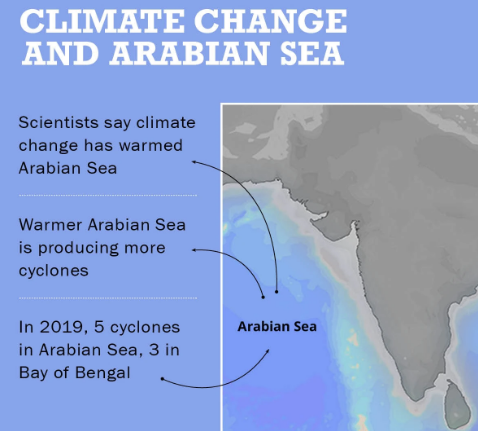
- According to the India Meteorological Department, the frequency and intensity of cyclonic activity in the Arabian Sea was the highest it had been in over a century, in 2019.
- According to the Intergovernmental Panel on Climate Change (IPCC), a United Nations body, the sea surface temperature of the Arabian Sea is rising.
- Rising sea surface temperatures (SST) in the Arabian Sea are contributing to the formation of an increased number of cyclones.
- Scientists attribute the increased frequency of cyclones in the Arabian Sea to climate change.
- Climate scientist Hiroyuki Murakami in his study found that 64 per cent of cyclones in the Arabian Sea in recent years were caused by climate change.
- SST in the Arabian Sea rose by a staggering 0.36 degrees Celsius, compared with the baselines temperatures between 1981 and 2010.
- The increase in temperature is in the zone of 1.2-1.4 degree Celsius.
- Heat works as food for cyclones. The temperature in the Bay of Bengal usually remains above 28 degrees Celsius.
- The Arabian Sea, in contrast, used to have a temperature 1-2 degree Celsius lower than that in the Bay of Bengal.
- Now, the rise in temperature in the Arabian Sea has pushed it in the 30 to 31-degree Celsius zone off the India’s west coast.
What are Tropical Cyclones?
- Cyclones that develop in the regions between the Tropic of Capricorn and Tropic of Cancer are called tropical cyclones.
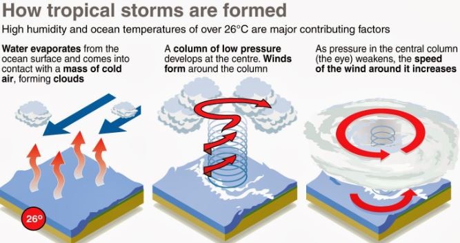
- Tropical cyclones are intense circular storms that originate over warm tropical oceans.
- They rotate in anti-clockwise direction in the Northern Hemisphere and in a clockwise direction in the Southern Hemisphere.
- They are characterized by low atmospheric pressure, high winds, and heavy rain.
- Drawing energy from the sea surface a tropical cyclones maintains its strength as long as it remains over warm water.
Note: Extra tropical cyclones occur in temperate zones and high latitude regions, though they are known to originate in the Polar Regions.
Tropical Storms
- Hurricanes, cyclones and typhoons are all types of tropical storms. But are given different names depending on where they appear.
- Hurricanes are tropical storms that form over the North Atlantic Ocean and Northeast Pacific.
- Cyclones are formed over the South Pacific and Indian Ocean.
- Typhoons are formed over the Northwest Pacific Ocean.
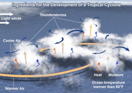
Favorable Conditions for Tropical Cyclone Formation
- Large sea surface with temperature higher than 27° C,
- Presence of the Coriolis force enough to create a cyclonic vortex,
- Small variations in the vertical wind speed,
- A pre-existing weak low-pressure area or low-level-cyclonic circulation,
- Upper divergence above the sea level system,
KEY CONCEPTS
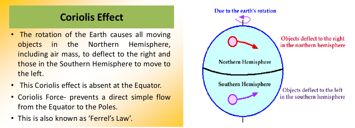
Coriolis effect
The Coriolis effect is the apparent acceleration of a moving body as a result of the Earth's rotation. It makes things (like planes or currents of air) traveling long distances around the Earth appear to move at a curve as opposed to a straight line. The Coriolis effect is an important determinant of wind direction on a global scale.
Wind shear
Wind shear sometimes referred to as wind gradient, occurs when there is a change in the direction or speed of wind usually at short distances. Atmospheric wind shear is normally described as either vertical or horizontal wind shear.
Vertical wind shear is a change in wind speed or direction of winds at increasing heights in the atmosphere. Horizontal wind shear is a change in wind speed with change in lateral position for a given altitude. For cyclones to develop, low vertical wind shear is a must.
Tropical Cyclone Vs Extra-tropical Cyclone
|
Basis |
Tropical Cyclone |
Extra-tropical Cyclone |
|
Characteristics |
A low-pressure centre, a closed low-level atmospheric circulation, strong winds, and a spiral arrangement of thunderstorms that produce heavy rain. |
A large scale low-pressure weather systems that occur in the middle latitudes of the Earth. |
|
Formation |
It gets intensified over warm tropical oceans and required temperature higher than 27° C, presence of the Coriolis force, small variations in the vertical wind speed, a pre-existing weak low- pressure area or low-level-cyclonic circulation and upper divergent above the sea level system. |
It gets intensified any part of extratropical regions of the Earth (usually between 30° and 60° latitude from the equator), either through cyclogenesis or extratropical transition. |
|
Movement |
It moves from east to west. |
It moves from west to east. |
|
Nature of Cyclone |
Violent storms |
Static, not violent |
|
Type |
Warm Core |
Cold Core |
1.png)