LIDAR survey of forest areas
GS PAPER III: Science and Technology- developments and their applications and effects in everyday life.
Context: Detailed Project reports of LIDAR survey of forest areas in 10 states for water and fodder augmentation released.
- The ten states includes Assam, Bihar, Chhatisgarh, Goa, Jharkhand, Madhya Pradesh, Maharashtra, Manipur, Nagaland, and Tripura.
- Projects will help augment water and fodder in forest areas and enrich efficiency of regeneration of forests
- The project was awarded to WAPCOS, a PSU under the aegis of Ministry of Jal Shakti, Government of India.
- It is a first of its kind and a unique experiment using LiDAR technology.
- It will help augment water and fodder in jungles areas thereby reducing human-animal conflict, help in groundwater recharge, help local communities and also asked state forest departments to use CAMPA funds towards implementation of these projects in right earnest and in accordance with the ‘Ridge to Valley’ approach of watershed management.
- WAPCOS has prepared these DPR’s using LiDAR technology in which the 3-D(three dimensional) DEM (Digital Elevation Model), imagery and layers of the project areas are used for recommending different types of Soil & Water conservation structures such as Anicut, Gabion, Gully Plug, Mini percolation tank, Percolation Tank, Field bund, Sunken pond, Farm pond etc.
- These structures will help in catching the rain water and prevent stream run off, which will help in recharging of Ground water.
- States/UTs identified one major ridge inside a forest block with the criteria that area selected should have average rainfall of the state, and the area requires assisted natural generation which means the density of forests should be less than 0.4 or below, but should have reasonable potential to regenerate with the ANR interventions.
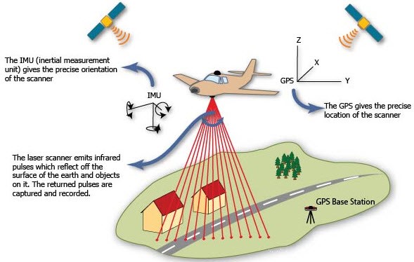
LiDAR technology:
- Lidar — Light Detection and Ranging — is a remote sensing method used to examine the surface of the Earth.
- A lidar instrument principally consists of a laser, a scanner, and a specialized GPS receiver.
- Airplanes and helicopters are the most commonly used platforms for acquiring lidar data over broad areas.
- Two types of lidar are topographic and bathymetric. Topographic lidar typically uses a near-infrared laser to map the land, while bathymetric lidar uses water-penetrating green light to also measure seafloor and riverbed elevations.
- Lidar systems allow scientists and mapping professionals to examine both natural and manmade environments with accuracy, precision, and flexibility.
1.png)