New trend of developing strong cyclones in the Arabian Sea
GS PAPER I: Important Geophysical Phenomena such as earthquakes, Tsunami, Volcanic activity, cyclone etc.
Context: Cyclone Tauktae (pronounced Tau-Te), classified as a very severe cyclonic storm (VSCS) and developed in the Arabian Sea, is expected to hit southern Gujarat.
- In recent years, strong cyclones have been developing in the Arabian Sea more frequently than earlier.
Why is Cyclone Tauktae unique?
- Tauktae is the fourth cyclone in consecutive years to have developed in the Arabian Sea, that too in the pre-monsoon period (April to June).
- All these cyclones since 2018 have been categorised either ‘Severe Cyclone’ or above.
What is aiding such rapid intensification?
- Any tropical cyclone requires energy to stay alive. This energy is typically obtained from warm water and humid air over the tropical ocean.
- Currently, sea water up to depths of 50 metres has been very warm, supplying ample energy to enable the intensification of Cyclone Tauktae.
- The more the heat released through condensation of water vapour, the steeper the drop in pressure. A low-pressure system undergoes multiple stages of intensification to form cyclones.
- Typically, tropical cyclones in the North Indian Ocean region (Bay of Bengal and Arabian Sea) develop during the pre-monsoon and post-monsoon (October to December) periods.
- May-June and October-November are known to produce cyclones of severe intensity that affect the Indian coasts.
Is the Arabian Sea becoming cyclone-friendly ?
- Annually, five cyclones on average form in the Bay of Bengal and the Arabian Sea combined.
- Of these, four develop in the Bay of Bengal, which is warmer than the Arabian Sea.
- In the Arabian Sea, cyclones typically develop over Lakshadweep area and largely traverse westwards, or away from India’s west coast.
- The frequency and intensity of cyclones in the Arabian Sea have increased in recent years.
- This is because of the rapid warming that has made the relatively cooler Arabian Sea (compared to the Bay of Bengal) a warm pool region that can actively support cyclone formation.
- However, in recent years, meteorologists have observed that the Arabian Sea, too, has been warming. This is a phenomenon associated with global warming.
Tropical cyclone
- Tropical cyclone, also called typhoon or hurricane, an intense circular storm that originates over warm tropical oceans and is characterized by low atmospheric pressure, high winds, and heavy rain.
- In the North Atlantic Ocean and the eastern North Pacific they are called hurricanes, and in the western North Pacific around the Philippines, Japan, and China the storms are referred to as typhoon
- In the western South Pacific and Indian Ocean they are variously referred to as severe tropical cyclones, tropical cyclones, or simply cyclones.
- Tropical cyclones rotate in a counterclockwise (or cyclonic) direction in the Northern Hemisphere and in a clockwise (or anticyclonic) direction in the Southern Hemisphere.
How do cyclones form?
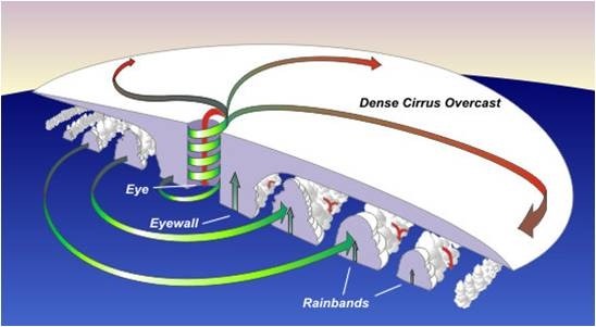
The above figure shows how cyclones form. The green arrows show where warm air is rising. The red arrows indicate where cool air is sinking.
- Tropical cyclones form only over warm ocean waters near the equator.
- To form a cyclone, warm, moist air over the ocean rises upward from near the surface.
- As this air moves up and away from the ocean surface, it leaves is less air near the surface. So basically as the warm air rises, it causes an area of lower air pressure below.
- Air from surrounding areas with higher air pressure pushes in to the low pressure area. Then this new “cool” air becomes warm and moist and rises, too. And the cycle continues.
- As the warmed, moist air rises and cools the water in the air forms clouds.
- The whole system of clouds and wind spins and grows, fed by the ocean’s heat and water evaporating from the ocean surface.
- As the storm system rotates faster and faster, an eye forms in the centre.
- It is very calm and clear in the eye, with very low air pressure. Higher pressure air from above flows down into the eye.
- When the winds in the rotating storm reach 39 mph (63 kmph), the storm is called a “tropical storm”.
- And when the wind speeds reach 74 mph (119 kmph), the storm is officially a “tropical cyclone” or
- Tropical cyclones usually weaken when they hit land, because they are no longer being “fed” by the energy from the warm ocean waters.
- However, they often move far inland, dumping many centimeters of rain and causing lots of wind damage before they die out completely.
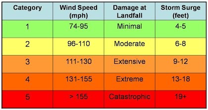
Cyclone Categories
1.png)