TYPHOON IN-FA
Context
- Typhoon In-fa has moved to Shanghai and continued to lash the city after making landfall at the nearby island-city of Zhoushan.
Details
- A severe Tropical Storm In-fa is known as a Tropical Storm Fabian in the Philippines.
- Storm In-Fa is officially the 7th tropical storm of the 2021 Pacific typhoon season.
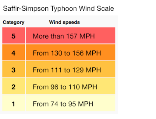
- It will be the third typhoon after Category 5 Surigae (mid-April) and Category 1 typhoon Champi (late June).
Tropical Storms
- Hurricanes, cyclones and typhoons are all types of tropical storms. But are given different names depending on where they appear.
- Hurricanes are tropical storms that form over the North Atlantic Ocean and Northeast Pacific.
- Cyclones are formed over the South Pacific and Indian Ocean.
- Typhoons are formed over the Northwest Pacific Ocean.
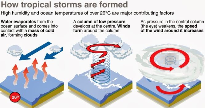
Favorable Conditions for Tropical Cyclone Formation
- Large sea surface with temperature higher than 27° C,
- Presence of the Coriolis force enough to create a cyclonic vortex,
- Small variations in the vertical wind speed,
- A pre-existing weak low-pressure area or low-level-cyclonic circulation,
- Upper divergence above the sea level system,
What has fueled the In-fa storm?
- Favorable conditions under the MJO over the Pacific Basin have helped the storm to intensify since its birth in the Philippine Sea.
- The sea surface temperatures across the western Pacific Ocean are extremely warm, even hot in places this summer.
- A large portion of the Philippine Sea and the South China Sea is very hot with sea surface water temperatures 30 to nearly 32 °C (86-88 °F) in some spots.
- This is *extremely* supportive of healthy fuel for the deep convective storms.
- Strongly anomalous sea temperature often leads to the explosive development of deep storms that develop well-organized tropical cyclones.
Sea Temperature Anomaly
- Most of the western Pacific remains with well above-average sea waters.
- Sea waters are also warm further west across the South China Sea and towards the Indian Sea.
- But the highest sea surface temperature anomalies are observed around Japan and across the Northwest Pacific.
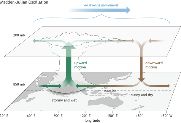
- These very warm seas again coincide with another tropical factor that has a huge effect on tropical cyclone activity worldwide. It is known as the MJO – The Madden-Julian Oscillation.
What is the MJO wave?
- The Madden-Julian Oscillation (MJO) is the major fluctuation in tropical weather on weekly to monthly timescales.
- The MJO can be characterized as an eastward moving 'pulse' of cloud and rainfall near the equator that typically recurs every 30 to 60 days.
- It’s a traversing phenomenon and is most prominent over the Indian and Pacific Oceans.
- And the intensity of the MJO wave has recently significantly increased over the Western Pacific and lead to the formation of Typhoon In-Fa.
- The MJO has two parts, one side is the enhanced rainfall (we call it the wet phase) and the other side is the suppressed rainfall (we call it a dry phase).
- This means that there are increased storms with a lot of rainfall on one side and reduced storm potential and drier weather on the other side.
- The wet phase leads to diverging (ascending) air parcels while the dry phase brings converging (descending) air parcels.
- This horizontal movement of the air is referred to as the Velocity Potential (VP) in the tropics.
How does MJO affect Indian Monsoon?
- The journey of MJO goes through eight phases.
- When it is over the Indian Ocean during the Monsoon season, it brings good rainfall over the Indian subcontinent.
- On the other hand, when it witnesses a longer cycle and stays over the Pacific Ocean, MJO brings bad news for the Indian Monsoon.
- Basically, it is linked with enhanced and suppressed rainfall activity in the tropics and is very important for the Indian monsoonal rainfall.
- It has also been established that if the periodicity of MJO is nearly 30 days then it brings good rainfall during the Monsoon season.
- If it is above 40 days then MJO doesn't give good showers and could even lead to a dry Monsoon.
- Shorter the cycle of MJO, better the Indian Monsoon. Simply because, it then visits the Indian Ocean more often during the four month-long period.
- Presence of MJO over the Pacific Ocean along with an El Nino is detrimental for Monsoon rains.
https://newsonair.com/2021/07/26/typhoon-in-fa-disrupts-life-in-eastern-china/
1.png)