Urban Flooding
Disclaimer: Copyright infringement not intended.
Context
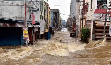
- The overflowing of Bellandur, Varthur, Saul Kere and Kaikondrahalli lakes in Bengaluru has put the spotlight back on the loss of interconnectivity of water bodies, which is being blamed for the recent urban flooding.
- While the government took up the desilting work of Bellandur and Varthur lakes in June 2020, that work is yet to be completed.
Background:
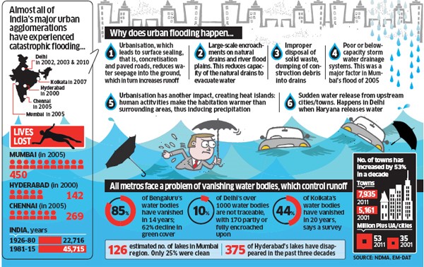
- There has been an increasing trend of urban flood disasters in Indiaover the past several years whereby major cities in India have been severely affected.
- Some of the most notable amongst them are Hyderabad in 2000 & 2020, Ahmedabad in 2001 & 2020, Delhi in 2002, 2003, 2009 & 2010, Chennai in 2004 & 2015, Mumbai in 2005, Surat in 2006, Kolkata in 2007 and Srinagar in 2014.
- According to a recent report on Urban planning capacity in India by NITI Aayog Urban planning has not received adequate attention and 65% of the 7933 urban settlements do not have any master plan.
- Waterlogging — a prelude to urban flooding — is a common sight in urban Indiaduring the monsoon.
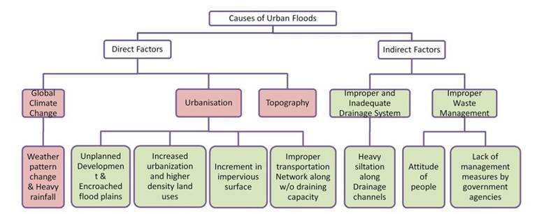
- Urban flooding has also become increasingly common, as the changing weather pattern resulted in more high intensity rain in fewer rain days.
- COVID-19 has increased the problem of waterlogging this yearas pre-monsoon desilting of drains was not carried out in full capacity.
About Urban Flooding:
- Urban flooding is the inundation of property in a built environment, particularly in densely populated urban areas, caused by intense rainfall (on impermeable surfaces) which overwhelms the capacity of drainage systems.
- Urban flooding is significantly different from rural flooding as urbanization leads to developed catchments, which increases the flood peaks from 1.8 to 8 times and flood volumes by up to 6 times.
- Consequently, flooding occurs very quickly due to faster flow times.
- Urban areas are densely populated and people living in vulnerable areas suffer due to flooding and the secondary effect of exposure to infection also has its toll in terms of human suffering, loss of livelihood and in extreme cases, loss of life.
- Increasing trend of urban flooding is a universal phenomenon and poses a great challenge to urban planners the world over.
- Urban areas are also centres of economic activities with vital infrastructure which needs to be protected 24x7.
Urban Flood Risk in India:
- A special feature in India is that we have heavy rainfall during monsoons.
- Storm surges can also affect coastal cities/ towns.
- Sudden release or failure to release water from damscan also have severe impact.
- In addition, the urban heat island effect has resulted in an increase in rainfall over urban areas.
- Global climate changeis resulting in changed weather patterns and increased episodes of high intensity rainfall events occurring in shorter periods of time.
- Then the threat of sea-level riseis also looming large, threatening all the coastal cities.
- Cities/towns located on the coast, on river banks, upstream/ downstream of dams, inland cities and in hilly areascan all be affected.
- Further, the systems very often do not work to the designed capacities because of very poor maintenance.
- Encroachmentsare also a major problem in many cities and towns.

Impacts:
Urban flooding has wide ranging impacts:
- Damage to vital urban infrastructurecausing disruptions in transport and power
- Loss of life and damage to property
- Risk of epidemicsdue to exposure to waterborne and vector borne infections
- Deterioration of water quality
- Economic lossesdue to disruption in industrial activity, supply chains etc
- Displacement of populationin low lying areas
- Accidents and firesdue to short circuit
NDMA guidelines on urban flooding:
- It designates Ministry of Urban Development as the Nodal Ministry for Urban Flooding.
- Among key provisions of the Guideline are Early Warning System and Communication
- Create a National Hydro-meteorological Network- for providing early warning in all urban centres.
- Developing local networks for real-time rainfall data collection with a ‘Local Network Cell’ in the IMD headquarters.
- Sub divide Cities/ towns on the basis of watersheds and develop a protocolfor forecasting rainfall for urban areas on the basis of watershed.
- Design and Management of Urban Drainage System
- A watershed based and ward-based inventory of the existing storm water drainage systemto be prepared.
- Pre-monsoon desiltingof all major drains to be completed by March 31 each year.
- Every building in an urban area must have rainwater harvestingas an integral component.
- Concept of Rain Gardensto be incorporated in planning for public parks.
- Integrated Planning and interactionsbetween Water and Solid Waste Management.
Case studies:
Mumbai:
- Mumbai is often referred as a prime example when it comes to discussing urban floods in India.
- A United Nations Habitat paper on monsoon floods in Mumbai mentions that even after 10 days of intense rainfall, the suburban and low-lying areas near the Mithi river remain waterlogged without services, appropriate shelter, potable water or food.
- This area is estimated to have 70 per cent occupancy by slums and pavement dwellers, including one of the largest slums in the world — Dharavi.
- The recurrent urban flooding in Mumbai is a prime example of lagged response by the government.
- The major factor is the city's old drainage system, which is heavily silted and damaged.
- While there have been multiple plans and proposals to update Mumbai's storm water disposal system, no conclusion has been arrived at it yet.
- The BRIMSTOWAD (Brihanmumbai Storm Water Disposal System) project, proposed in 1993, was intended to be a long-term roadmap for the city's vulnerability to flooding; but no action was taken on it till the major flooding of 2005.The system has not been fully updated yet.
- Recently, Ministry of Earth Sciences (MoES) in coordination with Municipal Corporation of Greater Mumbai developed an Integrated Flood Warning System for Mumbai called ‘IFLOWS-Mumbai’.
Gurugram:
- It takes only one seasonal downpour to bring the city to a standstill.
- Gurugram has seen an explosive growth in the urban population as well as infrastructure in the recent years.
- As a result of poor planning, unregulated construction and mismanagement of environmental resources, water reservoirs and wetlands have vanished over the years.
- The number of water bodies has reduced to 123 in 2018 from 644 in 1956.
- Green cover is only 9 per cent, which ideally should have been at least 33 per cent.
- Better late than never, the city has fortunately identified areas of intervention and is drafting a district action plan as part of ‘Gurujal’ project.
- The Municipal Corporation of Gurugram (MCG) has identified 38 sensitive areas that are most prone to urban flooding.
- The district administration is pushing for several measures to improve water management including stringent building bylaws, enforcement and campaigning.
Way forward:
- Integrated approach should be adoptedfor sustainable urban planning by empowering and educating Urban Local Bodies in decision making and planning of flood mitigation infrastructure.
- Focus on increasing the resilience of communities and adaptive capacity of our infrastructure is needed.
- Water sensitive urban design and planning techniques— especially in the context of implementation — are of utmost importance. These methods take into consideration the topography, types of surfaces (pervious or impervious), natural drainage and leave very less impact on the environment.
- Vulnerability analyses and risk assessments should form part and parcel of city master plans.
- Disabling encroachment in sensitive zonesthrough robust anti-encroachment laws and by providing adequate affordable housing can help reduce number of persons vulnerable to changing climate.
1.png)